Surely you’ve seen those whimsical national maps that portray cartoonish graphics to represent each of the 50 states. You know – the ones that feature a lassoing cowboy in Wyoming and a stand of cornstalks in Nebraska. When characterizing Arizona, they invariably plant a large saguaro cactus in the middle of the state and call it good. It is no wonder that, to the uninitiated, the Grand Canyon State is viewed only as a place of shifting sand, monolithic rock formations, and cacti. If you fit in that category of the innocently misinformed, it’s time for an Arizona motorcycle ride to the expansive Mogollon Rim and the White Mountain regions.

In anticipation of 50-degree temperature swings, I pack the saddlebags on the BMW R 1200 GS. In a move that runs counter to the Arizona stereotype, I carefully roll my rain gear and place it in a quickly accessible corner of my hard luggage. August is the heart of the monsoon season in the Southwest, and Arizona’s high country is subject to quickly developing afternoon thundershowers. With the final click of the luggage latch, I am ready for a three-day, late-summer ride along the Mogollon Rim and the Coronado Trail.
Riding the Rim | Arizona Motorcycle Ride
The starting point of my high-country ride is the tiny mountain town of Strawberry, Arizona. Alpine-styled chalets and A-framed cabins dominate the architectural styling of the tiny hamlet that was established in the 1800s. The town rests just beneath the Mogollon Rim, the 200-mile escarpment that forms the southwestern edge of the Colorado Plateau.
Following the rim, I roll out of town on Arizona State Route 260. The two-lane highway carves through ponderosa pines, junipers, and oaks – not a saguaro in sight. After a few miles of sweeping turns, I enter another beautiful mountain village. The town of Pine is larger than Strawberry but not by much. Like its neighboring town, Pine rests at more than a mile in elevation. Diners, knick-knack shops, and even a microbrewery line the road.

After Pine, the great riding continues as State Route 260 winds on with the massive rim to my clutch side and a dense conifer forest to the other until I enter the town of Payson. This is the largest town in the area and boasts many hotels, restaurants, and stores. In the heart of Payson, SR-260 takes a sharp left to shift my direction from southeast to due east. The rim is still to my left, and I am going to follow its rocky lip toward the White Mountains.

Along the way, the trees that line the road shrink from tall pines to junipers for about a 10-mile stretch. The rim is even more visible over the lower foliage. This high chaparral environment again morphs into an alpine region as SR-260 climbs into the Tonto National Forest. The road is seldom straight and is defined by smooth pavement and great sweeping turns.
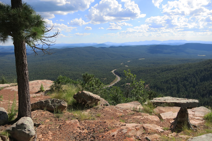
After the small developments of Kohl’s Ranch and Christopher Creek, the road begins a steep, diagonal ascent up the face of the rim. The views become enormous. I have planned a side jaunt to Woods Canyon Lake, which is the first of a series of high mountain rim lakes. I am now on top of the rim, and the road that leads to and from the lake offers a spectacular view of the rugged and expansive Tonto National Forest and its huge ponderosa pine forest.

After taking in the panoramic view, I make my way to the lake. Woods Canyon is a picturesque little alpine lake that is famous for its deep, cold water and abundant wildlife, and I spot both deer and elk while taking in the cool air at the 7,500-foot elevation. After a little time enjoying the mountain ambience, I make my way back to SR-260 and continue my eastern trek.
See all of Rider’s U.S. West motorcycle rides here.
I ride through the mountain towns of Heber-Overgaard and Show Low as I climb deeper into the White Mountains. The increase in altitude has added aspen to the palate of trees that line the road. This is prime motorcycling country with cool air, well-maintained tarmac, and beautiful scenery. The occasional roadside deer carcass serves to remind me that vigilance and reasonable speeds are warranted as I navigate the mountain curves.

I decide on the fly that I will find lodging in the largest town in the White Mountains, Pinetop-Lakeside. After securing a room in a small, log-sided motel, I pull off my riding gear, don some civilian duds, and walk the town. The mid-afternoon thunderheads are building, and I am glad to be planted for the night. I have some good old American comfort food and a couple of frosty glasses of ale at the historic Charlie Clark’s Steakhouse. On the walk back, the day’s monsoon announces its intentions with a rumble of thunder, and I quicken my pace.
Early the next morning, I wake to blue skies and crisp mountain morning air. After wiping the night’s rain from the GS, I layer up and start my ride toward Arizona’s beautiful eastern border.

Small lakes, towering pines, and quaking aspen trees fill the landscape. I ride through vibrant green hues that further belie the common perceptions of the state. This forested wonderland temporarily gives way to rolling grasslands as I approach Springerville, which is the approximate start of the legendary Coronado Trail.
Tracing the Coronado Trail | Arizona Motorcycle Ride
I fuel up in Springerville, give my tires a quick inspection, and head south on U.S. Route 191, the Coronado Trail Scenic Byway. As its name would indicate, there is some serious history here. The route closely follows the trail used by Spanish explorer Francisco Vásquez de Coronado in the mid-1500s as he searched for the fabled “Seven Cities of Cibola.” Our route is paved; Señor Coronado’s was not.

The route boasts another, more recent layer of historical intrigue. The road carries the ominous moniker the “Devil’s Highway,” as it once bore the uniquely sinister U.S. Route 666 designation. That number was slowly replaced starting in the late 1990s, but residents and visitors alike carry on the nickname.
See all of Rider’s Arizona motorcycle rides here.
I make sure not to blink as I ride through the tiny village of Alpine, which sits at an elevation of more than 8,000 feet and is just minutes from the Arizona/New Mexico border. The farther south I ride on the Coronado Trail, the tighter the corners become, and the ride is rhythmic and beautiful. The traffic is refreshingly light as I pass historic log structures and enticing dirt side roads. My GPS tells me that I am two miles from Hannagan Meadow when raindrops begin to pepper my face shield. This is perfect timing, as my night’s lodging will be the historic Hannagan Meadow Lodge.

The rustic, wood-sided lodge is a welcome sight, and I step back in time as I enter the lodge’s richly preserved, near-century-old atmosphere. The lobby’s ambience is that of beautiful weathered pine, replete with a vintage piano and welcoming fireplace. After I am directed to my quaint and comfortable second-floor room, I head back to the lodge’s wide, rustic front porch for a warming cup of coffee and watch the evening rain.
Blasting into Mine Country | Arizona Motorcycle Ride
After a hearty breakfast at the lodge, it’s time to get back on the Devil’s Highway, which has thus far proven to be nothing but heavenly. As was the case in Pinetop-Lakeside, the GS needs a good wipe-down after a full night of heavy rain. The morning is more than crisp – it is cold and fresh as the first rays of sunlight illuminate the wildflowers in Hannagan Meadow.
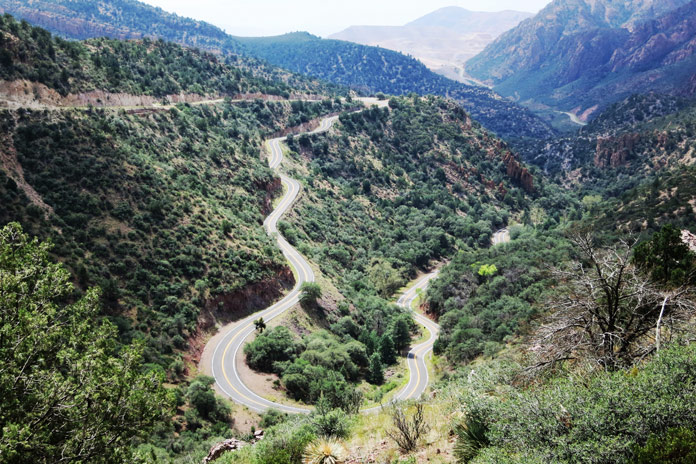
As I pull out onto the slowly drying tarmac, I know that I am in for the most entertaining portion of this high-country ride. After the meadow, the road is as winding as you will find anywhere. The first stretch is a wonderful ride through the wet, tall ponderosas. One of the great things about motorcycling is the direct connection to your immediate environment. In this case, that connection brings warming morning sunlight and the smell of damp forest.
With a reported 460 turns in 120 miles, the road is a survey in curve types. There are sweepers, banked, off-camber hairpins, and a few decreasing-radius eye-openers that require skill and restraint. I am riding on a road that demands respect but pays its rewards in grin-inspiring entertainment.
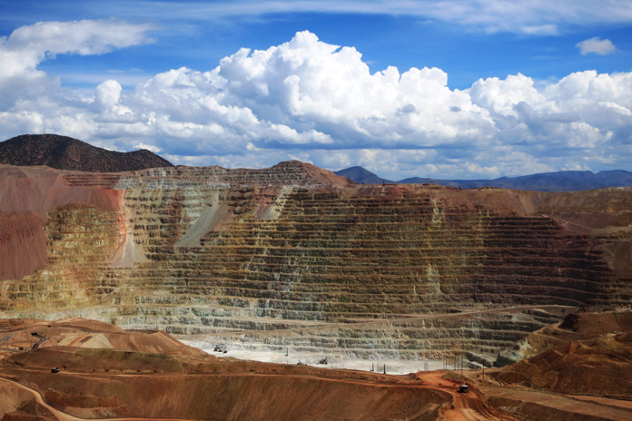
After miles of this alpine-forested moto-playground, I find myself on a serpentine descent into southern Arizona’s mine country. It is a stretch with true hairpins – the kind that have you searching for a gear lower than 1st.
The Coronado Trail cuts directly through working mines as it makes its way south. Gigantic rock carriers look like Tonka trucks in the distance as they traverse the stratified mine ledges in the quarries. The massive mines are, at the same time, awe-inspiring, strangely beautiful and innately disturbing. I ride through the pastel hues of the operation in complete amazement.
I end my Arizona mountain ride by rolling through the twin cities of Clifton and Morenci. Coronado may never have found those Seven Cities of Cibola on his quest, but I found a motorcycle mecca on mine. No, this is not the stereotypical Arizona portrayed on those cartoon maps – not at all.


