The Southern California Motorcycling Association produces an annual Best 15 U.S. Roads Challenge. The 15 roads are announced annually as the “collection” for that year, with some being retained from year to year. The entire distance of each road must be traveled between the locations listed for the road. The roads for each year can be taken in any order at any time during that calendar year. All miles (including getting to the challenge roads) must be completed on a motorcycle, trike or sidecar. Participants must be members of SCMA, and must assemble a logbook of the 15 roads that displays a photo in front of a recognizable point-of-interest at the start of each road and a gasoline receipt showing the date and time. For more information, visit http://sc-ma.com/rides/best-15-us-roads-challenge.
Author Bob Roger completed the Best 15 challenge in 2013 and, in this article, highlights his trip along each of the 15 roads in a logbook style.
My challenge ride began on July 3, 2013, with a trip to Waynesboro, Virginia, to the north end of the Blue Ridge Parkway. The next morning, I got an early start to ride the required 150 miles on the Parkway. This scenic highway follows the ridge tops, offering many panoramic views of the Shenandoah Valley on one side and row after row of the blue Appalachian Mountains on the other. Traveling around sweeping curves, through the woods and over the meadows, I saw numerous deer, a few groups of turkeys and even fox. The road is a casual cruise along the heavily wooded mountain ridges and, even at 35-45 miles per hour, the 164-mile tour to Floyd seemed to be complete before I was ready to finish. The Blue Ridge Parkway would be on anyone’s list of top 10 favorite roads.
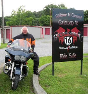
I continued my ride through Virginia and arrived in Tazewell by late afternoon. I was ready to begin my ride on the Back of the Dragon, also known as Virginia State Road 16, which took me 32 miles south to Marion. This road has great mountain-style twisties as it ascends and descends a couple of mountains on the way to Marion. Unfortunately, many of the tight curves have gravel on the road surface about halfway through the turns…very unnerving! If the locals want to compete with the Tail of the Dragon for motorcycle riders, they’ll have to keep this gravel off their road.
Speaking of the Tail of the Dragon, I rode that and the Cherohala Skyway the very next day. I started in Tallassee at the U.S. 129 Dragon Harley-Davidson, and rode the 11 miles and 318 curves to Deal’s Gap. The Tail is a unique road having so many curves in such a short distance. I’ve told friends who’ve wanted to ride the Tail of the Dragon, “Do not do so until you can operate all of your motorcycle controls at the same time!” The Cherohala Skyway is a very different ride from the Tail. It has sweeping curves and an elevation change of a couple thousand feet as you ride over the mountain from North Carolina into Tennessee, then on to Tellico Plains. It’s a more relaxing ride, not a white-knuckler like the Tail of the Dragon. They’re a nice contrasting combination of roads to ride together.
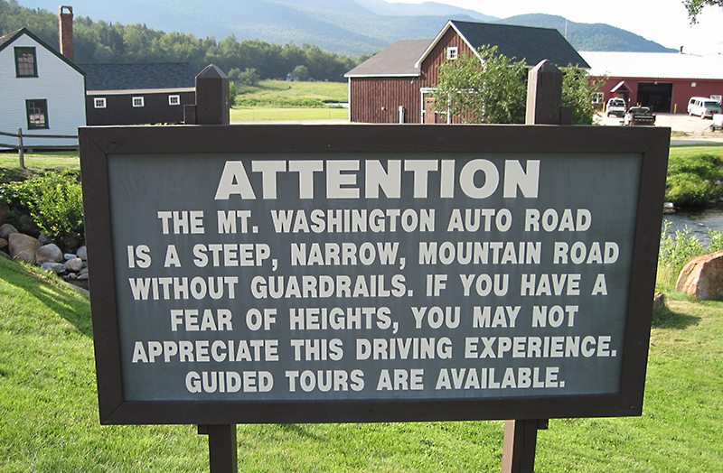
Unless you’re doing a Four Corners tour, the Kancamagus road group in New Hampshire is a little out of the way. I started up the hill from Wentworth, New Hampshire, on State Route 118, then rode down the mountain, through the tree tunnel, to North Woodstock and Lincoln. Here, the road name changes to State Route 112, the Kancamagus Scenic Highway. It’s an easy mountain road over Kancamagus Pass with great views of the White Mountains. From the pass, the highway takes you down to Conway and State Route 16. Mount Washington Road is a different story…it is a narrow, two-lane road, 1½ lanes wide, with no guardrails! The top few miles are not paved and the dropoff is very steep. This mountain road is not for the faint of heart, especially with its windy conditions! The rest of the ride north to Berlin was a breeze. I’m not sure why I had to ride any further after returning to “ground level” and coming out of the clouds of Mount Washington, but I did ride to Berlin to complete the prescribed route, and finished the challenge roads east of the Mississippi River.
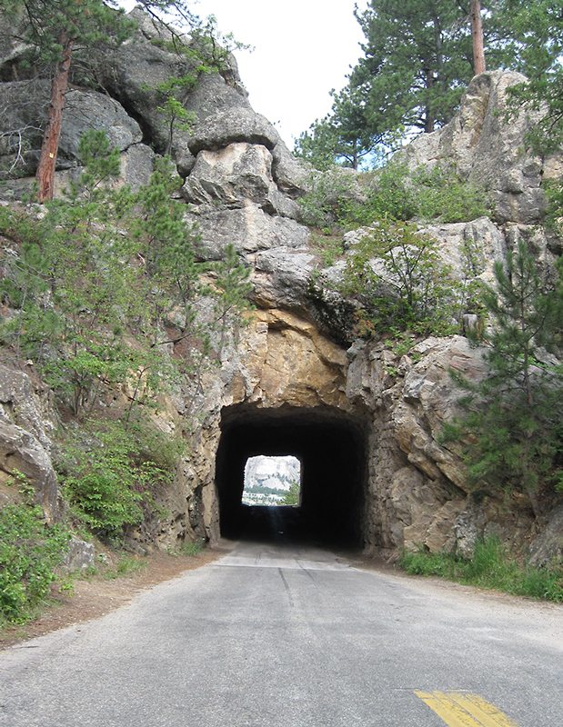
My western loop, to ride the 11 roads west of the Mississippi River, was to be my route to the sign-in for the 2013 Three Flags Classic. The first western road I encountered was U.S. Route 16A in South Dakota. Riding east from Custer, then north toward Mount Rushmore, I believe two of the three tunnels frame the presidents as you ride through, presenting a very impressive approach to the national monument. Unfortunately, I rode this one in the less preferred direction due to my overall ride plan. Not to disappoint the southbound traveler, the third tunnel also frames the presidents in this direction. I’ve ridden this road a few times before, and always love the ride through the pine woods with all the granite outcroppings. This is probably the best scenic road in the Black Hills and is one of my favorite roads.
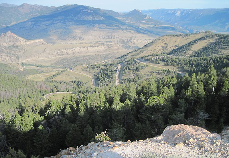
Onto Wyoming and the Chief Joseph Scenic Highway, which follows the Nez Perce Trail. I rode it in the opposite direction in which the Chief led his tribe. The view from Dead Indian Point was impressive, as I imagined how Chief Joseph guided them all up that steep mountainside, with just their horses to carry them and all they owned. At the end of the Chief Joseph Scenic Highway, a sharp right turn put me onto U.S. Route 212 toward the Beartooth Pass. Again, I’m riding in the wrong direction! Approaching the Pass from Red Lodge is much more impressive because of the steep climb. However, my ride up the mountain from Wyoming was still pretty spectacular, especially at the pass, which is alpine zone and all the rock is bare! The ride down the hill toward Red Lodge requires your full attention since those switchbacks are just as sharp in this direction. These roads absolutely belong on anyone’s top 10 list!
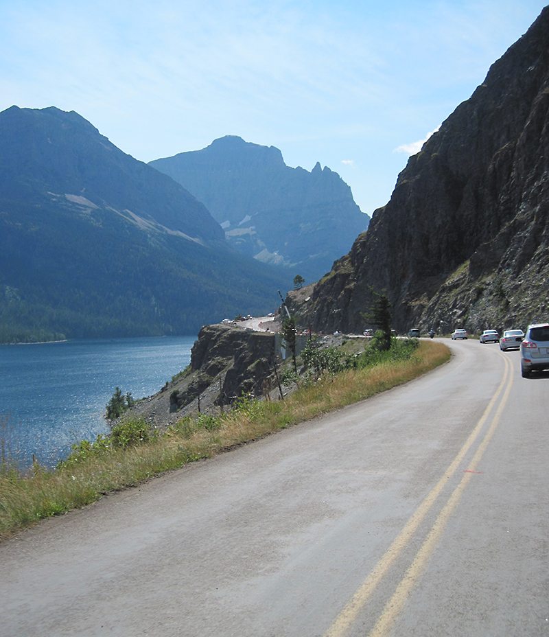
Tuesday, August 13, was a busy day at Glacier National Park in Montana and, with construction underway, the parade of cars moving through was slow. That was OK because the scenery along the Going to the Sun Road should be enjoyed. The large lakes on each side of the Continental Divide (at Logan Pass) are surrounded by spruce forests and high, bare rock mountains—some over 10,000 feet high! Glaciers are visible in many places on these mountains, and I even saw a big-horned sheep across the road from the visitor’s center at Logan Pass. This was a great ride through one of the most beautiful of our national parks!
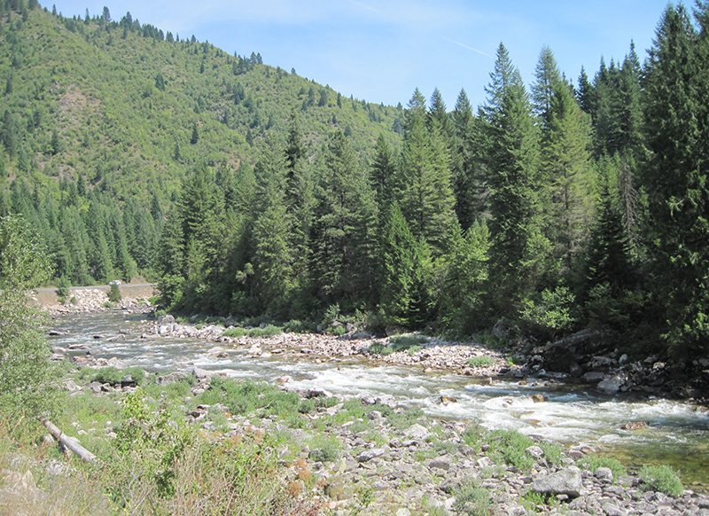
The next morning I left Kalispell early, heading south to Missoula and on to Lolo. I got gas and a photo, then headed west on the Lolo Pass (U.S. Route 12). I did have to stop for a photo of the 99 Miles of Winding Road sign, which some people might take as bad news, but I saw it as a blessing. I rode the curves along the Lochsa and Clearwater rivers to the Snake River in Lewiston, Idaho, finishing another of the 15 Best. Arriving in Lewiston at mid-afternoon, I decided to get a jump on the next day’s ride by continuing 120 miles to Spokane, Washington. This seemed like a great idea at the time, but I woke up in the middle of the night realizing that I had not taken a photo of myself crossing Idaho on U.S. Route 12! I knew I had to go back in the morning, so I rode at dawn. When I made it to Lewiston, I rode about 35 miles east on U.S. 12 to Orofino for the photo, then back to Spokane—300 miles later—by noon. I was a half-day behind schedule, but I had a nice morning ride!
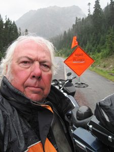
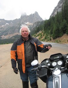
I made it to Omak by 3 p.m. to get gas. At the station, I spoke to a fellow Harley rider and learned that Washington Route 20 was closed due to a mudslide a few days earlier. To make a valid ride on the road, I needed to ride to the closure, supposedly 15 miles west of Winthrop. I had to ride 35 miles west of Winthrop to find the Road Closed sign at Rainy Pass (which it was). I had ridden 83 miles from Omak, coincidentally half of the 167 miles to Concrete, the required ride on Route 20. I returned to Winthrop for the night. The ride through the American Alps was worth the effort in spite of the rain and road closure.
The next day, I got gas and a photo of the “Welcome to Monterey” sign in California, then rode the Pacific Coast Highway south. It’s just a short ride through a stand of redwoods before the Pacific Ocean comes into view! The road then hugs the shoreline, through twisty curves. About halfway up the mountainside, the fog turned to clouds just above my head, exposing views of the ocean for the next 120 miles to Morro Bay. This road is another one of my top three favorites because it has woods, mountains, twisty roads and ocean views.
At sunrise, I started the day in Sacramento by jumping onto Interstate 80 east. Soon, I crossed over Donner Pass into smoke from a forest fire in Yosemite National Park. By the time I reached Lake Tahoe, the smoky fog almost completely hid the lake from my view. I stopped in Carson City, Nevada, for my ride beginning photo and gas receipt, then set out on “The Loneliest Road in America” into the desert in the smoky air. I rode to Austin, about halfway across Nevada, before the air cleared and I once again saw blue skies. I made enough of the required stops along the way to earn my “I Survived U.S. 50” certificate, and ended up staying in Ely that night. The next morning, I continued on U.S. 50 to Baker and the Great Basin National Park for a short visit. Next, it was on to Utah!
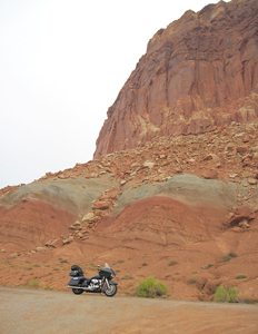
Utah Route 12 was the only road on the list that I had not ridden before. I knew about this road and have wanted to ride it for about 10 years. Over those years, the few times I’d been riding in Utah, I’d been in the wrong places to include Route 12. I had developed ideas of what this road would be like, but I found that I was way off. The road and the scenery were 10 times better than I’d imagined. Just when I thought I’d seen every possible combination of colors, sizes, shapes and textures of rock formations, I’d go around a corner and find another variation. I wasn’t sure why it was called the Grand Staircase as I didn’t seem to be changing elevation much, but then I came around a corner and found myself at the top of the stairs! The road was the highest surface in all directions, and there were steep drop-offs on both sides of it. I had never been on a mountain road that fell away on both sides! I am thankful that the road was fairly straight and level across the top. The varying rock formations and the breathtaking surprise at the summit absolutely make this road another one of my top three favorites.
After spending the night at the Americas Best Value Inn in Springerville, Arizona, I awoke rested and ready to ride. U.S. Route 191 begins with sweeping curves through the pine and spruce forests, with signs warning of elk crossing. As I got further along, the curves got tighter, finally becoming mountain twisties—very different from the start of the ride. At the end of these mountain curves and switchbacks, I came upon the Morenci Mine, a totally unexpected and very different scene. The copper mine has been in operation for about 100 years, and the size of the hole is indescribably large…the earth movers on the other side look like tiny toys, though their wheels are probably 10 feet in diameter. I continued on through town, then into more of a desert terrain. I made it to Three Way for gas and a photo to complete my ride on another of the 15 Best Roads. Don’t blink though, or you’ll miss this intersection called Three Way. With these different types of terrain, U.S. 191 was yet another great ride, and another favorite road!
Having completed 13 of the 15 Best U.S. Roads, I headed east on Interstate 10 toward Texas Hill Country to ride the Twisted Sisters! Leaving Van Horn, Texas, I spent most of the morning riding I-10. At Sonora, as I headed south off the Interstate, the drizzle started. I had light rain on and off for the rest of the day, but it was little more than an inconvenience. I did enjoy riding these Texas Hill Country ranch roads, each with its own character. My first encounter with one of the three Twisters Sisters was Ranch Road 335. With its undulating vertical changes, this road was like a roller coaster ride, while RR 336 was the ridge runner with many long distance vistas. Later, RR 337 was a cruise across the valley toward Medina, though she also contains sections with the attributes of both of her sisters. I saw another bighorn sheep on RR 337, but this one was a road kill and the main course for a dozen feasting buzzards. On RR 336, I was surprised to spot life-sized sculptures of an ostrich family of three, which was just before sighting a herd of ibex. The sisters are full of surprises—let them entertain you!
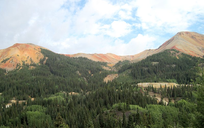
I started out of Deming, New Mexico, beginning Day 1 of the Three Flags Classic, a four-day ride to Winnipeg, Manitoba. The Three Flags Classic, also an SCMA offering, would allow me to incorporate U.S. Route 550, the 15th and final road on my list! I rode the nearly 500 miles to Durango, Colorado, before starting to document my ride on the Million Dollar Highway. I got my gas receipt and a photo before riding into the mountains. Views of the Rocky Mountains from this road are probably my favorite. The mountains, up to the alpine line, are covered with green spruce and pine forests with splotches of yellow aspen groves. The aspens were just starting to show their fall colors to add some contrast. The rocks were incredible too. I could not begin to describe the colors on Red Mountain Pass. The canyon into Ouray is also difficult to describe with its close, vertical walls and treacherous drop-offs. I made it to Montrose alive and, having ridden the length of the Million Dollar Highway, I completed the challenge of riding the 15 Best Roads. U.S. 550 is yet another of my 20 or 30 top three favorite roads!
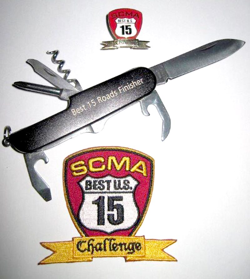
I’d ridden most of these roads a few times before, but including the 11 western roads of the 15 Best into one loop made this my ride of lifetime! Rewards for finishing the 15 Best U.S. Roads Challenge include a certificate, pin and patch. First-time finishers also receive an engraved pocket knife.
 |
 |


The finest motorcycle road I ever drove was Minnesota Hwy 210 through Jay Cooke State Park. 12 Miles of continuous turns and elevation changes with fabulous views of the St Louis river gorge. Portions washed out in 2012 when a foot of rain broke a dike. In their infinite wisdom, the state closed the hwy instead of repairing it. This route should have been promoted as a bikers destination, along with other nearby rides along Lake Superior and area forests.