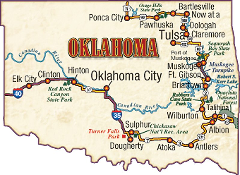
Upon entering Oklahoma, a decorative granite sign demarcates the state line, followed soon by a billboard depicting a Buffalo Bill character, waving his Stetson, astride a spotted horse rearing out of the sign in welcoming exhortation. My next stop was the Route 66 museum in Clinton. This so-called Mother Road became the highway of opportunity for Depression-era Oklahoma Dust Bowl refugees seeking renewal in the agricultural paradise California promised. During the formative period of the motor age, America’s Main Street came to symbolize a restless, freewheeling mobility.
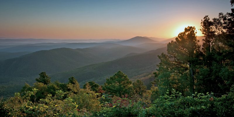
scenic views along the 54-mile drive. (Photo by Jason Wallace Photography)
- Near the outskirts of Hinton, a steep, hairpin-curved road drops into Red Rock Canyon, a hidden valley chasm sliced by a spring-fed creek flowing beneath soft, red sandstone cliffs. Climbers rappelled up their sheer faces. I found secluded camping among a fine old grove of hardwood trees.
- State Route 37 softly undulates with the landscape and occasionally curves in sweeping bends through wheat fields clinging to baked earth. Soon I came across an enduring symbol that has always sustained the Oklahoma economy, despite any erratic weather. A fully operational oil derrick turned and churned inexorably to extract the black, liquid gold that influences world markets and politics.

- I plummeted southward along Interstate 35 until I found myself in the Arbuckles—gentle, timeworn hills surrounding the Washita River. At Turner Falls Park, waders splashed in a circular swimming pool beneath the 77-foot cascade. I encountered Route 77D elevating high enough to allow broad views across the Washita River. This whiplash of road led me into Dougherty and the Arbuckle Lake region.
- While exploring near Fort Gibson I ran across twin iron truss bridges dating from 1926 spanning the Grand River. These girder frameworks were not unlike the numerous steel spans built along Route 66 to the north. I headed that way over glorious winding, wooded State Route 80 edging Sequoyah Bay.
Other Great Roads
- Talimena Scenic Byway runs from Talihina, Oklahoma, to Mena, Arkansas, and connects to the Oklahoma cities of Heavener and Poteau. Built in the late ’60s and completed in 1970, it was established as a Scenic Byway in 2005. It winds 54 miles along the crest of Rich Mountain and Winding Stair Mountain in the Ouachita National Forest. Along the drive are several historic sites and national park vistas overlooking mountain forestland at each glance. Talimena offers a variety of outdoor recreation opportunities, native plants and wildlife in a geological setting that makes it truly unique.
(This article is an excerpt from the article I’d Sooner Be in Oklahoma: A Motorcycle Journey Through the Past and Present, originally printed in the January 2000 issue. Tear it out and take it with you, or click here to print the PDF version.)
 |
 |


