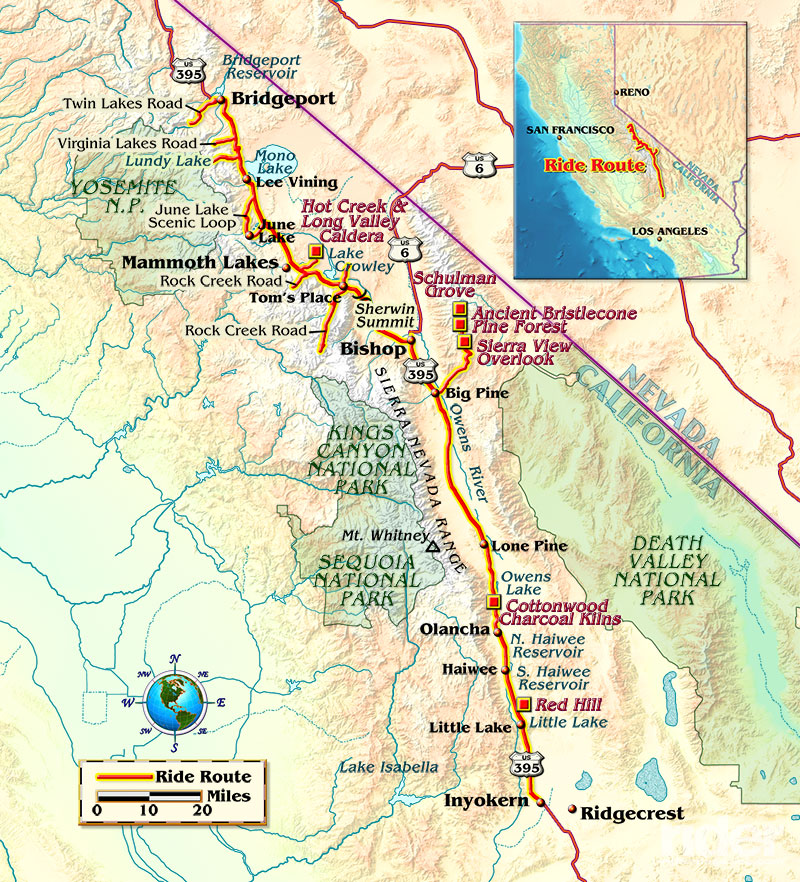
Most people ride U.S. Route 395 in California just to get from point A to point B, but wandering off the highway reveals numerous, rarely visited geologic and historic sites as well as seldom seen canyons with enjoyable winding roads and striking beauty. This journey seeks all of that in addition to a rare California sight: fall colors. Finding fall colors here can be like catching snowflakes. It helps to monitor a website, like
monocounty.org/fall-colors, that provides the percentage of color development at specific locations. Rather than forests of color, in California we tend to have scattered clusters that must be sought out.
Leaving Southern California in the early morning, I have about 200 miles to cover before joining U.S. 395 at the junction with State Route 14. Most of 395 passes through arid terrain paralleling the eastern side of the Sierra Nevada mountains. Pine forests occupy the passes north of Bishop, but below the passes there’s dry desert foliage. Incredibly, this mountain range is a single massive block more than 400 miles long, and is higher than the Rocky Mountains. It’s tilted somewhat, producing gentle western slopes and sharp vertical eastern faces.
Just past Little Lake is the Red Hill cinder cone and a sign for Fossil Falls. Here I take Cinder Road, which is initially asphalt but quickly transitions to dirt and hard washboard gravel before reaching an enchanting geologic site that hardly gets a glance from passing travelers. The eroded and polished whimsical shapes in Fossil Falls’ basaltic lava field were formed 10,000-20,000 years ago by glacial runoff and Owens River flooding. Geologists believe Red Hill is California’s newest mountain, created by numerous volcanic eruptions.
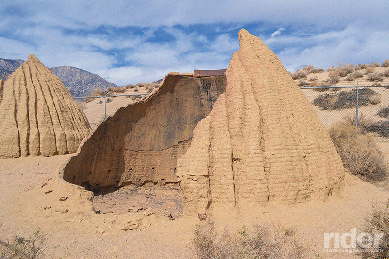
Saddled up and back on U.S. 395, I continue through the desert landscape. About 10 miles past Olancha there’s a sign announcing the Cottonwood Charcoal Kilns. A mile of dirt and gravel road takes me to the remains of two 1870s adobe brick kilns that produced charcoal for local smelters. The shore of Owens Lake once reached this high, but now the kilns sit high and dry. Be wary of this dirt road! I got stuck up to my rear axle in loose sand and needed help to extricate the BMW R 1100 R.
From the Kilns turnoff, U.S. 395 travels north through more desert countryside. Arriving at Big Pine, State Route 168 leads me to the Ancient Bristlecone Pine Forest. This road begins with a slow climb out of the desert valley up a wide canyon, eventually becoming a single lane that curves through a rock gorge and sparse stands of pine trees. After about 13 miles, the fun really begins on White Mountain Road. This well-maintained, two-lane asphalt road is like a sidewinder; sometimes wild and vicious and then quiet and tame. After eight miles, from the Sierra View Overlook I can see the Palisade Glacier. Five miles farther up, I get up-close and personal with some of our planet’s oldest living trees, the bristlecone pines, at Schulman Grove. Strangely, the return to U.S. 395 seems much easier and a short 15-mile cruise puts me in Bishop for the night.
Early the next morning I’m on 395 looking for Owens Gorge Road. This is a vast volcanic area called the Long Valley Caldera, formed 760,000 years ago by one of earth’s largest volcanic eruptions. Most of the material discharged over the six-day event formed Bishop Tuff. The Owens River cut through the deposit, forming the gorge and exposing the different cooling rate effects on the Tuff.
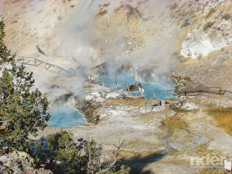
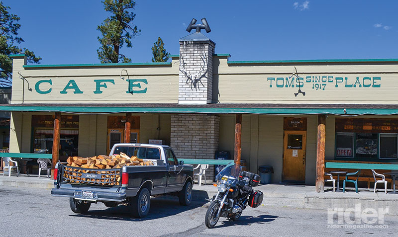
Seeking some canyon carving time, I head up Sherwin Summit looking for Tom’s Place and Rock Creek Road. It’s mildly curvy but rough, and 20 miles in and out provides some enjoyable fall scenery. Back on U.S. 395, I pull onto Convict Lake Road and stop at a glacially carved basin around Convict Lake rimmed with lovely yellow and orange trees. Then it’s back to the flatlands looking for Hot Creek Geological Site—a real challenge since there is no sign on U.S. 395. At Mammoth Airport, take Mammoth Airport Road, noting the sign for Hot Creek Hatchery. Following the hatchery signs and then Hot Creek Geologic Site signs and riding on 31⁄2 miles of single lane pavement and fair gravel road, you find the site’s steaming pools—another example of the eastern Sierra’s volcanic nature.
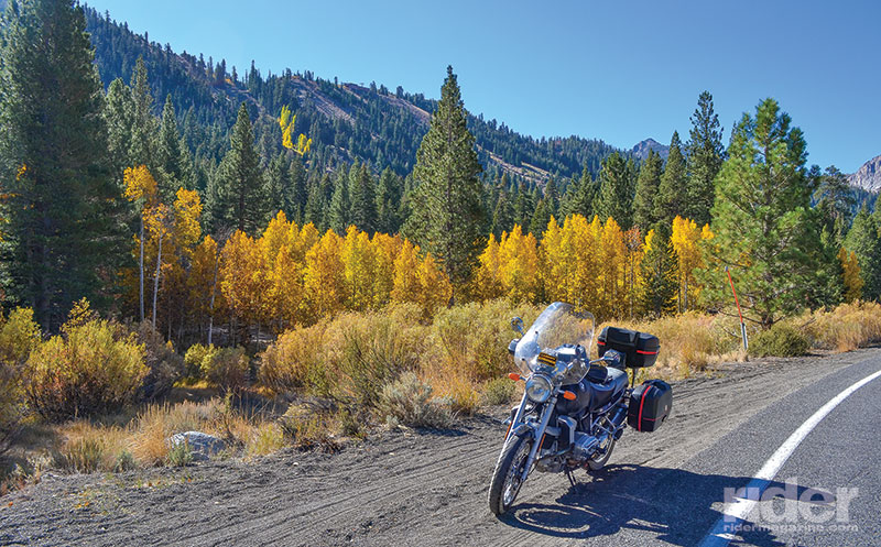
Relieved to be back on stable pavement, now I’m looking for the June Lake Loop—State Route 158. This is a low-speed scenic route of gentle curves through pleasant forests and an alpine town, offering grand vistas of the Sierra and several lakes. Aspens, cottonwoods and willows are in full color. The final stretch of Route 158 ends up in dry desert scrub. Seeking a step up in excitement, I head up Lundy Lake Road off U.S. 395. This pleasantly winding two-lane starts in high desert scrub and then ends up in scattered pines and colorful deciduous trees, with more awesome Sierra views at Lundy Lake.
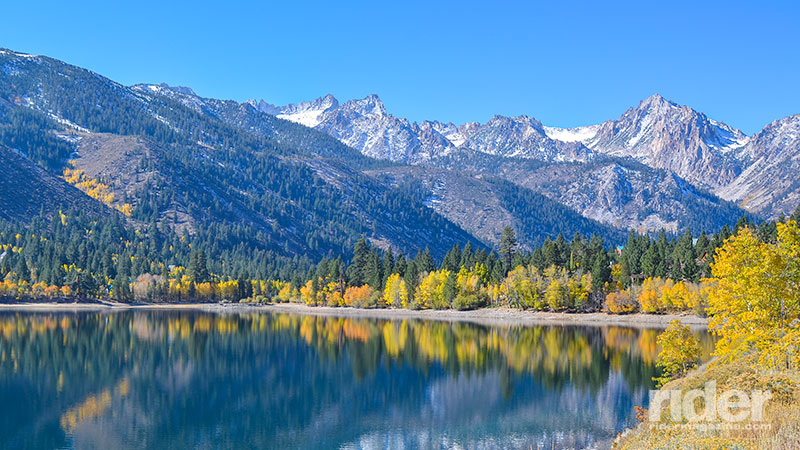
After a restful night in Lee Vining, Virginia Lakes is my next waypoint. Virginia Lakes Road is a laid-back canyon cruise through high desert foliage and occasional stands of pines, aspens and willows. Back on U.S. 395 riding for 30 miles to Bridgeport, Twin Lakes Road runs for seven miles past pastures of grazing cattle and then starts climbing up into Twin Lakes Canyon, swaying gently side to side for another six miles. Reaching the lakes, I find a beautiful glacially formed Sierra basin with mountain peaks reflecting in a lake rimmed by intense fall colors.
This ends my immersion in California’s rare fall color displays and my search for some unique and seldom-seen sights along U.S. 395—the Eastern Sierra Scenic Byway.


Don’t forget to stop at Manzanar……Japanese internment camp north of Lone Pine….then spend the rest of your ride wondering how FDR could have been such a raciest……..and how we still have people in power who would do the same thing…
Tom’s Place story: Late 1970’s, 21-y/o, riding north on US-395 to Mammoth from L.A., mid-October. and snow is on the ground at 7,000 ft. Just finished the Bishop to Tom’s Place segment going up the Sherwin Grade (4,000-6,500 ft.) as the sun set and the cold started. I was an hour late on the “warmth” schedule. It quickly became seriously cold. 65MPH wind chill at 45*-50*F is not comfortable without the right equipment! I did not have the right equipment. I was numb as I barely was able to get off my 1971 Honda 811 (punched out 750-no fairing) and walked into the bar. I immediately stood in front of the fireplace, shivering almost out of control. An older gentlemen offered to buy me a shot of Wild Turkey which I most gratefully accepted. This gentleman used to ride, as well. He clued me on the “old school” method for riding in cold weather: Newspapers! 45-min’s later I was warmed up enough, with newspaper stuffed around my legs and torso to help insulate them, I was off on the last 30-mile leg onto Mammoth. I was young and dumb. I didn’t know how to ride in the cold. I did some learning and I’m willing to pass it along in case anybody wants to know. Have fun out there!
That almost beats my story when I was 17 int thew early 80’s riding up to Big Bear in the dead of Winter on My Honda 500 with my buddy to ski, (We had Free lift tickets), no money and slept under the bridge in Summer sleeping bags and we froze our butts off all night in sub-freezing temps. Next morning we’re riding into town slipping and sliding all over the place on black ice, we go down doing about 25 mph sliding on our backs on the main drag…Ah the memories.