
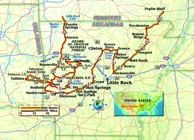
I’d been looking forward to burning up some hills and curves in western Arkansas, but for the moment I was riding a stretch of U.S. Route 67 that lay in the state’s northeast corner. The region is known for rice production, not peg grinding, but the flat, straight road has an interesting story. Designated the Rock ‘n’ Roll Highway, the name recalls the days when pioneers like Elvis Presley, Jerry Lee Lewis and Johnny Cash plied their trade in clubs, now long gone, that lined U.S. 67. The Beatles even made a surprise appearance in 1964 when their plane stopped at the Walnut Ridge Airport, an event that is celebrated to this day.
After another hundred miles of flat land, Arkansas Route 5 appeared on my map. The route is designated scenic by a series of green dots. Many roads in the state carry this honor and I spent the next few days chasing them.
Suzuki’s V-Strom 1000 is a fine traveling mount with good wind protection and comfortable ergonomics. On the minus side, my 2007 model has always felt a bit over-geared. Just before I headed out I replaced the chain and sprockets, with a rear supplied by the vendor that carried an extra tooth. The ratio change was nominal so I decided to run with it.
The Arkansas Department of Parks and Tourism distributes an excellent state motorcycling guide detailing 26 rides across the state, six of which are dual-sport routes. Route 5 is included in the Pinnacle Mountain/Greers Ferry Loop. As I entered the foothills of the Ozark Mountains, the pavement turned hilly with moderate curves. The road veers onto State Route 25 at Heber Springs, where things got interesting with tight corners and quick elevation changes.
A left turn at Drasco placed me on State Route 92, which intersects State Route 16 at the town of Greers Ferry. The 21 miles of twisties on the way to Clinton was the best sidewall-scrubbing run that I’d encountered thus far. I seriously thought about turning around and riding it again. Oh, and that single tooth totally transformed the machine. Corners that previously demanded a downshift were now handled without issue.
Just south of Clinton I jumped on State Route 9 and stayed with it to State Route 5 at Crows. I had to wonder if the town had been named for the coal-black scavengers that circled overhead searching out their next meal, generally armadillo carcasses which litter the highways. Hapless roadkill is soon reduced to its protective shell, the feast accompanied by squawks and screeches. Fast moving bikes need not worry, at least not about marauding crows anyway.
Further along Route 5, I found myself in the congested downtown of Hot Springs, site of the eponymous national park. This trip, though, was about discovering the road as opposed to points of interest, so I motored on through.
U.S. Route 70 skirts the southern edge of the Ouachita National Forest. On a lark, I diverted from the guidebook’s Diamond Run and veered west on State Route 84, and then State Route 246, which has plenty of grin-producing sweepers bending its red-tinted pavement. The smells were also amazing. Ouachita, like all of our national forests, is managed by periodic logging. The scent of fresh cut pine and cedar was overwhelming. Livestock production is also a major activity in this part of the state; fortunately the tree aroma acts as an air freshener.
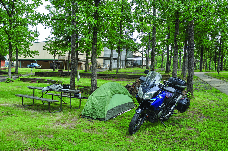
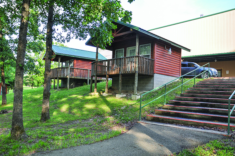
At Vandervoort, I turned north on U.S. Route 71, another fine piece of asphalt. With the sun dropping it was time to find someplace to pitch my tent. Hatfield is the headquarters of the Christian Motorcyclists Association. Since I’m a member, CMA’s Iron Mountain—a facility built by riders for riders—was the obvious choice. The sprawling grounds offer tent sites priced as low as $5.53 per night, with ride-ins welcome. Hot, clean showers and Wi-Fi are part of the deal. There are also a limited number of cabins and RV slots, but it is advisable to call ahead to check availability.
With a place to bed down, I rode to nearby Mena in search of food. At Stache’s Cookery I was treated to a grilled chicken sandwich platter smothered with bacon. The price was reasonable and it tasted good. There’s an outdoor beer garden with live entertainment on the weekends, and the Friendship Café offers homemade soups and baked goods served up with a smile.
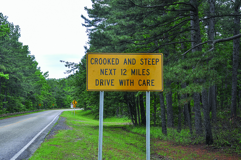
The next morning I set out for Talimena National Scenic Byway, or State Route 88, which snakes its way into the Ouachita Mountains just west of downtown Mena. Before getting underway, I stopped for breakfast at the fittingly named Skyline Cafe. A piece of small-town Americana, the diner features breakfast and lunch at ridiculously low prices. With my belly and the Strom’s tank full, we began the steep, turn-filled climb that gains 1,500 feet of elevation in 12 miles.
Getting down to business, I put the big V-twin through its paces, alternately rolling on the throttle and then pressing hard on the brakes. And though I was surrounded by spectacular scenery, Talimena Scenic Drive’s most arresting feature was not visual. Instead, a powerful wind, particularly at the top of Rich Mountain’s now retired fire tower, seemed to reach out and grab me. Weird as it may sound, the gusts collaborated with sparse traffic to make me feel like I was on one of the summits of the Alaska Highway.

The Ouachita Range is fairly unique as far as North American mountains are concerned, with an east-west orientation rather than the more common north-south alignment. At the Queen Wilhelmina State Park ranger station, I learned this was the main reason for the high winds.
Arkansas Route 88’s serpentine ribbon continues clinging to the backbone of the Ouachitas into Oklahoma. There its designation changes to Oklahoma Route 1 as it passes through the Winding Stair National Recreation Area. The name is accurate, and the ride every bit as exciting as the Arkansas side. A word of caution: someone went heavy on the chip-seal in places—slow down and stay upright.
A left turn on U.S. Route 271 soon found me at Talihina. There, I swung back east, picking up State Route 63 before heading north on U.S. Route 259, all good roads. U.S. Route 59/270 was my choice for the ride back into Arkansas. On a previous trip, I enjoyed exploring the Rich Mountain Country Store, a throwback to another time, but this time it was closed when I arrived. I consoled myself by climbing the short, steep Arkansas Route 272, which intersects Talimena National Scenic Byway for the ride back to Iron Mountain.
The next day’s objective was Mount Magazine, the highest point in Arkansas. Once again I took back roads, beginning with Arkansas State Route 8 to State Route 27, followed by a short jaunt on State Route 10. Finally, I entered the curves and hills of State Route 309, or Mount Magazine Scenic Byway, a top-rated run, but heavy fog above 2,000 feet obscured the promised stunning views.
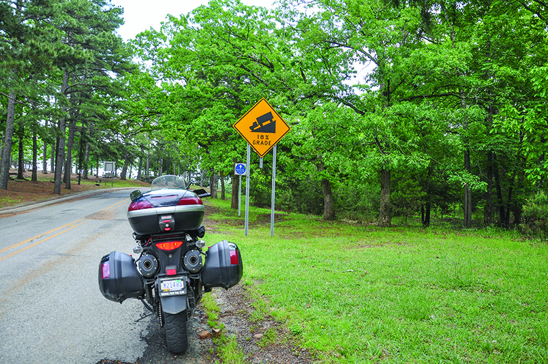
The loop continues with a right turn at Paris onto State Route 22. The friendly rangers at Queen Wilhelmina had recommended a short side trip on State Route 155 to Mount Nebo State Park. Young men with picks, shovels and strong backs accomplished much of the construction as part of a 1930s Citizens Conservation Corps effort. The park’s challenging access road gains 1,000 feet of elevation in only two miles through a series of 11 switchbacks scaling an 18-percent grade. Very impressive! After a trip back down the rollercoaster, I swung south at Dardanelle, again on Route 27, picking up State Route 28 for the ride back to Hatfield.
The Pig Trail Scenic Byway is the moniker applied to the entire stretch of State Route 23 from Boonville to the Missouri border. Unsurprisingly, businesses along the way capitalize on the road’s justifiable fame. In actuality, the true namesake covers a relatively short run deep in the Ozarks. One establishment at the southernmost end of the actual route, Turner Bend Mulberry River Outfitters, however, is a must stop. As a drop-off point for kayakers, food, fuel and road info are available. With the heavy rains Arkansas experienced last spring the last item could be especially pertinent, as periodic mudslides often close the road temporarily.
Since it was early May, the riding season was not yet in full swing. Nevertheless, I encountered more bikes on the Pig Trail than on all the previous routes combined. Not a bad thing, but something to consider if, like me, you enjoy the more solitary aspects of motorcycle travel. Another thing to think about is that Route 23 is a working road. Along with other motorcycles, you will encounter bicycles, numerous trucks ferrying kayaks and commercial vehicles like heavily loaded logging rigs, often in inopportune places such as tight turns and blind hills.
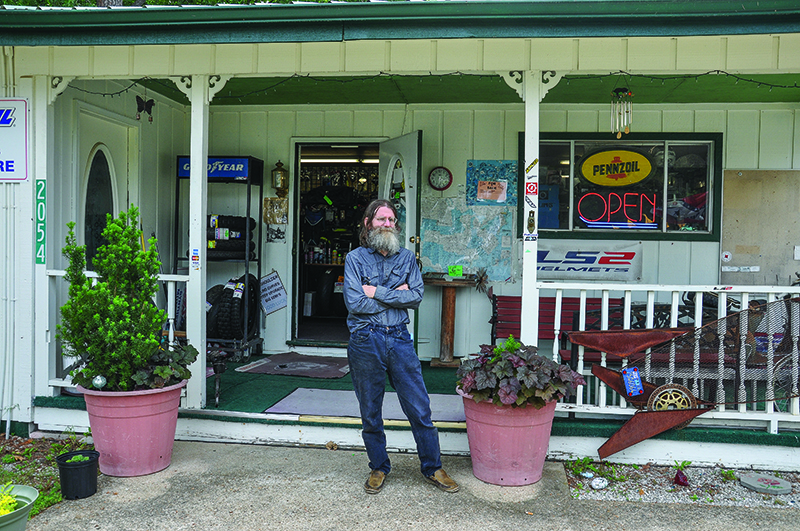
Since I was due in Kansas City, my plan was to gas up and hustle through Eureka Springs, the last town in Arkansas, but a bright yellow sign for Arkansas Adventure Rider convinced me to stop. A parts store and service oasis, the shop carries consumables such as tires, brake pads, lube and filters. Riding gear and luggage are also on display. Items not in stock generally can be obtained overnight. All makes and models are welcome and the shop’s owner, Larry, will do his best to get a rider back on the road.
I felt a sense of loss as I crossed the state line leaving Arkansas. The Natural State is a rider’s paradise, especially compared to my Northwest Indiana home, where we count the potholes per yard instead of curves per mile. Arkansas works hard to make riders feel welcome and I, for one, will be back.


I live in Poplar Bluff, Mo. and ride northwest Arkansas 2 or 3 times a year. You should check out the Buffalo river area in the Boston Mountain area.