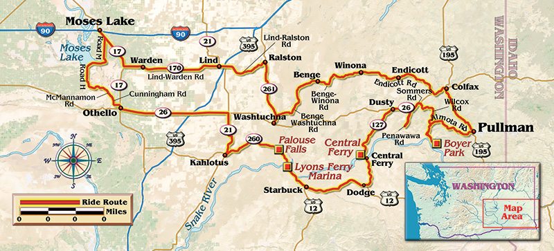
Fall…not my favorite verb, but definitely my favorite time of year for riding at the latitude where I live. Those of us who choose to ride “luggage challenged” bikes cannot find room to complain as tendrils of chilled air work through chinks in the cold-weather armor. It is a typical early fall day on the 47th parallel, where you wish you had one more layer in the morning yet will be sweating in your vented gear in the afternoon. Scents of decaying vegetation, burnt stubble and tilled soil filter in as the route heads south down State Route 17 looking for the turn east on State Route 170 to Warden, Washington.
This is a day for a spirited ride in a landscape filled with an array of colors and granola-like textures. Traveling the same roads across three distinct seasons treats riders to a variety of vistas painted with an entirely different palette. April through early June, fields of unripe wheat resemble plush, green velvet cloth blanketing the earth. During midsummer runs, July through August, fields of amber/golden grain wave in the breeze. Then come the muted browns and earth tones of fall, an ever-changing tapestry hung on the same undulating wall. Soon the first insects of the day hit the visor after passing through Warden, the site of a large new Canola oil refinery, as well as other long-standing food processing plants that lend their particular aroma to the day.

Rolling eastward now on the Lind-Warden highway, I encounter one of the straighter sections of the route with long, rolling spans that go on almost to the point of boredom, then thrust an unexpected off-camber corner at me or dip and rise so aggressively that it can send my front wheel clawing for the sky! Then there are the birds, often thickly flocked and flittering in the path or large enough that I need to duck…no pun intended. Hawks, owls, gulls, crows, magpies and others amass to enjoy the feast created by freshly disturbed fields and are quite active on this lovely fall day.
A quick jog south onto State Route 21 and I reach tiny, almost desiccated Lind, Washington. Many hard-working farm families keep the town on the map, along with the yearly event spectacle that draws thousands and answers that age-old question, “What do I do with my old combine when it is past its prime?” The Lind Combine Demolition Derby (lindwa.com).
Ambling eastward from Lind, just after crossing U.S. Route 395, do not miss the turn onto Lind-Ralston Road for a few more miles of fun before intersecting State Route 261 and turning south to Washtucna. The town takes its name from a renowned Palouse Indian chieftain, and it is hard not to think of those settlers and explorers of old, many mounted upon one of the famed Appaloosa horses provided by the Native American breeders (“Whatcha ridin’? A Palouse, huh?”).

Like virtually every township on this route, Washtucna has at least one gas station, tavern or other eatery where travelers can take care of their needs, and most are run by friendly, talkative locals. Though motel-type lodgings may be sparse, it wouldn’t be uncommon to be taken in for the night by total strangers if you needed shelter.
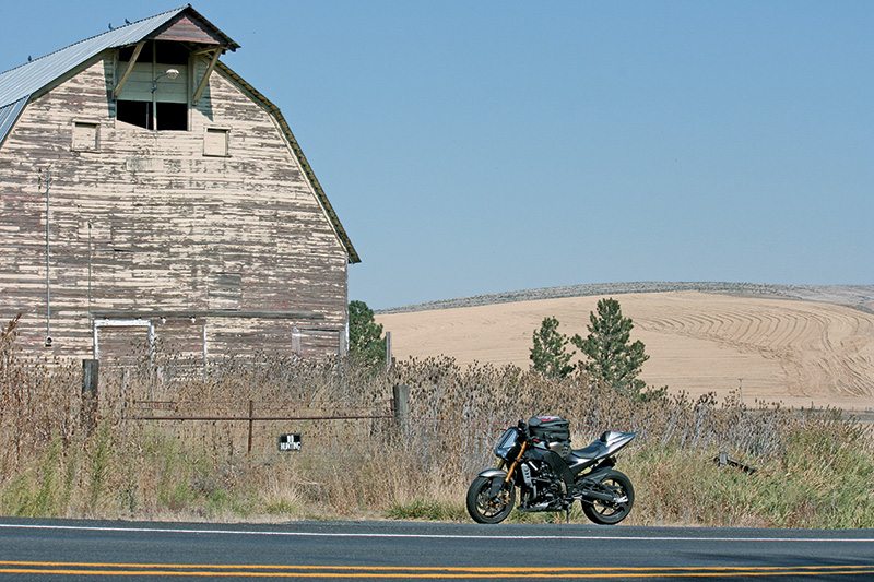
Doubling back just a couple of miles to continue east on Benge-Washtucna Road, I see many picturesque farmsteads both new and old, a virtual postcard of rural America. I am headed to my father’s birthplace, stirring thoughts of how past generations of my family carved out a life in this fertile, yet often harsh Palouse region. The terrain boasts even greater history here, with impressive signs of eons of glacial erosion and deposition, and evidence of the violent volcanic lava sea that created huge spans of the Channeled Scablands and basalt cliffs.
With a quick stop in Benge, where the only sign of life is a small grade school in recess, the path now becomes Benge-Winona Road. The macadam undulates for miles with enough alacrity to make me sad when it ends entering Endicott. With a living population of fewer than 300, I drop in to visit a few relatives and to take in the beautiful view from the hilltop cemetery through hazy, late-morning air. After bittersweet goodbyes, it is time to continue via Endicott East Road to the Whitman County Seat of Colfax, the largest town on this route.
20 minutes, one can see why State Route 261 is a fall Friday treat.
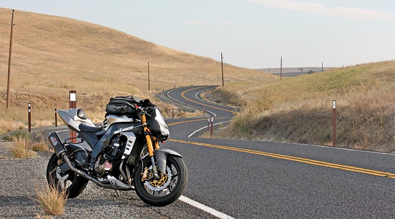
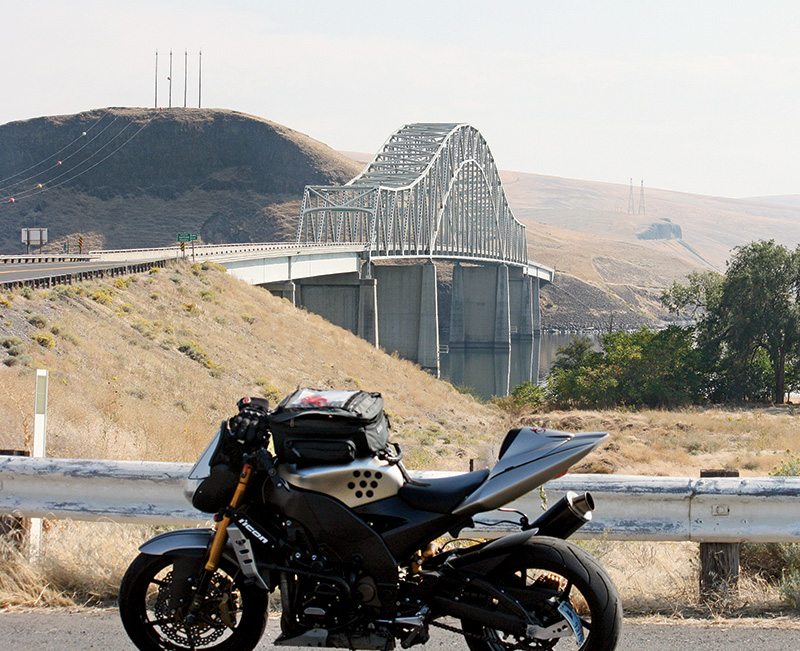
From the bustling burger joints of Colfax, I head south on U.S. Route 195, known for its high volume of hard-partying college travelers from the nearby state university, so extra alertness is warranted for these 14 miles. Just beyond the turnoff to Pullman is the turn west onto Wawawai Road/State Route 194, also known as Almota Road. This freshly paved cornucopia of corners twists and turns, bucks and rolls down to the Snake River’s serpentine banks. I need to be on my toes as there may be rivulets of spilled grain that can be like sand in the tight corners. Clawing playfully up and out of the canyon, the trail morphs easily into and onto Wilcox and Sommers Roads, and then intersects with State Route 26.
Continuing west on Route 26, I soon arrive at aptly named Dusty, Washington, where gas and food can be found while taking a breather before the next splendid section south on State Route 127/Central Ferry Road. Recently repaved, this stretch is exhilarating in scenery and fluidity, with well-placed passing lanes when you encounter occasional traffic; only two other vehicles share it with me today. As I slow for the crossing at the Port of Central Ferry, I might see pyramids of grain waiting to be loaded onto barges and sent downriver. Wind turbine giants sprout like steel and carbon fiber sentinels before reaching U.S. Route 12 and the shady rest stop named Dodge.
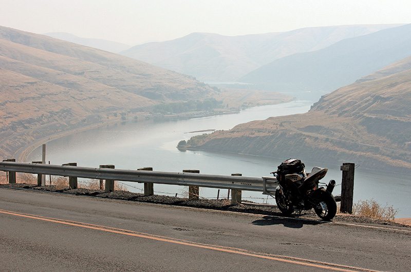
I need only ride a few miles westward on the much straighter and more heavily patrolled U.S. 12 before being rescued by the sign to Lyons Ferry and Starbuck on State Route 261. Sorry, no mega-chain lattes available here, just a road that narrows and coils with smooth, rolling pavement and pleasant vistas that stretch invigoratingly through fertile farmland that follows the lazy Tucannon River. Lyons Ferry KOA Campground and Marina is at the confluence of the Palouse and Snake Rivers. In season, there is a great restaurant open that offers a bit of a tropical flair when weather lends itself to outdoor fun, and they even have designated motorcycle-only parking.
Veering north again, I traverse water via another impressive metal span as Lyon’s Ferry Road/State Route 261 looms ahead, preparing for a nearly 1,000-foot rapid ascent out of the canyon. The road’s engineering keeps me on the sides of my tires most of the way even at a moderate pace. The surface is usually in fair-to-great condition, and traffic is light in this sparsely populated area.
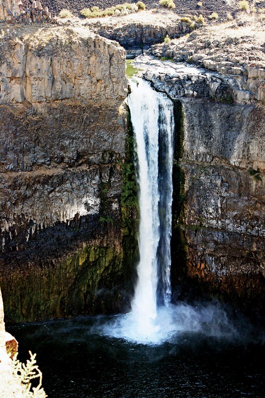
If time and inclination allow, visit the geological wonders at Palouse Falls State Park; a two-mile jaunt on well-graded gravel gets you there. While water volume varies greatly from spring to fall, with a near 200-foot drop, it has seen daredevil divers and kayakers take the plunge over its basalt barrier.
State Route 261 tees into State Route 260, so I bear west to tiny Kahlotus, where old meets new as a part of daily life. The ride now continues north via State Route 21 with a few delightful last twists out of a rifled arroyo and back to wide open wheat fields and flatness. Soon though, State Route 26 reappears in all her straight-laced fashion, and the next 28 miles west evaporate painlessly all the way to Othello.
Once northbound again on State Route 17, Cunningham Road is well marked as it wends travelers around Othello’s slow bits and takes them to the final leg of worthwhile riding on West McManamon Road. Weaving again through scab rock mesas perfect for a Hollywood western backdrop, I find the entrance to the Columbia National Wildlife Refuge. Home to an amazing array of creatures—birds, mammals and reptiles, many rare and protected—it provides a nice side journey for those armed with cameras.
I must leave McManamon at Road H to travel northward across O’ Sullivan Dam, one of the largest earthen dams in the nation that creates the massive Potholes Recreation Area and sand dunes of Moses Lake. One last turn onto Road M and it is straight to State Route 17 and home. With only minutes of useable daylight remaining, and 335 more miles on the odometer, the feeling deep in my soul is one of pure satisfaction, and of being more connected than ever to life.
(This article Palouse Wheatland Treasures was published in the November 2013 issue of Rider magazine.)
 |
 |


Great article!! What brand and model of Motorcycle is Ben riding???
Thanks!!!