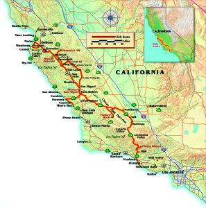
It’s 6 a.m. on a Wednesday as I head out of Port Hueneme, California, north to Monterey—the long way! There are so many fantastic back roads through this remote and pristine Central-Coast countryside that every trip is a unique and rewarding adventure.
Today, riding my BMW R 1100 R, I catch Highway 33 and head up what seems like a long, black snake winding through the scenic mountains of Los Padres National Forest. About halfway to the summit, leaving the patchy coastal fog behind, I have to deal with a blinding ball of sun through several curves. Once past Piedra Blanca, with the sun less of a problem, coveys of quail dart in front as I ride past chaparral and grassy areas around the Sespe Creek gorge. Cresting Pine Mountain summit, you can see down into Cuyama and Lockwood valleys, where the northern mountains at the western end of Lockwood Valley resemble a crinkled and wrinkled piece of paper in the early morning sun.

Reaching Cuyama Valley, Highway 33 becomes as straight as a string and I can stretch out and relax for several miles before breakfasting at Tina’s in Maricopa. Tina’s is like a funky truck stop without the trucks, and the food is good and plentiful. Sticking to 33 through Taft, I pass the oil rigs pumping black gold then pick up westbound Highway 58 at McKittrick.
Highway 58 starts out gentle enough, with wide sweeping curves that gradually tighten up, until I’m really pushing the bike over this serpentine road. By the time I reach Carrizo Plain I’m ready for some nice, straight road. There are still some fields of wildflowers and today I’m lucky to see a pronghorn antelope. Since this is the home of Carrizo Plain National Monument, history buffs might be interested in the rock paintings on Painted Rock, but right now it’s too early for the visitor center to be open.
Leaving Carrizo Plain, more curves bend through the lovely Central Coast heartland of oak trees, grassland and ranches. Reaching La Panza Road, I head for Paso Robles. La Panza runs through cattle and horse ranches plus a scattering of vineyards. It ends at Highway 41, where it becomes Creston Road. I gas up at Paso, but save my appetite for the world’s best creamy, red clam chowder at Phil’s Fish Market in Moss Landing, north of Monterey.
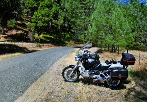
A little north of King City the truck and auto traffic starts building, so at Gonzales I take the Gloria Road exit, pass over 101 and pick up Gonzales River Road to cross the Salinas River for a leisurely ride up River Road (G17). This sedate back road runs north all the way to Highway 1 at Marina, which takes me just south of Moss Landing and my favorite lunch.
After a night in Monterey and a tasty breakfast at the Black Bear Diner, I pick up Highway 68 heading east. Traffic is light; everyone seems to be going to Monterey. Dropping off Highway 68 at River Road (G17) and heading south, the traffic melts away past the housing development and soon I’m by myself enjoying the rhythms of the sweeping curves. This is farmland, first with fields of vegetables and strawberries, then endless vineyards. My only concern is the slippery mud that the farm vehicles occasionally track onto the road.
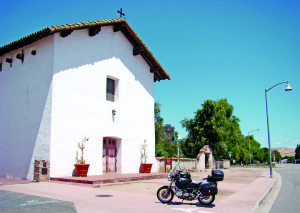
Then a surprise, a huge field of prickly pear cactus surrounded by the vineyards. There’s no one around to ask about it, so the mystery remains. G17 changes to Fort Rome Road and passes the Mission Soledad. I’ve never visited but the gate is closed, so I can only take a picture from the road. Fort Rome Road ends at Arroyo Seco Road, where a left gets me over to Highway 101 for a short northern hop to Soledad.
Following the signage, I pick up Route 146 heading east from Soledad toward Pinnacles National Monument. Before continuing south, riding up a narrow country road takes me to this lightly visited park. The volcanic formations of the Pinnacles are actually part of an ancient volcano that split apart, riding the Pacific plate northward to the park’s present location. The remaining volcanic formations are 195 miles south at the Neenach Formation around the Gorman (Interstate 5) region.
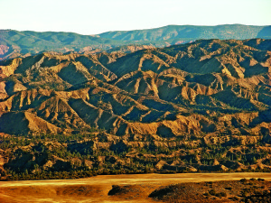
Backtracking out of Pinnacles on 146 (the only road in and out), Metz Road (G15) runs south all the way to King City. G15 is a real treat—a smooth two-laner full of curves and practically devoid of traffic. Cruising along, there are lovely panoramic views of the Salinas River valley—the vegetable bowl of California. At King City, Metz Road runs into 1st Street through the back of town. I look for a gas station because there won’t be any services for the next 70-plus miles of back road.
Lonoak Road runs east from King City, and after a short distance turns into a very narrow road with no centerline. The farther I go the more deserted the countryside gets, full of cattle ranches in the Old West tradition. The back and forth of the curves, the beautiful golden grassland and total remoteness are mesmerizing. Once past San Benito County, the road surface changes from smooth blacktop into a mosaic of patches laid on top of patches. Now I’m watching out for potholes as I’m leaning through the curves. After a while, I’m ready to stretch out on the highway pegs. Highway 25 is just the ticket—a wide, smooth two-laner full of relaxed curves. And best of all, I’m pretty much by myself again—and truly thankful for weekdays!
Reaching Highway 198, a very short jog east takes me to Peach Tree Road. Once again I’m in beautiful, deserted cattle-grazing country. Peach Tree quickly turns into another narrow road in rolling hill country. I can see through the curves and don’t have to worry about being surprised by oncoming traffic. As the only wheels out here today, there is little to see on the road, though I am surrounded by cattle.
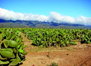
Peach Tree Road ends at Indian Valley Road, where the ride gets challenging for me. Indian Valley is even narrower and runs through lightly forested, semi-mountainous terrain. Even though I seem to be the only vehicle on the road, there could always be a big ol’ dually around the next curve.
Indian Valley ends at Cross Canyons Road, where I ride over the Salinas River and arrive at San Miguel, where Mission San Miguel is located. It’s been closed for repairs for a while, but dates back to 1797 and is noted for the arches in its vaulted corridor. After a walk around the Mission to stretch out the old joints, I head south on Highway 101 to pick up Highway 46 west over to the Pacific Coast Highway. There, a leisurely cruise south ends in Morro Bay for one more night on the road before heading home. Over dinner, I can’t stop thinking about the last two days of riding on the incredible deserted and winding motorcycle roads of the Central Coast. Best of all, there are many more of these roads for me to enjoy!
(This Favorite Ride: Central Coast Ramble was published in the October 2012 issue of Rider Magazine.)

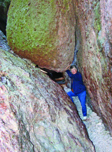


The cactus is probably being cultivated for the “paddles”, known as “nopales”…..very popular in Mexican cuisine….as well as the fruit of the cactus, also very tasty…