I’ve eyed it longingly on countless trips on Interstate 70 across the Colorado mountains. The sparsely traveled two-lane winds its way alongside the interstate, at times close by, at times across the valley, and sometimes unseen. Blasting along at 75 mph, the relaxed pace of the two-lane calls out, evoking images of bygone days, days I can remember. These are remnants of old U.S. 6, now largely abandoned for the interstate. Once it was the longest highway in the country, stretching east to west from Provincetown, Massachusetts, to Long Beach, California. How much of it survives between Denver and the Utah border? I decided to find out.
Heading west out of Denver, the interstate avoids the narrow, rocky incision of U.S. 6 up Clear Creek Canyon, climbing instead through nearby Mount Vernon Canyon. So along this surviving stretch, red rocks tower overhead, the stream crashes its way down, and the road twists and turns with the water. At times, big horn sheep graze on the hillsides, unconcerned with the humans who pull over with cameras.

Meeting I-70 just east of Idaho Springs, I got onto the big road for a short distance. At Idaho Springs I was right back off, following Colorado Boulevard/Old U.S. 6 through town. To my right was the Argo Mill, where gold ore once was brought for stamping and extraction. With its machinery intact, and sitting atop the huge tailings pile it generated while in operation, the mill is open for tours and answers to your questions about mining in the area.
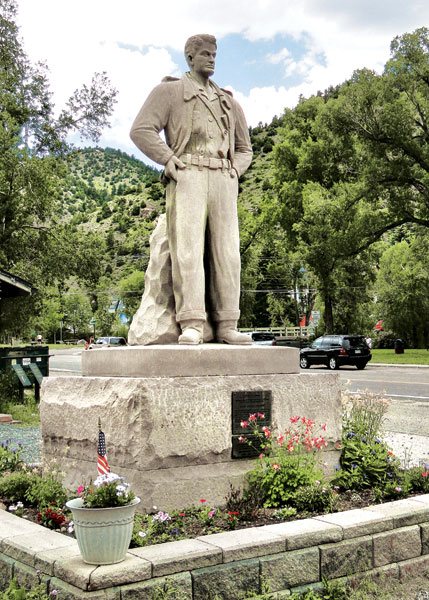
Just across from the Argo Mill stands the Steve Canyon statue, reputedly the first ever statue to honor a comic strip character. Unveiled in 1950 as part of a move to rejuvenate Idaho Springs’ Gold Rush Days celebration, it was dedicated as a memorial to all servicemen. Nearby Squirrel Gulch was also renamed Steve Canyon.
Continuing west to Georgetown, the old U.S. 6 roadbed survives as a 12-mile, two-lane alternative to the interstate. Georgetown itself is a well-preserved Victorian town that gives you an idea of mountain living in a bygone era. At George- town the interstate was cut through the mountainside on a direct route up to Silver Plume, climbing 600 feet in approximately 1.5 miles. Old 6 went through Georgetown, deep into the crevice of the canyon, at which point two switchbacks lifted it up to Silver Plume. Only pedestrians and mountain bikers can take those switchbacks now, but the road is open to their base, where you can board the steam-engine-powered Georgetown Loop Railway. This reconstructed railway was originally built to loop back upon itself in order to make it up the steep, short climb.
I exited I-70 at Silver Plume, and followed winding U.S. 6 through the trees on the opposite side of the creek from the interstate. Much of the time the new road is invisible and the nearly deserted piece of two-lane called for me to relax and enjoy the ride.
Rejoining I-70 four miles later, it’s another six miles to the Loveland Pass exit, where one of the best parts of the ride awaits.
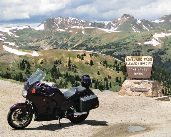
While the interstate bores through the Continental Divide here via the Eisenhower Tunnel, U.S. 6 climbs and crosses this 11,990-foot pass. The steep eastern side features numerous switchbacks and breathtaking views down to where I had just ridden. When riders heading for Colorado ask me for routes I tell them, “Don’t take the tunnel. Loveland Pass is one of the reasons you’re coming here.”
Once over the top the road drops in less dramatic fashion down through Keystone Resort and to Dillon, where it again meets I-70.

The old route of U.S. 6 and town of Dillon were inundated when Lake Dillon was constructed in 1961. The town and highway were relocated to what became the north shore of the lake. The interstate came through three years later. Instead of I-70 I chose the road across the dam that carried me to Frisco, and I picked up the slab there.
It was a jolt to suddenly be back in traffic moving at speeds nearly double what I had become accustomed to. Nothing remains of the old road as I-70 leads up to Copper Mountain and over Vail Pass. That’s not to say this is an unpleasant part of the ride. We who live in Colorado tend to forget that in the mountains, even the interstate is gorgeous. And the road over Vail Pass, especially, was designed with beauty in mind.
I blasted over the pass, down through the Vail Valley, and exited at Minturn, leaving the interstate entirely for 35 miles. Initially U.S. 6 runs below the interstate, close to the banks of the Eagle River, but at Avon it brought me directly into the busy and congested down-valley sprawl of Vail. Past Edwards, however, I was once again on a two-lane following the river. As the high-speed traffic blasted along on the big road above, I relaxed and enjoyed the calm of the old road.

The perfect spot for lunch was just up ahead and I was ready for it. Right where CO 131 takes off from U.S. 6 at Wolcott sits the Wolcott Yacht Club. A favorite for riders, the Yacht Club offers dining inside or outside in its spacious, shady beer garden. Fortuitously located in a spot where numerous popular day rides converge, on summer weekends motorcycles easily outnumber everything else here.
I continued west from Wolcott through Eagle and Gypsum, with U.S. 6 holding close to the river and the interstate always “over there.” Again I was transported to the days before the interstate when we used to cruise this beautiful route along the Eagle River.
At Dotsero I-70 plunges into Glenwood Canyon, where there was no room for two highways. Thanks to environmentalist opposition to just gouging the interstate through, this is perhaps the most spectacular portion of interstate anywhere in the country. The battle ran for decades, with the result that this was the final portion of the original interstate system to be completed, and the road is a marvel of engineering and is itself a thing of beauty. Plus, winding as it does through the narrow canyon, the speed limit is reduced to my easygoing pace.
Bits and pieces of old U.S. 6 do exist through the canyon, accessed via the several exits along its length. The largest piece is at the No Name exit, where a turn to the west takes you looping along the riverside, to a point where motorized traffic is halted. Pedestrians and bicyclists can continue on up around a bend to where what is now the bike path meets up again with the interstate. It’s an extremely pleasant and interesting walk, but personal experience says don’t do it in motorcycle boots.
Back on the slab, a few more twists in the canyon brought me into Glenwood Springs, where the world’s largest outdoor hot springs pool beckons to weary travelers. This was not my stop though, and I picked up my speed along with the other traffic until the canyon widened at Chacra. I left I-70 and it would be another 45 miles before I needed to get back on it.
Along the stretch from Chacra through New Castle and Silt to Rifle, the Rifle Valley opens up and the interstate disappears off to the south while the old road hugs the northern hillside. Except for the occasional modern building, the old structures and the old road could have persuaded me the year really wasn’t 2010, but perhaps 1960.
West of Rifle the old highway is little more than a frontage road for the interstate and the terrain is dry and western, with sagebrush the most common vegetation. Two years ago coming through here there was a forest of oil rigs on all sides, and finding a motel room was an impossibility, as oil field workers claimed every available unit. Today the rigs are gone, but the landscape is now dotted with the pumps and storage tanks that are the drillers’ legacy.
At De Beque I was once more forced onto the big road, as old 6 totally disappears for the last time before reaching the state line. Through De Beque Canyon the eastbound and westbound lanes diverge, with the river in between, and herons’ nests fill the upper branches of the tallest trees. Many times I’ve followed old U.S. 6 through this canyon on what is now the eastbound lane of the interstate, watching the progress of highway construction across the river.
As the canyon’s mouth opens into the Grand Valley, U.S. 6 slips away from the interstate and I was soon riding through acres and acres of fruit trees and grapevines. Palisade, just up ahead, is the center of Colorado’s fruit industry. In season, stop for one of the best peaches found anywhere. In recent years vineyards have sprung up and tasting rooms now dot this fertile valley.
A straight run paralleling the railroad carried me into Grand Junction. In the downtown area the road and I hooked northwest and out, on to Fruita, to Loma, and to Mack, the last town before the border. The map and the signs say that U.S. 6 terminates at Mack, but in fact, the old road continues west. Ten miles farther on this lonely, deserted road and I reached Utah, where a dilapidated, gunshot monument marks the state line.
This road goes on to Green River, but while the pavement is smooth and well-maintained on the Colorado side, on the Utah side it appears not to have seen maintenance in 40 years. Proceed with caution.
For me, it was time to return to Grand Junction, to spend the night with a brother. The next day I retraced this whole-day trip in just a few hours at freeway speeds. Can you cross the Colorado mountains on old U.S. 6? With a few key exceptions the answer is yes, and it’s far more pleasant than the alternative. My eyes and memory did not deceive me when those two-lanes beckoned. And if the journey is the destination, this is a journey worth taking.


Much of 1971 movie “Vanishing Point” was filmed in Glenwood Canyon and along U.S. 6, Colorado & Utah.