story and photography by Gary Ilminen
[This Favorite Ride was originally published in the December 2010 issue of Rider magazine]
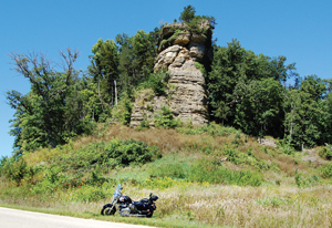
From Sauk City to Prairie du Chien, Wisconsin, the road and the river take you to another time and place, with great side trips along the way. The Lower Wisconsin Riverway is a very special part of North America that traverses what is known as the “Driftless Area” of southwest Wisconsin. It is unique because the glaciers of the ice age surrounded, but did not cover it. Instead, the runoff or “outwash” from the melting glaciers sculpted layers of sandstone into the kind of spectacular rock formations usually associated with the desert Southwest.
From Sauk City to Prairie du Chien, a distance of only about 72 miles, the Riverway offers soaring sandstone formations, prehistoric Native American effigy mounds, battlegrounds from the Black Hawk War, preserved vestiges of the lead mining days of the 19th century and family dairy farms that predate the Civil War. It can be enjoyed as a day trip or soaked up slowly over several days.
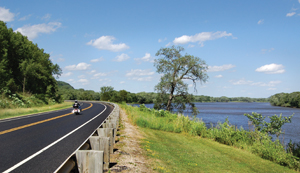
State Highway 60 is the centerline of the tour, clinging to the banks of the Lower Wisconsin River. South of the river’s broad valley, side roads ascend to the state’s rolling uplands where endless sky and hilltops seem to make everyplace downhill from wherever you are. North, the Kickapoo River follows its tangled route through the steep redoubts of the Ocooch Mountains. The Wisconsin River ends at its confluence with the Upper Mississippi River in a vast canyon of sandstone bluffs a couple miles wide.
At its western end, Highway 60 joins State Highway 35, known as the Great River Road, which is a National Scenic Byway. Six miles west of Sauk City, following Ferry Bluff Road a half mile takes you to a small parking area at the foot of Ferry Bluff. It is a walk of only about 800 feet to the top, and the last 300 feet are steep, but the view is worth the hike.

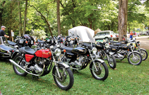
Eleven miles north from 60 along County Highway C lies the tiny hamlet of Leland, which is the end point of the Slimey Crud Café Racer Run. The Crud Run happens on the first Sundays of May and October, beginning at Pine Bluff in Dane County. Usually drawing anywhere between one and two thousand riders, the Crud Run is probably one of the country’s largest spontaneous, nonsponsored motorcycle rallies.
Less than a mile out of Leland northeast on County Highway C lies Natural Bridge State Park, home to one of the state’s two natural bridges. The natural bridge soars about 35 feet overhead and its arch spans about 25 feet. Take the trail to the left from the parking lot a quarter mile and step back in time thousands of years.
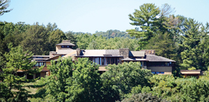
Twenty miles west of Sauk City, in Spring Green, U.S. Highway 14 and Highway 60 join near their intersection with State Highway 23, which runs south past Taliesin, the northern estate of enigmatic architect, Frank Lloyd Wright.
Continuing west on 60, U.S. 14 splits off to the northwest at Gotham, home of—you guessed it—the Bat Cave Bar. For those who like to take some of the antique feel of the area home with them, an excellent shop called Yore is at the intersection of Highways 14/60 and County Highway JJ in Gotham. Following Highway 14 10 miles to State Highway 80 and following 80 north to Rockbridge brings you to Pier Park. Here you can check out the second of Wisconsin’s two large natural bridges and walk about 70 feet through a cave that runs through the stone to a footbridge that crosses the Pine River.
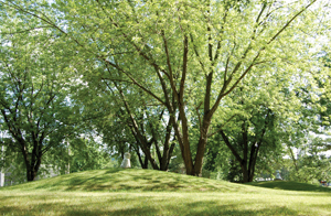
If you continue west out of Gotham on Highway 60, you’ll enjoy some moderately technical riding along one of the curviest sections of the route. About eight miles west, just past the intersection of 60 and State Highway 80, lies an ancient Native American effigy mound in the shape of a bird. Visible from the highway, it is worth the walk along the footpath that starts at Effigy Mounds Drive.
Highway 60 straightens out from here west, but offers a number of great spots to stop and view the Wisconsin River up close; the boat landing at Port Andrew and the wayside just east of the junction with State Highway 61 are especially good ones.
Crossing the river south on Highway 61 to Boscobel, there are a number of small cafés to stop at for a meal, and if you hit town in the first weekend in August, you can bear witness to the Civil War. The weekend-long “Muskets & Memories” includes a military encampment and large-scale reenactment of Civil War battles.
About six miles east of Bridgeport on Highway 60 lies a small wayside that includes the Cipra Effigy Mound Group of three linear and six conical effigy mounds, some only a few feet from the edge of the paved parking lot. Though no one is certain of the purpose of the mound structures, it is known that conical mounds most often were burial sites, having been found to contain human remains. Linear mounds or those in the shape of animals or man generally don’t contain remains, so they may have been for ceremonial purposes.
Highway 60 joins state Highway 35 at Bridgeport, and turning north takes you to Prairie du Chien, one of Wisconsin’s oldest Mississippi River towns.
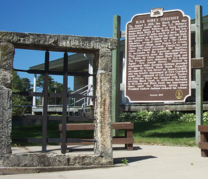
It was here at Fort Crawford in 1832 where Sauk warrior Black Hawk surrendered to government officials, marking the end of the bloody, summer-long Black Hawk War. The Fort Crawford site survives today with a museum and stone and iron window from the prison cell where Black Hawk was imprisoned.
From Prairie du Chien your route can continue west on U.S. Highway 18 to the antebellum towns of Marquette and McGregor in Iowa or north 35 miles to Victory, Wisconsin, near the mouth of the Bad Axe River. The Battle of the Bad Axe ended the Black Hawk War of 1832, after the bloodiest two days in the history of what would eventually become the state of Wisconsin. About 400 of Black Hawk’s followers, including women and children, died here. Today, a lone marker stands on Battle Island in the Black Hawk Recreation Area to commemorate the event.
Some of the most expansive views of the Upper Mississippi River Valley can be had by crossing the Mississippi River on U.S. Highway 82 west to Lansing, Iowa, from the park high atop Mount Hosmer in Lansing.
Whether you continue west into Iowa or Minnesota, go north or south along the Mississippi or loop back east, touring the Lower Wisconsin Riverway is a great ride that can be enjoyed again and again.
More information:
Eagle Cave on Eagle Cave Road (Site of the annual British Biker Cooperative Rally)
British Biker Cooperative Rally information: www.britishbiker.net
Mount Hosmer (Lansing, Iowa), www.lansingiowa.com
Muskets & Memories (Civil War Era Reenactments in Boscobel, Wisconsin), www.musketsandmemories.net/index.html
Natural Bridge State Park, County Highway C, near Leland, Wisconsin www.stateparks.com/natural_bridge.html
Prairie du Chien, Wisconsin, Chamber of Commerce/Scenic Motorcycle Roads Touring Guide, www.prairieduchien.org
Taliesin ToursT(Frank Lloyd Wright estate near Spring Green, Wisconsin), www.taliesinpreservation.org


