by Scott A. Williams
photography by the author and Gregory R. North
Lots of riders (your humble scribe included) have added GPS to their motorcycles. While I’m truly enjoying satellite navigation with turn-by-turn directions, hundreds of MP3 selections and thousands of points of interest, I did manage just fine for years without all that.
The desire to explore has taken me far, but a willingness to seek out local knowledge takes me places I may never find otherwise. Chatting with a police officer in Vermont, I learned about local roads that maps show as dirt but which are paved and carve through the mountains. Over tea with an innkeeper in Nova Scotia, I learned about the waterfall beyond the picnic grounds that isn’t mentioned in the guidebooks.
Stopping to ask the locals, “Where’s a good place to eat?” keeps me out of chain restaurants. More importantly, it gives me an opportunity to ask a fellow diner, “Do you know where this wiggly line on the map goes?” GPS guidance has failed me more times in a season than suppliers of local knowledge have since I bought my first motorcycle 24 years ago.
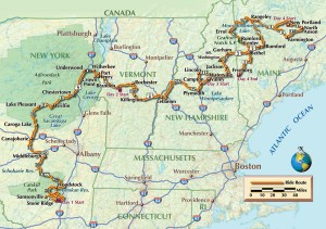
This approach to finding my way on two wheels spawns an idea: Bring together experienced riders to share their own brand of local knowledge on a multiday excursion through each other’s neck of the woods. The plan grows to include four states in four days—a sort of Northeast “Grand Slam”—as some riding buddies join me along byways and backroads in eastern New York, northern Vermont and New Hampshire, and western Maine.
On the appointed day, riders from five states converge on New York’s Hudson River Valley. This is Carl’s home region and his knowledge of local backroads is evident. His preferred routes leverage New York’s network of numbered county roads, often the route less traveled through forests and farm country. Following his lead, we enjoy empty roads and great scenery as morning breaks in the Catskills.
An hour into the ride, we pull into Nibble Nook Diner in Stone Ridge, just as the sign flips from CLOSED to OPEN. Breakfast conversation starts with tattoos and bar fights involving women, but migrates to the perils of target fixation. It’s a timely topic given the road hazards left by the previous day’s violent thunderstorms.
After breakfast, our route snakes along the shore of the Ashokan Reservoir, a 130-billion-gallon reserve that began flowing to New York City in 1915. At various spots along the road, signs indicate the sites of villages (nine in all) that were submerged to create the reservoir. They are poignant reminders of the sacrifice made by some locals to ensure a reliable water supply for others a hundred miles away.
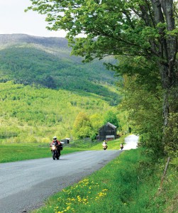
County roads wind past stately old homes made from the ubiquitous fieldstone that encouraged so many farmers to move west during the 19th century. There are still many working farms in the region, and we are slowed occasionally as barnyard fowl cross the road attempting to propagate their kind.
Afternoon finds us nearing the southern edge of the Adirondacks. I recall the horse-drawn buggies favored by the Amish community that has settled near Stone Arabia, and share that bit of local knowledge with the group. Winding roads and hilly terrain combine to create short sight distances, and even at legal speeds the operators of motor vehicles come up quickly on the buggies, sometimes with tragic consequences. “Road apples” left by the horses are an ever-present hazard, too.
Farther north, Carl points us to another asphalt gem from his knowledge bank: Tracey Road (CR6), a practically perfect eight miles of asphalt that slice through Essex County forest. Why can’t this road continue another hundred miles?
The route east entails crossing Lake Champlain. There are several ways to get to the other side, but only two include roads. We choose the southern option, the Champlain Bridge connecting Crown Point, New York, and Chimney Point, Vermont. Historic sites on both shores preserve centuries-old forts and settlements.
On the Vermont side, flat farmlands along the lakeshore end abruptly as the Green Mountains reach skyward. Alongside those mountains we find Brandon Motor Lodge, a clean, friendly and cost-effective lodging just outside of town. Over pizza and beer, we take advantage of Brian’s mobile Internet to gain some local knowledge about the weather. Holy change of plans, Batman! The same storm system that ploughed through the East yesterday has reformed off the coast and is on a collision course with our plans for tomorrow. Four to 8 inches of rain are forecast, accompanied by high winds and flash flooding.
My riding buddies know my theory about rain and riding: “There’s no bad weather, just bad gear.” But that much rain, especially in the mountains, could be life threatening on two wheels. Reluctantly we conclude that our ride is done. We all head home in the morning, agreeing over breakfast to resume the ride later.
In three months, later arrives. My group hooks up after work near White River Junction, Vermont, and heads northeast toward Waterville Valley, New Hampshire, for the night. Route 49, our road into the Valley, is a serpentine stretch sandwiched between some of the Northeast’s best alpine ski terrain. Oh, for a closed road and a liter-class sportbike!
Fortunately, Bob (who is putting us up for the night) shares his local knowledge: Police from both towns the road cuts through know that speeding is hard to resist. Keeping the pace reasonable, we enjoy the road without meeting the local constables-on-patrol.
We’re in the heart of New Hampshire’s White Mountains, which is Greg’s backyard. In the morning he points us to Lincoln and the Kancamagus Highway, a curvaceous two-lane flanked by world-class mountain scenery. This road makes every “must ride” list in the Northeast, but some local knowledge improves the ride. A left on Passaconaway Road, a winding ribbon through dense forest, bypasses the tourist traffic in North Conway.
Conveniently delivered to Route 16, we head north to ride the Mount Washington Auto Road. It’s steep, narrow and only partially paved. There are no guardrails. A sign at the entrance states bluntly, “If you have a fear of heights, you may not appreciate this driving experience.” We pay our admission fee and begin our ascent.
The sun is obscured at the base, but the ride up is invigorating as the temperature drops and the view expands as we emerge from the clouds. The summit is the highest point in New England (6,288 feet) and where the highest wind ever observed by man (231 mph) was recorded on April 12, 1934. We arrive at the top just as the famous Mount Washington Cog Railway steams in carrying passengers who opted to let someone else drive them to the top. On our ride back down, it’s nearly five miles before I shift out of first gear.
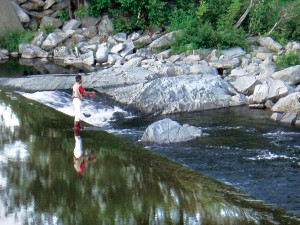
At the base of the mountain we set course for Maine. Al’s the native in these parts, and along scenic Route 17 he suggests an up-close look at Coos Canyon. There’s a scenic lay-by with easy access to the river. It’s a hot day and the river makes a fine swimming hole. Farther along we stop for a panoramic view of Lake Mooselookmeguntic and the wilderness of western Maine.
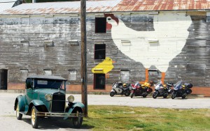
About midday, a mural of a chicken three stories tall seems to be saying, “Take a break and chat with a farmer.” Sheridan Thornton explains that he and his brother Charles have been poultry farmers since 1959, the past five years organic. Here in Rumford, Maine, they run a nursery for chickens, raising 30,000 birds from eggs to 21 weeks when they’re trucked to a laying house. There they produce the raw material for our sunny-sides and Benedicts. Sheridan shows us his 1931 Model A Ford. “Took it for a ride just the other night,” he explains matter-of-factly. “Still runs well.”
Sheridan suggests we grab a bite at the Route 2 Diner up the road in Rumford Center. The special of the day is a blue-cheese bacon cheeseburger. The whole group opts for this creation, and we sing the praises of local knowledge.
Afternoon finds us in the Carrabassett Valley, known to skiers and snowboarders as home of Sugarloaf. In summer, the valley has many options for camping in tents and rustic cabins. Al leads us to the Seven Falls Cabins in the tiny village of New Portland, not far from where he grew up. The temperature plummets after dark so the warmth of a campfire is welcome, and motorcyclists gather with fly fishermen for conversation and libation. On this vividly clear August evening, the Milky Way glows like a river overhead.
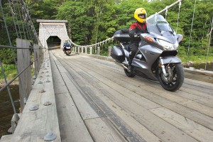
In the morning, Al’s local knowledge gives us our first mission: ride across the Wire Bridge, which spans the Carrabassett River just downstream of camp. Built in 1812, it is one of the last surviving suspension bridges from that era. Two centuries later it’s still an impressive feat of engineering. Mission two is a short ride to photograph the street sign for Katie’s Crotch Road. The sign’s been stolen; Al says this happens predictably whenever the highway department replaces it.
Heading north on Route 16 we happen upon Bailey Farm Windmill in North Anson, providing an opportunity to chat with more farmers. Myron and Faye Seavey, who own the farm but not the windmill, tell us that people stop by regularly to take pictures and say hello. Built in 1905 to pump water for a farm, the octagonal windmill is listed on the National Register of Historic Places and is currently in the care of a local historical society. The balcony, added during World War II, provided an observation point where locals watched for enemy aircraft.
Stomachs begin signaling that our morning feeding is overdue, so we order breakfast at the Kingfield Woodsman. With Maine blueberries in season, pancakes are a good selection. Also having breakfast are two busy-looking dads, with five young girls between them. A friendly inquiry confirms that the moms are spending a quiet Sunday morning without kid duty.
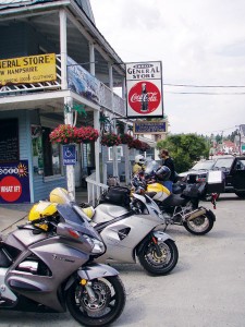
We retrace some of yesterday’s best curves on Route 16, then cross back into New Hampshire. In Errol we rest at the General Store where a smiling old lady comments on our helmets, all of which are yellow. “Goodness, one can’t miss seeing you boys!” Yes, ma’am, that’s the idea.
To the south, Route 26 dips back into Maine and through Grafton Notch State Park. The beautiful stretch of wilderness is ripe with waterfalls and hiking trails, but the road through the notch curves so nicely we keep riding. By Fryeburg, our individual destinations begin pointing us toward several states. We top off our tanks, say so long, and head for home.
It’ll take longer, but I opt for the backroads home and the chance to pick up a bit of local knowledge along the way.
[From the August 2008 issue of Rider]


