story and photography by Philip Buonpastore
The sunlight slants in on its autumn angle, backlighting a never-ending parade of yellow-, orange- and red-leafed maples, oaks, poplars and elms as I ride one of a hundred twisting roads in North Georgia. Around every turn is another brilliant scene of electrified color—even the double-yellow lines and orange diamond-shaped road signs blend with nature’s massive color scheme. It is the last weekend in October, and this is a particularly good year for the fall colors. Long shadows spill across the road like a river overrunning its banks, and the sun is never in my eyes, but over my left shoulder. I find myself having to pull my attention away from the scenery and back to the road, as these mountain roads are not to be taken for granted.
In Georgia’s autumn, the seasonal tug-of-war between cold fronts and Gulf of Mexico warming trends can vary daily temperatures by more than 20 degrees until winter takes hold, allowing 70-plus-degree days well into November. At 72 degrees it is just such a day, creating a combination of excellent roads, ideal riding conditions and spectacular jaw-dropping scenery.
To anyone who rides a motorcycle in the Southeastern United States, the roads of North Georgia into Southern Tennessee and North Carolina are well known and frequently ridden. Much of the three-state area is contained within national forests, protected and pristine, and any weekend day will find riders taking in the curves and scenery in three seasons, with an occasional temperate winter’s day thrown in for good measure. With the autumn colors in full swing, I have set a task of riding and cataloging several different routes over a three-day period.
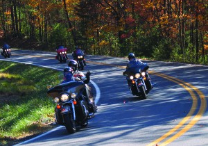
Day one begins riding west on State Route 52 from Highway 365, 50 miles north of Atlanta. State Route 52 is a fine riding road in its own right, with curves that go from predominantly gentle to moderately challenging and work as a rider’s “warm up” going westward toward Dahlonega. The tourist-oriented town is known for its gold-mining history and museum of same, and a town square offering several worthwhile restaurants and bistros. A few well-known hotel chains are also located here, and the town works well as a “base of operations,” allowing you to launch into excellent day rides north, east or west and still be back by dinnertime.
Out of Dahlonega, Highway 19 north leads to State Route 60 toward Suches. Any adjectives used to describe this road fail to adequately capture the experience. Scenery that is gorgeous any time of year becomes exceptional when steeped in autumn’s colors. The two-lane road is well paved and maintained and the ride exhilarating, but caution is necessary as it is a ribbon of tight “S” curves and diminishing-radius turns over its entire length. With an alert and confident rider, however, this road can return some of the best riding experiences you are likely to have on a motorcycle. Scenic vistas sight to the horizon, with spec- tacular views of the Blue Ridge Mountains regardless of season. At approximately 5 miles up, a look to the left into the area known as Woody Gap will reveal a great expanse of multicolored forest, with Springer Mountain rising in the distance. Other stops feature information on area Civil War battles, Native American history, gold-mining sites and hiking trails.
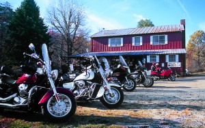
Seven miles of twisting road leads to the town of Suches, home of the now famous T.W.O. or Two Wheels Only, a lodge that caters to motorcycle riders and travelers (www.twowheelsonly.com). It is a quaint wood and log structure with dining facilities, couches and easy chairs, a TV running motorcycling videos and walls covered with rider memorabilia. The lodge features great food, a regulation-sized pool table and coffee by the cup on the honor system. Weekends during “the season” you will find local riders as well as long-distance travelers there, armored-suited sportbike riders and Harley riders in leathers, and the gravel parking lot filled with bikes of all styles and vintage. It’s a great place to take a break, talk bikes, and get information on area roads.
The “Georgia Triangle” is a well-known riding circuit in this area. As the name implies, the triangle consists of three roads—State Route 60 to State Route 180, then back to Highway 19, which heads south to the origin point for a 37-mile round trip. State Route 180 begins at a right turn about 100 yards north of T.W.O., and this segment is without a doubt the most challenging portion of the triangle. It is a truly mind-boggling road and one you don’t want to miss, but take it at a deliberately leisurely pace the first time through. The road begins as sedate two-lane blacktop leading to Lake Winfield Scott, a small scenic lake that acts as a large reflecting pool for the foothill mountains that surround it. Once past the lake, however, it’s off to a roller coaster of a ride.
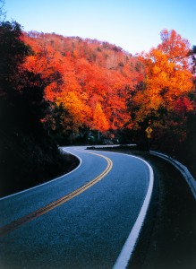
The first indicator of what’s ahead is a sign that reads “Sharp Curves and Grades Next 5 Miles,” a monument to understatement. State Route 180 snakes through the Sosbee Cove Scenic Area with 10-mph speed limit signs on some curves and nary a straight-line section to be had. Here the road looks more like a hiker’s switchback trail than one intended for traffic, and it is known for having more sharp curves and steeper grades than any other paved road in Georgia. Vigilance is ever necessary—while State Route 180 is a pure adrenaline rush on two wheels, it also claims the largest number of motorcycle accidents in the area.
At the end of State Route 180, the road tees into Highway 19, and here you will find Vogel State Park, a moderately sized mountain park featuring Lake Trahlyta, deep blue and surrounded by trees at peak color. Lodging is available here, with everything from basic tent camping to small rustic log cabins, three-bedroom cottages and motorhome sites, even a general store. Make reservations, as peak season runs from late April through the Thanksgiving holiday, and autumn is particularly popular (Poplar!).
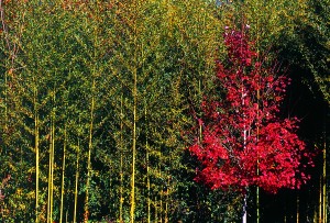
Highway 19 south is the last leg of the triangle. Being a state highway, it is wider with intermittent passing zones throughout, but like most of the roads in North Georgia, it is a continuous series of S curves all the way down the mountain. While it might be considered the safest road of the three, take nothing for granted—it can be a handlebar full as well.
With autumn’s abbreviated day and periodic stops for photographs, the sun is low in the sky when I start the ride home. Sunday promises mid-60s temperatures and clear for the ride on day two.
The next morning I arrive back in Dahlonega, this time to head farther west on Highway 52 to begin a long 175-mile loop through southern North Carolina. The ride will take four to five hours with stops for fuel, food and photographs. Highway 52 begins as a sedate and gently curving highway toward Ellijay, allowing a relaxed (but alert!) frame of mind. The road borders the southern end of the Chattahoochee National Forest, passing Amicalola State Park on the way, with the autumn show in full swing for the entire 39-mile ride up to Ellijay.
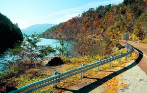
Once through Ellijay’s town square, State Route 52 begins an ascent up to Fort Mountain Park. While it’s a lesser-known road in North Georgia, it is easily one of the most enjoyable, full of challenging twisties and scenic stopping points. A few miles past Ellijay, the road makes a right turn directly into the national forest. Here, as the road ascends, the sun shines through autumn foliage, bathing the entire 25-mile length of highway in a bright golden glow. Once again, adjectives cannot capture the truly magical feel of the surroundings—it is something that must be seen to be fully appreciated.
Once past Fort Mountain Park, the road descends 7 miles off the mountain into the little town of Chatsworth. It is a good place to take a break, as once out of the area options become more scarce. Taking U.S. Route 411—a camel-backed highway that heads due north for 25 miles—allows some decompression time after the rock ’n’ roll of State Route 52. The highway crosses the Tennessee state line to meet Scenic Highway 64/74 going east toward the Ocoee River Gorge. Here the tan-colored highway, now called “Old Copper Road,” contributes to the overall autumn color scheme while it meanders along the cobalt-colored Lake Ocoee and River, famous for whitewater rafting and kayaking. The highway allows relaxed viewing of the scenery, with easy winding curves throughout. Be aware of vehicles with pedestrians loading and unloading kayaks around any turn though, as well as the occasional slow-moving RV.
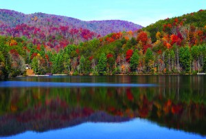
At about the 27th mile, Highway 68 goes south through Grassy Creek and back over the Georgia state line at McCaysville. Taking State Route 60 here leads back toward Suches. Like farther south, the road is an exhilarating series of tight turns and S curves for most of its 46 miles, with only a few straight-line sections allowing you to catch your breath.
This loop is a long ride, and some may be ready to call it a day before completing the entire 175 miles. Most towns along the route are of reasonable size, and provided you call ahead you can usually find lodging.
The third riding day takes me a few miles farther east to the town of Helen, Georgia, with its alpine-styled chalets, German restaurants and general Bavarian theme. North Georgia’s best roads are often within earshot of towns featuring a full complement of hotels, house and cabin rentals, restaurants and tourist attractions. Several of the establishments in Helen cater to riders, and weekend afternoons will find rows of motorcycles parked in front of restaurants and watering holes all along State Route 75, the main drag through town.
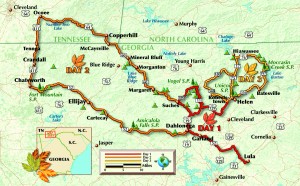
But if you’ve come to ride, you’ve come to the right place (here, there are no wrong ones!). There are both excellent riding roads leading into and out of the area and several fine circuit routes around Helen. My ride for the day begins on the west side of town going north on GA 356 past the entrance of Unicoi State Park, leading to GA 197. The route is true-to-form with moderately twisting roads and gorgeous scenery, lakes reflecting autumn colors, and temps in the comfortable 70s. A rider’s dream. Once again, you’re riding through the Chattahoochee National Forest and traffic is usually light, with as many motorcyclists as automobiles on these roads. Going west on Highway 76 for 15 miles leads to GA 75 south returning to Helen, and both roads are highly recommended —Highway 76 for its pine forest scenery and sedate curves, and GA 75 for its extreme ones. It is an excellent loop ride any time of year, made far more enjoyable by the colors of the season.
At the outskirts of Helen, a right turn on Alternate GA 75 and proceeding several miles south will bring you to GA 348, the Richard B. Russell Scenic Highway, another road not to be missed. This 14-mile highway runs near the top of the Appalachian chain here, offering fantastic views from some of the highest elevations in the area. GA 348 connects back to State Route 180 and the Georgia Triangle area, crossing the Appalachian Trail on its way up to Maine in the process.
Even a brief glance at a Georgia map will show many roads and areas not covered here. Three days of riding allows neither the time nor scope to cover many of the best roads in the area. There are plenty left to try packed into a wedge north of Lake Lanier and loosely bordered by Interstate 75 northwest and Interstate 985 northeast out of Atlanta, where any road promises an excellent return on the investment any time of year. Autumn adds the annual miracle of the changing fall colors, and you should make plans to see it on two wheels—it’s something you’ll never forget.
[From the April 2007 issue of Rider]


