
Let’s be honest. The reason many motorcyclists are drawn to the old gold-mining town of Oatman located on historic U.S. Route 66 in Western Arizona, besides the authentic Western atmosphere and wonderful Arizona motorcycle roads, is the saloons and the absence of a helmet law. Not the smartest of combinations, considering around the next bend heading into or out of town could be a wandering burro impeding your progress. And these stubborn creatures don’t move. The famed wild burros hereabouts—descendants of those released by 19th-century prospectors and gold miners—have free rein and are granted legal right-of-way. No one to sue or blame but yourself.

Many riders hang out at the Oatman Hotel and Restaurant, where Clark Gable and Carole Lombard spent their wedding night back in 1939. The hotel is still capitalizing on the renown by offering the amorous two-up touring couple an indulgent stay in the same honeymoon suite. Amuse yourself while dining here counting the bills wallpapering the premises.

A quartet of German couples on Harleys rented out of Chicago struck up a conversation. Each male wore a Route 66 skull cap, souvenir affirmation that they had followed the Mother Road all this way, so far. I told them about my Edelweiss tour of a few seasons back, and received animated acknowledgment. Munich, Oktoberfest. “Ja!” Dolomites. “Ja, ja!” Neuschwanstein. “Ja! Ja! Ja!” Passo del Stelvio. “Ja! Ja! Ja! Ja!” Cortina. “Ja! Ja! Ja! Ja! Ja!” Grossglockner. “Wunderbar!” Ah, the universal language of touring motorcyclists!

Another interesting stop here is the Back Road Byway of Route 66, out of town over Sitgreaves Pass at 3,556 feet, for 25 miles to Kingman. The only other parallel to this road that I can draw is the notorious Deal’s Gap in North Carolina. The Dragon, though, doesn’t include the precipitous drop-offs should your gaze wander, or the squiggly tar snakes, desert sand, falling rocks, nor as many first-gear turns made treacherous with deep grooves harrowed by vehicle undercarriages.
Route 66 straightens out some as it glides between rail lines of the Burlington Northern Santa Fe Railroad entering Kingman. Old Trail Road follows alongside until landing you in front of the Mohave Museum of History and Arts. Inside this archive of Arizona heritage you learn all about hometown boy Andy Devine, and if you don’t know who he is, then you don’t recall your Western TV and movie history.
Just a block east on what is now Andy Devine Street is the granite facade Powerhouse, built in 1907, but now housing the Route 66 Museum. Continue another block east and you will behold the visage of Willie G. astride a V-Rod parked in front of a mural motif of Harley history decorating the four brick walls of what used to be the local Harley shop decades ago. Willie G. is only a full-size cutout done up for a downtown revitalization project by the same artists who decorated the inside of the current Harley shop, Mother Road Harley-Davidson at 2501 Beverly Avenue. Other brands are sold as well.

The White Cliffs and Locomotive Park are two other areas worth a look while in town. The downtown area offers a walking-tour delight, with more than 60 buildings on the National Registry of Historic Buildings. The Arizona Inn at 411 West Beal Street is a comfortable, relatively inexpensive place to stay, and adjacent is an excellent diner popular for breakfast. Authentic Route 66 cuisine is served at Mr. D’z—just another stretch east along the famed route.

Follow Interstate 40 east of Kingman for 20 miles and turn south onto U.S. 93, which enters a sagebrush-studded basin following the Big Sandy River. Out of Wikieup the road rises and widens to two lanes, becoming the Joshua Forest Parkway of Arizona Scenic Road. Besides the aforementioned joshua trees, saguaro cacti make their appearance, jutting from rocky outcroppings of Superstition Mountain terrain.
The road spans a chasm over inappropriately named Burro Creek, because I figure it would take a river to carve out this fissure. Past Burro Creek balanced rocks stand about like sculptures about to topple. Just past a lone trading post aptly named Nothing, the view becomes expansive of distant layered mountain ranges.

Pick up County Road 97 to Bagdad. Enjoy the next 12 miles of dips and weaves. No racing speeds here, as you could find yourself airborne; besides, there are too many blind rises. At the junction of County Road 96, turn left and ride the four miles to Bagdad over a beautifully surfaced, high-speed, curving slice of macadam.
The road dead-ends at this tiny copper-mining town resting at an elevation of 4,000 feet. Despite its isolation, this spot is a meeting ground for sporting riders because of the 75 curvaceous, lonely miles between Prescott, U.S. 93 and here. The Miner’s Diner also draws the ravenous, because you can expect fulfilling victuals in a mining town, and this establishment doesn’t disappoint. Tours of the mine are also available, by appointment only: (928) 633-3490.
Backtrack now for 22 joyous miles into Hillsdale, and revel in the uphill constant-radius horseshoe bends. Turn off the main road into Hillsdale and visit the country store. A pleasant grandmotherly lady will regale you, while the six alcoves of boutique offerings entrance. I guarantee you won’t leave without purchasing an artifact. You’ll have to turn around here, lest you wish to navigate 20 miles of dirt road to U.S. 89.
The road out of Hillsdale becomes County Road 15 for 18 gently swaying miles through cattle country into Kirkland. Here is a café where riders also like to congregate. Proceed straight and you will end up on U.S. 89 in a few miles, a delightful mountain road into Prescott, but often clotted with RVing tourists and retirees. So turn left instead onto County Road 10 to Skull Valley, another pleasant hamlet nestled in a mountain foothill basin lush with cottonwood and willow. County Road 10 out of Skull Valley is heavy with tar snakes, but the highway climbs and climbs with gentle sweepers up to 6,000 feet into a pine forest. Before you know it, the road discharges you the back way into Prescott.
Prescott’s downtown square is rife with history. The Earp brothers used to patronize the saloons along Whiskey Row. Doc Holliday won and lost a fortune here, so the legend goes. The most famous surviving watering hole of the era is the Palace Hotel and Bar, made even more renowned when part of the rodeo movie Junior Bonner with legendary motorcyclist Steve McQueen was filmed here. Motorcyclists converge at Courthouse Square to absorb the Western aura and hang out at the Harley boutique.
We’ll ride the uninspired 50 miles of U.S. 89 between Prescott and Ash Fork with a couple of loops along old 89 just to keep it interesting. We meet up with Route 66 again at Ash Fork, and this section of the Mother Road from here to Topok along the Colorado River is the longest continuous length of Old 66 left in the country. It’s a marvelously lonely stretch of highway through the lush Arizona high country awash with the lavender plumes of Indian paintbrush swaying rhythmically under the perpetual breezes.
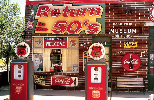
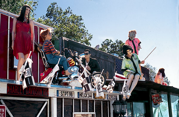
You’ll find plenty of kitsch along Route 66, and if that’s your druthers, go for it. I’m here for the ride. In Seligman, however, the souvenir palace under the canopy with a ’50s mannequin diorama will serve all your trinket needs; and wouldn’t you know, there happens to be another Harley boutique attached. The Grand Canyon Caverns, another 20 miles or so farther, may interest the spelunkers, since they’re claimed to be the largest dry caverns in the United States, 21 stories below ground. You’ll even get to see a mummified bobcat.
For a genuine encounter in these environs, stop at the Frontier Lounge in Truxton. This is the heart of the Hualapai Indian Nation, and you’ll often find many tribesman meeting here for a powwow over a few cold ones. A few years ago, I had a conversation with one of the local Native Americans and learned that the Tribal Council voted against a casino in the area because the tribe has reverence for the land and doesn’t wish to desecrate it. The Hualapai operate a lodge and restaurant in Peach Springs, so be sure to support them on your ride through.
Outside of Truxton you’ll run across the first Burma Shave signs, a lingering bit of Americana: Train approaching/whistle squealing/Pause! /Avoid that/rundown feeling/Burma Shave! There are others, but revealing them would spoil the fun of discovery. The stone buildings at Hackberry preserve another vestige of the bygone era.
When Route 66 enters Kingman, turn east on I-40 a few miles to the DW Ranch Road exit. Head south on County Road 259 and you will be rewarded with a high viewpoint run into Hualapai Mountain Park (the Indian word Hualapai means pine tree). At the T-intersection past the fire station, turn right for the downward glide into Kingman and a rejoining with Route 66.
For those up for the challenge, all that remains is to take the anxiety-provoking stretch of Route 66 back to Oatman to conclude the roughly 350-mile round trip. Now it’s only 25 miles to Needles or 30 miles to Laughlin. Just watch out for the burros.


