story and photography by Sean Coker
[Oregon Motorcycle Rides: Hells Canyon and Beyond was originally published in the July 2010 issue of Rider]
We begin our Oregon motorcycle ride in the heart of Nez Perce territory, in Union, Oregon. Young Chief Joseph fought for justice only to fall short in his fight to freedom. Defying a United States mandate to move onto a Kansas reservation, Joseph and 800 Nez Perce eluded General Howard for 1,500 miles as they rode toward Canada, only to be captured at Bear Paw Mountain, 40 miles shy of the border and safety.
We leave Union south on Main Street/Highway 203 and steer east toward Medical Springs, tracing along the banks of Catherine Creek. Thirty-mph turns heave and fall alongside Ponderosa pines and a myriad of magpies. Past Medical Springs and just before Highway 203 reaches Interstate 84, we carve southbound on West Airport Road/Lindley Road, paralleling caravans of semis speeding across the Beaver State. After four miles of scenic super slab, we merge onto Highway 86 east toward Richland.
A graveyard of old tractors, plows and combines oxidize in a field adjacent the National Historic Oregon Trail Interpretive Center ($5), a museum focusing on how mining, settlement, geology and Native Americans helped shape eastern Oregon’s landscape.
Traffic is nonexistent as sweepers cut alongside the Powder River toward the Snake River. Passing near the town of Halfway, located one mile off of Highway 86, we stop for gas, which is not available for 70 miles.

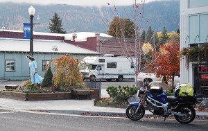
At Annie’s Café in Richland in search of a home-cooked breakfast, we parked alongside a Yamaha FJR. Inside we find Steve Folkestad, founder of the Hells Canyon Motorcycle Rally, who is scouting loops for the June 12-16, 2009 rally in Baker City. When asked for recommended rides he points to a map and says, “Devil’s Tail.” After breakfast we heed his advice and head toward Hells Canyon.
Situated halfway between the gold mines of Cornucopia and the town of Pine Creek, Halfway gained notoriety in 2000 when the town was renamed Half.com, becoming America’s first website town. We head back to Highway 86 and continue east. Past Cooperfield we cross the Snake River, near Oxbow Dam, entering Idaho and head north onto Devil’s Tail Road, aka Hells Canyon Dam Road.
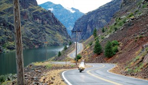
The Devil’s Tail Road was affectionately named in 2008 by the thousands of riders who attended the rally on the second Friday in June. The mighty Snake River appears docile as it suns on the valley floor of the deepest gorge in the United States. Power lines hang like tinsel on steep hillsides and scorched earth nurtures only rocks and small weeds. The 22-mile road yields long sweepers and tight switchbacks trespassing along the roads edge and we pass a sign that warns “Private road. Travel at your own risk.”
Migrating back into Oregon, we head west toward Cooperfield until reaching the junction of Highway 39 and head north to Joseph. Forest Service signage cautions: “FS39 is not maintained during the months of October-April.”

We ride atop the banks of North Pine Creek through a rain of golden tamarack needle. Up and up we climb without a guardrail to block the view or act as a glove if we fall, following signage to Hells Canyon Overlook via Hells Canyon Rim Road/3965. Thirty turns and three miles later we deploy our kickstands and walk toward the abyss.
Staring at the snowcapped Seven Devils Mountains across the gorge, Hells Canyon has evoked different feelings from the many people who have passed through its basalt cliffs. Native Americans depended on the canyon’s evergreen plant and wildlife to sustain themselves during harsh winter months. Settlers considered the chasm a hindrance requiring circumventing. Modern man sees the canyon as a place to recreate, ride or hunt big horn sheep. While attitudes about the canyon have varied, the canyon has changed little over hundreds of years. The sagebrush still grows, the Snake still flows and peregrine falcons still crowd the rim rock.
Rain clouds pooling overhead pry us from an intoxicating view and we follow FS 3965 back toward Highway 39 north toward Joseph. At the north edge of Wallowa Lake, against the backdrop of the snowcapped Wallowa Mountains, is the unassuming resting place of Joseph’s father Old Chief Joseph.

Even in death the Josephs are still haunted by the U.S. military as Mount Howard, named after the Nez Perce rival General Howard, overshadows and looks down on the Nez Perce leader’s final resting place. His gravesite is adorned with gifts of coins, cigarettes, broken watches, bullets, candy and a dream catcher that twirls in a cool breeze.
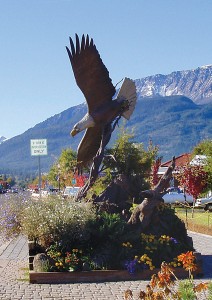
We continue west, entering the town of Joseph. Adorning every intersection on Main Street is a bronze statue cast by a local foundry. Gas is available in town, though is more prominent as we continue northbound on Highway 82. We follow along the banks of the Wallowa River as it threads past horses in Enterprise and sheep in Minam.
Tall cliffs block out sunlight as we near the 4,000-foot pass, allowing snow to accumulate on the road’s edge. We pass grain fields in Elgin, the “grass seed capital of the world,” and Imbler before turning eastbound on Highway 237 toward Cove and follow it until arriving in Union and heading southbound on Main Street back to Union.
“We could have escaped from Bear Paw Mountain if we had left our wounded, old women and children behind,” Joseph explained. “We were unwilling to do this.” Joseph was captured and never allowed to resettle Wallowa County. He died in 1904 and was buried in the Colville Reservation—250 miles away from his home.
Resources
Annie’s Café
209 Main Street
Richland, Oregon 97870
(541) 893-6167
Hells Canyon Motorcycle Rally
www.hellscanyonrally.com
National Historic Oregon
Trail Interpretive Center
22267 Highway 86 Flagstaff Hill
Baker City, Oregon 97814
(541) 523-1843
Union Hotel
326 N. Main Street
Union, Oregon 97883
(541) 562-6135
www.theunionhotel.com


