Story and Photography by Scott Webster
[A Motorcycle Ride through Old Arizona first appeared in the January 2010 issue of Rider magazine]
At a party long ago, King Herod offered the fetching young Salome up to half of his kingdom as a reward for her fancy dancing. Clearly, he’d had a few drinks.
Lately, millions of us have blown half our kingdoms stone sober, doggedly obedient to the buy-and-hold strategy favored by our dim-bulb investment advisors. Herod at least got some entertainment.
These were my reflections aboard a 2009 Harley Fat Bob rented from Chester’s Harley-Davidson in Mesa, Arizona. Months earlier, with nest egg more intact, I’d booked a five-day Arizona Motorcycle ride as relief from a bleak western-Washington winter.
“Go ahead,” encouraged Rosalie. “Our retirement’s toast already. We’ll both be looking for jobs when you get back.” Could I really get my old job back, or do convicts now break all the rocks?
Vulture Mine Road out of Wickenburg began to weave like Salome and snapped me back to business at hand. Forty miles of lonely, new pavement flowing in beautiful, hilly curves proposed an alluring dance, indeed. I stopped at Vulture Mine, once Arizona’s richest gold producer. Its collapsed buildings and mine hoists were stark reminders that, like an unwelcome tailgater, bust relentlessly follows boom. I pushed on. I wanted to make Ajo for the night and was behind schedule.

The sun was half-sunk and the sky glowed red as I entered the empty desert of the Barry Goldwater Air Force Range south of Gila Bend. Ajo’s lights looked pretty good as they emerged from the darkness ahead. I wolfed a Dairy Queen burger, checked into my previously reserved, 50-buck cabin, took note of the Dow’s continued descent and fell asleep.
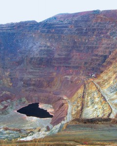
Yet my mood was bright the next morning, feeling the trip properly underway. I paused at a gigantic hole in the ground, Arizona’s first copper mine. Its ore, replaced now with an inverted mountain of air, had fueled Ajo’s prosperity for a long time. That was a while ago based on appearances. I rode east into a rising sun that made diamonds of the broken glass that lines Highway 86, two sparkling ribbons that stretch over 80 miles. I could smell the desert warming with the sun. The Harley loped along comfortably, its “Relax, put your feet up” riding position well suited to sightseeing at 60 mph. The landscape seemed empty and huge. Its stark beauty, and my pleasurable sense of gliding smoothly through it, displaced any worries.
Traveling through the Tohono O’odham Nation I encountered vehicles only infrequently, and those mostly U.S. Border Patrol. At the tribal capital of Sells, I got gas and shared part of my breakfast with a half-starved yellow dog that staked out the place.
An exhilarating side trip up 12 miles of steep switchbacks brought me to Kitt Peak National Observatory. At 6,800 feet it was noticeably cooler as I parked the bike to take a look around. I found my eyes glowing “white-hot” and my wind-exposed chin “black-cold” in an infrared imaging display in the visitors’ center. I was guided through the world’s largest solar telescope, a sort of sun-mining operation with a shaft slanting parallel to the earth’s axis. I showed myself through three other observatories. Despite newer telescopes in orbit and Tucson’s encroaching light, Kitt Peak still does amazing work. Today we explore the universe from a distance—someday we’ll be riding Harleys out there.
A jackrabbit dashed across Arivaca Road…then a coyote. In the wilderness around Arivaca, nature’s contests were on display. Jackrabbits were trying to dodge coyotes; mice to duck red-tailed hawks; cattle to delay their trip to some burger joint. On Arizona’s extensive open range, however, the tables can turn. I adjusted my line for cows several times, and rather more often for cowpies.

I arrived in Tubac in early afternoon. Here, a small Spanish fort built in 1752 became the oldest European settlement in Arizona. Its story and artifacts are preserved in Tubac’s historical museum. I sampled several of the town’s three-dozen art galleries, one of its many good restaurants and splurged with a bed at the very nice Tubac Country Inn.
I burbled through early rising tourists to start day three, taking a northern route that included some beautiful hills on Highway 83 south of Tucson. At Sonoita, the heart of Arizona’s emerging wine industry, I turned east toward my short day’s destination, the silver-stoked boomtown of Tombstone.
I’d enjoyed books and movies about Tombstone and planned to take a little time to explore the place. Fifty bucks bought a spacious room with the name “Rose” on its door over the Silver Nugget Saloon in the heart of town. It opened onto a classic western balcony over a classic western street, the ideal spot to bushwhack a bad hombre or, failing that, watch the sunset. Dirt has been trucked in to topcoat historic Allen Street. The Crystal Palace Saloon, Birdcage Theater and other original structures along it date from the 1880s and are remarkably well preserved—the result of the town being essentially shuttered when the nearby silver mines flooded in 1885. These days 45-caliber Colt Peacemakers make the town literally boom again as period-clad actors reenact historic gunfights, including “the big one” at the OK Corral. I bagged the trip’s most vivid memories as I walked Tombstone’s darkened streets bathed in soft moonlight and saloon music, tracing the route that Wyatt & Co. took to disarm some cowboys.

I departed before dawn, intent to cover more ground on day four. I rustled up a good breakfast in historic Bisbee, another boom-then-bust mining town. Leaving Douglas, I embarked on the trip’s loneliest stretch. Arizona 80 is an asphalt ribbon seemingly dropped from the sky. It snakes through the landscape often with no sign, guardrail or power pole for many surreal miles.
This is Geronimo’s country. In 1886, the Apache fighter finally packed it in, more worn down than defeated, surrendering conveniently close to today’s roadside monument. Geronimo would certainly be a motorcycle rider, and I imagined him riding along through his familiar turf. For excitement, we launched a daylight raid on southwest New Mexico then melted into westbound traffic on Interstate 10.
I hoped to ride up Mount Lemmon that day before meeting friends in Tucson for dinner. A few hours of highway intervened, so the Fat Bob’s big road-eaters got to work. Traffic was light, the weather spectacular and the scenery interesting, especially many miles of improbably stacked boulders around Benson.
Mount Lemmon looms over Tucson, 9,800 feet at its peak with a drastically twisty, 26-mile road almost to its top. It was a warm 80 degrees at the bottom as I passed an electric sign flashing: “Icy Conditions Ahead.”

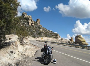
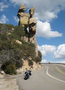
Halfway up, I passed an array of hoodoos; towering, abstract totem poles of sandstone. It’s a safe bet that Tucson doesn’t get very serious earthquakes. I passed a few cars and motorcycles pointed down and a surprising number of bicyclists pointed up. To each of the latter I flashed an admiring salute. Fortunately for them, it was growing steadily cooler…a lot cooler, actually.
I didn’t make the top. Fog began to form inside my visor. Then the road’s surface seemed to darken, not wet exactly, but some distinct change. Gentle traction tests were inconclusive. I pressed upward and the road darkened further. When sparkles began to appear on the pavement (sublimating ice crystals, I suspected), I pulled over near a sign indicating 7,500 feet. With friends and dinner waiting below, and a virtually new rental bike under me, I decided not to press my luck. Mount Lemmon’s summit beckons still.
On my fifth day of perfect weather, I continued up Arizona 77 to Winkleman. Locals had recommended the loop ride around Globe, but when that route was inexplicably closed I turned west on Highway 177. Surging copper prices had reawakened dormant mining operations around the world, and things seemed to be popping around Hayden, Kearny and Superior. I stopped for two ore trains and got smiling waves from the engineers—both good economic indicators. The tailing piles were aqua-capped, strangely beautiful evidence of oxidized trace copper.
Highway 60 out of Superior led through steadily building traffic back to Mesa, where the folks at Chester’s were expecting me. A smooth check-in process and a friendly encounter with the owner, near-celebrity E.B. Chester, concluded my Arizona adventure.
Settled aboard a northbound plane, I reflected on my ride, on economic cycles and on an uncertain future. In his offbeat movie, Stardust Memories, Woody Allen speaks from a strange afterlife filled with wind and red, flowing lava, and says, “I’d trade both my Oscars for another minute…one more second…of life!”
On that basis, in the face of a global bust that has cost many fortunes, my five-day ride through Old Arizona was a great investment.
See all the Arizona Motorcycle Ride Tour Images


