Story and photography by M. Cooper Larson
[Wisconsin’s Best Motorcycle Roads: The Rustic Roads Motorcycle Tour was originally published as a Favorite Ride in the March 2007 issue of Rider magazine]
Most of us don’t need a reason to go riding-especially when the riding involves some of the most beautiful roads in the Midwest. But what if you could ride those same roads and earn a prize for doing so?
Well you can! The Wisconsin Rustic Roads Motorcycle Tour offers participants the chance to ride the most scenic roads in the state. And by documenting their visits, motorcyclists can earn a patch and certificate.
In 1973 Wisconsin created the Rustic Roads System, meant to preserve rural roads of exceptional beauty. A Rustic Road may be dirt, gravel or paved; however, it must be a rural road with outstanding natural features. Currently there are about 103 Rustic Roads. Each is numbered and identified with a unique “Rustic Road” sign at each end.

Now comes the fun part. Wisconsin encourages motorcyclists to ride and enjoy the Rustic Roads of the state. The Rustic Roads Motorcycle Tour was created to encourage and reward riders for doing so. By visiting 10 Rustic Roads you earn a patch. If you visit 25 roads, you earn a certificate. To verify your visit, have your picture taken with your motorcycle in front of the Rustic Roads numbered sign. You do not have to be a Wisconsin resident to participate. Group photos are OK and there is no time limit. Once you have completed your tour, forward your pictures to the state for your patch or certificate. Sound interesting? Follow a group of us as we earn our patch.
The first step is to plan the tour. A good place to start is the Rustic Roads Web site (listed on the next page). The Web site has a map of the state showing the location and number of each road. Click on any road and you are linked to a page with a map and information about the road. If you are Internet challenged, Wisconsin publishes a free Rustic Roads book with the same information. To obtain one, you can contact the Rustic Roads Program at (608) 266-0639. But be aware, the book is not updated as often as the Web site. Some roads may not yet appear in print. You’ll also need a Wisconsin Road Map or Gazetteer to plan your tour.

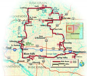
Since we are arriving from Minnesota, we have selected roads near the Minnesota and Wisconsin border. We’ve chosen both gravel and paved roads. If you are a dual-sport enthusiast, you might want to map a tour selecting only dirt roads. Those on touring bikes might want to pick only paved roads.
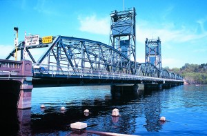
We begin by crossing the St. Croix River at Stillwater, Minnesota, an old river town. The St. Croix River is a National Scenic Riverway; its antique lift bridge is on The National Register of Historic Places.
Our first stop is Rustic Road No. 13. Called Trout Brook Road, it meanders along the Willow River just north of Hudson, Wisconsin. Along the wooded route we see the remains of an abandoned fish hatchery, old fishing cottages and Willow River State Park. After stopping for pictures we head south from Hudson on County Road F, which follows the St. Croix River. We turn east on County Road FF to our second stop.

R.R. No. 92 is called Happy Valley Road. It lies just south of River Falls, Wisconsin, and it’s a winding and hilly route. Trees line both sides of the road. As we ride through a canopy of oaks and maples ablaze with fall color, it feels like we’re riding through a kaleidoscope.
A short distance north is Highway 29. We are headed to Menomonie, Wisconsin, and the beautiful Red Cedar River. Our destination is R.R. No. 89, which runs along the banks and bluffs of the river. About two miles into our ride we encounter The Devils Punch Bowl, a miniature canyon with a small waterfall carved by the last glacier 12,000 years ago.
For our next destination we are going for a two-fer, two Rustic Roads in one stop. Just west of Menomonie we catch County Road Q north to the town of Wilson. Q is one of those rural roads often called “farm-to-market” roads. Twisting, rising and falling, they follow the contours of the land. Farm-to-market roads were laid out long before highway engineers decided roads should be straight and boring.

Our destination is R.R. No. 3 and R.R. No. 4. Both border the Glen Hills Watershed Park. No. 3 is called Jerdheim Road and is paved, but No. 4 is gravel. We take our pictures at the intersection of the two roads. Five roads down, five to go.
Continuing north on Q our next stop is Amery, Wisconsin, and R.R. No. 28. Amery sits on the banks of the Apple River. This road passes Apple River Park and then crosses the river. We park by the bridge to take some pictures and document our visit. The park is filled with people. A young couple has chosen the banks of the river for their wedding.
From here we catch Highway 8 to the town of Turtle Lake, Wisconsin, and The Turtle Lake Casino. We stop to try our luck at winning a Harley. Wiser but poorer, we leave for R.R. No. 67 and we follow it as it meanders through forests, past Lake Skinaway, through wetlands and over Beaver Brook.
Instead of staying on the road when it turns east, we continue straight to County Road G and follow it to our favorite named road: Hunkey Dorey Road. Hunkey Dorey Road goes past the 1902 Hunkey Dorey Resort and intersects with R.R. No. 41, called Clara Lake Road. We pause to take our pictures and admire the wooded surroundings.
Just north of R.R. No. 41 we catch Highway 48 west to Luck, Wisconsin, and R.R. No. 93, also called the Chippewa Trail. Legend is that the Chippewa Indians used this route as they traveled between encampments. It’s a lovely gravel road that travels past ponds and wetlands.
We’ve almost completed our journey. Our last stop is R.R. No. 101 just outside of St. Croix Falls, Wisconsin. We started our quest at the southern end of the beautiful St. Croix River. Our final road is toward the northern end of it. We pause to take more pictures, then head south to Stillwater, Minnesota, our starting point.
We’ve done it: earned our patch. All that is left is to develop our pictures and send them in for confirmation. In a few weeks our patches will arrive.
Like to earn your patch? Contact the Wisconsin Department of Transportation Motorcycle Safety Program, P.O. Box 7936, Madison, Wisconsin 53707-7936; (800) 368-9677; www.dot.wisconsin.gov/travel/scenic/rustic roads.htm


Checking this out tomorrow!! Hope its as amazing as you say 😉
Andrew…how was your trip?