Although I live in Sweet Home Alabama, my home state is not known for such sweet motorcycling roads, if a sweet road is defined as a curvy one. One of the few exceptions is a route around Little River Canyon in the Little River Canyon National Preserve near Fort Payne, Alabama.
The ride experience is a little bit like Colorado in reverse. Instead of high rocky mountains towering above, this ride blesses the rider with deep rocky canyons below. Throw in a river, a twisty road, some waterfalls, a sunny day and your favorite motorcycle, and you might call the ride sweet, too.
The Little River winds its way from headwaters in Georgia across Lookout Mountain before emptying into Weiss Lake in Leesburg, Alabama. It’s one of the southeast’s deepest canyons and carries the nation’s longest mountaintop river, running nearly its entire length down the middle of Lookout Mountain in northeast Alabama. It is also among the cleanest and wildest waterways in the South because there are no dams to regulate its flow, and few manmade developments to cause pollution. Desoto State Park is also included within the preserve’s 14,000 acres, but that’s another story. Little River Canyon National Preserve also offers the daring adventurer rock climbing, kayaking, hiking and fishing. Just be careful and make sure someone knows where you are going and what you intend to do. The preserve is a mostly primitive area and is not exactly crawling with folks who can come to your rescue if there is trouble.

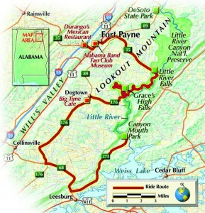
It’s advisable to stop by the park headquarters at 2141 Gault Avenue in Fort Payne, Alabama, before your ride begins. There you will find maps of the area and various information about the preserve. The park headquarters phone number is (256) 845-9605. It’s easy to access this ride route off Alabama Highway Interstate 59 at exit number 218, where you will find a number of motels and restaurants. If it’s anywhere near lunch time, you should stop at Durango’s Mexican Restaurant, about one Evel Knievel jump east of I-59 (Exit 218), on Route 35 on the right. They serve up a good “Speedy Gonzales” dish.
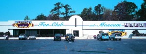
Heading east off I-59 on Route 35, continue past Durango’s and you will see the Alabama Band Fan Club and Museum on the left. It’s a large building that is divided into a museum and gift shop. Inside there are a number of personal items from the band members, so it’s worth a stop. The museum’s phone number is (256) 845-1646, and it’s open Wednesday-Saturday from 8 a.m. to 5 p.m. and Sundays noon to 5 p.m. The museum section closes at 4:30 p.m. each day.

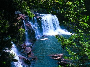
Back on Route 35 southeast just past the 176 junction, turn right into the Little River Falls parking lot. There are restrooms here (outhouses, no running water) and a 50-car parking lot with picnic tables and grills close by. It’s a short hike down to the waterfall area and there are hiking trails up and down the crest of the bank as well. It’s possible to walk out over the river rocks right up to the waterfall, but be careful of the wet, slippery ones, and be especially careful bringing small children to the area. Quite a few visitors come to this area on nice days and just sit around the bank or on one of the rock formations out in the river. They bring chairs and refreshments and enjoy the day and the scenery. It’s possible to find plenty of good views of the waterfall from the hiking trail alongside the river. It’s a bit woodsy but not overly hard to walk the trail.
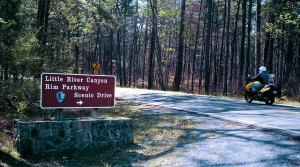
Leaving Little River Falls it’s back on 35 northwest a short distance to Route 176 west. Maurice and I took a left on 176 and began a leisurely ride around the western rim of the canyon. There are eight overlooks along the way to stop, take pictures, rest, eat a packed lunch and just take it all in. By the time we passed Mushroom Rock, I was thinking about how enjoyable it is just taking it easy riding through this place. As a member of the Honda Sport Touring Association (HSTA), I’m a sport-touring-type of rider, so when I see a set of curves up ahead I usually feel a shot of adrenaline and get ready for a quicker pace.

Farther down the road, Grace High Falls Overlook provides a view of yet another waterfall, this one 104 feet high but seasonal. Finally we came upon the cutoff to Route 275, which leads to Canyon Mouth Park (CR 275 is not listed on every map). We considered the signs and literature warning against taking this route, due to the road being rough and steep. But this fork in the road looks inviting so we decided to travel down it anyway knowing that we would simply turn around if the road conditions became too treacherous for our motorcycles.
Everything went fine for a couple of miles. The road was rough, but nothing a Suzuki V-Strom and Bandit couldn’t handle. It all came to an end, though, when we met a truck parked in the road. A stern-looking man with an attitude told us to turn around. He claimed he was a road worker, but we didn’t see any road work going on behind him. I thought about pressing on anyway, but decided it was best to simply take another route to Canyon Mouth Park. It may be that 275 south would be a great road to take a dual-sport bike on some other day.

We traveled back and continued down 176 west and had lunch at The Big Time Café, a somewhat modest-looking place that serves a good variety of tasty food. With a good meal in us we hopped back on the bikes and went east on Route 68 to 273 north. From the junction of 68/273 it’s about nine miles to the signs pointing to Canyon Mouth Park on the left. This is an excellent place to bring the family. There are plenty of shade trees, a pavilion, a beach, picnic tables, grills, restrooms and very calm water for wading in or fishing (with a license, of course). Canyon Mouth Park is a day-use area only.
Camping is permitted in three designated areas within the preserve, including Desoto State Park. Ask someone at Park Headquarters about areas to camp.
The Little River Canyon ride was very enjoyable for me. It’s a ride I plan to do again sometime, possibly with a dual-sport bike so I can give Route 275 a try. Cruising down Canyon Rim Parkway (176) I can’t remember seeing a house or a side road anywhere. There was simply great scenery, curves, the canyons and the waterfalls, with plenty of peaceful solitude to be found at the end in Canyon Mouth Park. If you’re ever in the area, I encourage you to give this ride a try.


