


The Cherohala Skyway doesn’t demand attention the way some of Appalachia’s more famous motorcycle roads do. There are no souvenir shops celebrating impossible corner counts, no crowds gathered to watch riders pass, and very few reminders that you’re traveling one of the Southeast’s premier motorcycle routes. Instead, the Skyway quietly rewards those willing to slow down and explore.
Running 43 miles between Robbinsville, North Carolina, and Tellico Plains, Tennessee, the National Scenic Byway climbs from river valleys into the highest elevations of the Cherokee and Nantahala national forests before descending back toward civilization. The road was decades in the making and ultimately cost more than $100 million to complete, but today it’s known less for its construction than for the remarkable riding experience it delivers.
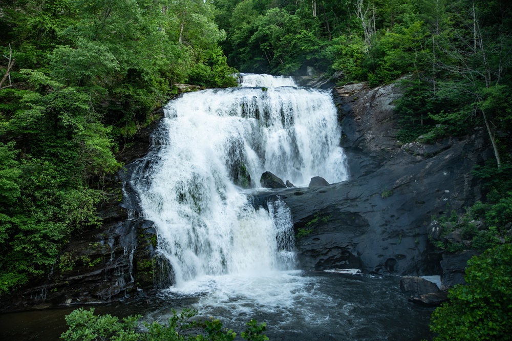
Unlike many Appalachian roads that cling to creek bottoms before winding through narrow gaps, the Cherohala spends much of its journey riding the ridgelines themselves. Long stretches remain above 5,000 feet, where hardwood forests give way to sweeping mountain panoramas and cool temperatures linger well into summer.
One of the first stops worth making is Santeetlah Overlook on the North Carolina side. From here, riders can look back across Lake Santeetlah and the surrounding mountains that seem to ripple endlessly toward the horizon. Early mornings often bring low clouds filling the valleys below, creating the illusion that the peaks are floating on a sea of white.
Farther west, Hooper Bald offers one of the Skyway’s more unexpected attractions. A short walking trail leads to an open grassy summit, a rarity in these heavily forested mountains. In June, flame azaleas and rhododendrons burst into bloom, adding vibrant color to an already spectacular viewpoint. On clear days, visibility stretches for dozens of miles.
Near the Tennessee state line, Huckleberry Knob provides another worthwhile side excursion. At more than 5,500 feet, it’s one of the highest grassy balds in the eastern United States. The hike is relatively easy, making it an excellent way to stretch your legs before continuing the ride.
Wildlife sightings are common throughout the corridor. White-tailed deer frequently appear near dawn and dusk, while wild turkeys, black bears, and countless bird species inhabit the surrounding forests. Riders should stay alert, particularly during the quieter morning and evening hours when animals are most active.
While the Skyway itself is fully paved, the surrounding national forests offer endless opportunities for adventure riders. Numerous Forest Service roads branch away from the highway, leading to secluded campsites, mountain streams, and forgotten fire towers. Roads like Forest Service Road 81 and North River Road which introduce riders to the quieter side of the southern Appalachians, where gravel replaces pavement and traffic often disappears entirely. These routes vary in condition throughout the year, making them best suited for dual-sport and ADV motorcycles.
Those staying on pavement have plenty of options as well. At the eastern end of the Skyway, NC 143 connects with NC 28, better known as Moonshiner 28, opening the door to another full day of exceptional riding through western North Carolina. A short ride south leads to Deals Gap and the Tail of the Dragon, while heading north uncovers lesser-known gems like Joyce Kilmer Road and winding routes around Lake Santeetlah.
On the Tennessee side, Tellico Plains serves as an ideal basecamp. The small mountain town has embraced touring riders without losing its laid-back character. Before leaving town, many riders stop at the Charles Hall Museum, which showcases Appalachian history through an eclectic collection of vintage automobiles, motorcycles, logging equipment, and local artifacts. Nearby, the Tellico Grains Bakery has become something of a tradition for riders fueling up before tackling the day’s miles.
One of the Skyway’s greatest strengths is that it encourages exploration rather than simply passing through. Pullouts appear frequently, many requiring only a few minutes to appreciate a different perspective of the mountains. On weekdays, it’s entirely possible to ride several miles without encountering another vehicle, allowing the road’s sweeping curves and constant elevation changes to become the focus.
Seasonal changes continually reshape the experience. Spring fills the forests with blooming dogwoods and rhododendrons. Summer offers welcome relief from the heat at higher elevations, where temperatures can be 10 to 15 degrees cooler than the valleys below. Autumn transforms the entire corridor into one of the Southeast’s premier destinations for fall color, while winter closures occasionally occur during snow or ice events.
The Cherohala Skyway isn’t a road that needs to prove itself with technical challenges or record-setting statistics. Its appeal comes from something simpler – uninterrupted mountain scenery, beautifully maintained pavement, and countless opportunities to wander beyond the main route.
Travel Resources
Click here to view the route on REVER
Click here to download the GPS file
At a Glance
Location: Eastern Tennessee and Western North Carolina
Distance: Approximately 51 miles
Ride Time: 1.5-3 hours (not including overlooks and stops)
Speed Limit: 35-45 mph
Best Direction to Ride: Eastbound or westbound
Skill Level: Beginner to Intermediate
Best Bike Type: Sport-touring, touring, ADV, standard, sportbike
Road Conditions
The Cherohala Skyway is fully paved and exceptionally well maintained, with smooth asphalt and broad, flowing curves that encourage consistent rhythm riding. Unlike many older Appalachian roads, the Skyway was engineered specifically as a scenic mountain highway, resulting in generous sight lines and gradual transitions between corners.
The route climbs above 5,300 feet, bringing substantial elevation changes and cooler temperatures. Weather can shift rapidly at altitude, especially during spring and fall. Fog is common during early mornings, and wet pavement or scattered debris may appear after storms. Wildlife crossings, including deer and black bears, are possible throughout the corridor.
Traffic is generally lighter and less chaotic than nearby U.S. 129, though weekends and peak fall foliage season bring increased motorcycle and tourist activity. Fuel and services are unavailable on the Skyway itself, so riders should plan accordingly before entering the route.
When to Travel
Late spring through fall is the prime riding season for the Cherohala Skyway. May and June bring cool mountain air, lush forests, and relatively light traffic, while October transforms the route into one of the Southeast’s premier fall-color rides.
Summer temperatures remain pleasant at elevation, though afternoon thunderstorms are common in the mountains. Winter can bring snow, ice, and temporary closures, particularly along the highest sections of the road. Riders should always verify weather and road conditions before departure during colder months.
Weekdays offer the most relaxed experience, especially during autumn tourism season when the region becomes extremely popular. Early mornings provide the clearest air and lightest traffic but may also bring dense valley fog and colder temperatures. Layered riding gear is strongly recommended year-round due to rapid elevation-related temperature swings.
Road Food
Both ends of the Cherohala Skyway are well adapted to motorcycle tourism. Tellico Plains offers several rider-friendly diners and cafés serving classic Southern breakfasts, barbecue, burgers, and comfort food before heading into the mountains.
On the North Carolina side, Robbinsville has become a major basecamp for riders exploring the Smokies. Local restaurants cater heavily to motorcycle traffic, and it’s common to see parking lots filled with touring bikes and sportbikes throughout the riding season.
Nearby Deals Gap also offers classic rider-stop culture with food and souvenirs. Services along the Skyway itself are nonexistent, so riders should fuel up and carry water before riding the route.
Here are a few of our favorite places to eat:
- Tellico Beach Drive-In
A classic roadside burger stand and longtime local favorite known for milkshakes, hot dogs, and laid-back small-town atmosphere just minutes from the Cherohala Skyway. - Tellico Grains Bakery
Popular with riders for its fresh-baked bread, pastries, pizzas, and cafe-style breakfasts served inside a restored historic building downtown. - Iron Works Grille
A rider favorite along the Tellico River offering burgers, Southern comfort food, and outdoor seating that makes an ideal post-Skyway stop. - Tellicafe
A classic Southern diner near the western entrance of the Cherohala Skyway known for generous portions, hearty breakfasts, and motorcycle-friendly parking. - Tapoco Tavern
One of the Smokies’ most iconic motorcycle stops, featuring riverside dining, mountain scenery, and easy access to both the Cherohala Skyway and Tail of the Dragon. - Lynn’s Place
A small-town diner known for hearty Southern breakfasts and comfort food that has become a staple stop for riders exploring western North Carolina.
Where to Stay
Robbinsville and Tellico Plains both offer excellent lodging options for riders using the Cherohala Skyway as part of a larger Appalachian motorcycle trip. Small motels, rider-focused lodges, cabins, campgrounds, and rental homes are common throughout the region.
Robbinsville serves as one of the primary motorcycle hubs in western North Carolina thanks to its proximity to the Tail of the Dragon, Moonshiner 28, and the Cherohala itself. Many accommodations offer trailer parking, covered motorcycle parking, and group-friendly layouts.
Camping is widely available throughout the Cherokee and Nantahala national forests for riders seeking a more immersive mountain experience. Reservations are highly recommended during peak foliage season and major motorcycle event weekends, when the region fills quickly.
Here are a few of our favorite places to stay:
- Cherohala Mountain Trails Campground
Popular with ADV and touring riders thanks to its tent camping, cabins, rider-friendly atmosphere, and close proximity to the Skyway. Frequently used as a basecamp for multiday Smoky Mountain riding trips. - 129 Cabins
A motorcycle-friendly cabin option near the Smoky Mountains in Robbinsville, North Carolina, offering a laid-back basecamp right along the legendary US 129 riding corridor. - Cherohala Skyway Cabins
Quiet mountain cabins near Tellico Plains featuring covered motorcycle parking, hot tubs, and direct access to the Cherohala riding corridor. - The Lodge at Tellico
A rider-owned lodge designed specifically for motorcyclists, complete with secure bike parking, wash stations, group gathering spaces, and quick access to the Cherohala and Tail of the Dragon. - Iron Horse Motorcycle Lodge
One of the Southeast’s best-known motorcycle lodges, offering cabins, camping, meals, and a rider-focused atmosphere near Robbinsville and the Tail of the Dragon. - Dragon’s Rest Cabins
Motorcycle-friendly mountain cabins near Robbinsville catering specifically to riders exploring the Cherohala Skyway, Moonshiner 28, and U.S. 129. - Blue Boar Inn
A quiet mountain inn near Robbinsville that serves as a comfortable basecamp for exploring western North Carolina’s famous motorcycle roads. - Snowbird Mountain Lodge
A historic, all-inclusive mountain lodge overlooking Lake Santeetlah and the Nantahala National Forest, offering rustic cabins, fine dining, and a quiet, upscale retreat just outside Robbinsville that’s perfect for riders looking to unwind after a day on the Cherohala Skyway.
Points of Interest
- Cherokee National Forest
- Nantahala National Forest
- Tail of the Dragon (U.S. 129)
- North Carolina Highway 28 (Moonshiner 28)
- The Foothills Parkway
- Bald River Falls
- Santeetlah Lake
- Joyce Kilmer Memorial Forest
- Scenic mountain overlooks along the Skyway
- Deals Gap motorcycle resort area
If You Have More Time
The Cherohala Skyway works best as part of a larger Southern Appalachian riding loop. Riders can easily combine it with the Tail of the Dragon, Moonshiner 28, the Blue Ridge Parkway, and countless lesser-known mountain connectors across Tennessee and North Carolina.
For riders seeking more technical pavement, nearby State Route 28 offers tighter corners and denser forest riding. Those looking for scenic cruising can continue eastward toward the Blue Ridge Parkway for long-distance ridge riding through the Smokies.
This entire region rewards exploration beyond the marquee roads. Some of the best riding experiences come from wandering the unnamed forest highways and mountain backroads connecting the major routes together.






You can also stay with us! Tinyurl.com/hikershaven560 – it’s a great ride and a fun area!
Including the speed limit would be helpful.
45-motorcycle cops are assigned here sooooo.