story and photography by Kenneth W. Dahse
There’s nothing more adventurous and satisfying than hitting the road for a few days, especially if the route you choose offers good motorcycling and a variety of sights and experiences. We love riding country routes that lead to lakes, rivers, small towns and state parks, and take us past lush farmland. Cruising the back country roads of northern New Jersey, northern Pennsylvania, and southern New York State offers riders one such adventure.
I began my tri-state odyssey in New Jersey, sailing along Sloatsburg Road, through Ringwood State Park to the curvaceous forest-rimmed Long Meadow Road. I took it north through 17,000-acre Sterling Forest State Park. At 17A, I turned right and connected with 17 North. To save time on the first leg of this adventure, I decided to superslab it on Routes 17 and 84 to Lake Wallenpaupack, my first night’s destination. This 13.5-mile-long lake covers 5,700 acres and has 52 miles of shoreline. Tour boats, rentals, swimming, fishing and water skiing are all available, and numerous resorts ring the lake. I stayed at Gresham’s Lakeview Motel, which is clean but in need of some upgrades. Gresham’s Chop House Restaurant next door has views of the lake from both inside and outside dining areas, serves decent food and has a cozy bar.
After I dumped my gear, I rumbled along Route 6 to 590 East, then 3028 to the Triple “W” Horse Riding Stable. Trading my steel steed for a real one, I felt like a “High Plains Drifter,” galloping across the mountain meadow. That evening back at the lake I walked to the dam and boat dock, appreciating the sound of the soothing waves lapping the shoreline, as well as the solitude.

The next day I fired up my Kawasaki Vulcan Nomad 1600 and headed west on Route 6 through Hawley, a small town with western-style architecture, on to Honesdale and the Baer’s Harley-Davidson dealership. A worthwhile stop, even though they had more clothes than bikes on display. Rolling into Waymart, I noticed wind turbines on its mountain ridge. These huge structures and their blades slice into the horizon, an impressive sight and far less obnoxious than billowing smokestacks. Deciding to bypass Scranton, I took Routes 106 and 11 North to 706 South to Wyalusing. My Nomad ate up the roads as it sailed through the countryside, a tri-state odyssey of small towns, farms, country churches and lush scenery before reconnecting with Route 6 at Wyalusing.
Just west is the Wyalusing overlook, which sits 500 feet above the Susquehanna River. It was once used by the Iroquois Indians as a signaling point. Cruising into the parking lot, I dismounted the Vulcan. I stood on the rock cliffs and gazed down at the Susquehanna River flowing slowly through the farmland, feeling like I was on top of the world. Another impressive view right off Route 6 is the Marie Antoinette Lookout, which offers an eagle’s observation of the site where French refugees built a colony in the late 1700s.
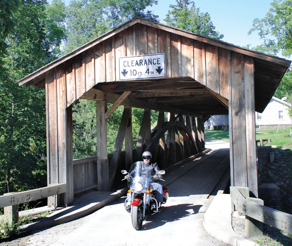
After enjoying the views, I fired up the Nomad and rumbled west. The warm sun caressed my face as the sweet Pennsylvania wind whispered in my ears. At Luther Mills, I followed signs to Knapp’s Covered Bridge. Riding on packed dirt roads through the hinterlands of Pennsylvania, I felt like a lone cowboy riding the high country. At the bridge, I enjoyed listening to the bubbling brook while breathing in the unique scent of recycled pasture grass. Nothing says country more than cow manure.
Returning to Route 6, I continued my journey westward toward Pennsylvania’s “Grand Canyon” country. I rolled through Mansfield and then picturesque Wellsboro. That it was originally settled by New Englanders explains why Wellsboro looks more like a New England town rather than a central Pennsylvania one. A delicious and reasonably priced meal at the clean, classy country Wellsboro Diner was testament to everything good about the prefab railroad- style diners of yesteryear. Unfortunately they’re being drowned into extinction by an expanding sea of fast-food restaurants.
From Wellsboro, I rode west to The Coach Stop Inn, my home for the next two nights. Built in 1832, the Inn served as a coach stop, and subsequently as a tavern, store, post office and even as a hiding place for runaway slaves. The Inn has a restaurant, bar and recently built motel units. It is a great jumping-off point for exploring the “Grand Canyon” of Pennsylvania, my next day’s destination.
I awoke to a cloudless, blue sky day. Having been to and hiked the Grand Canyon in Arizona, I was anxious to see if Pennsylvania’s was as grand as they claimed or if it was just tourist hype. The canyon is actually named Pine Creek Gorge and is best viewed from two state parks: Leonard Harrison State Park on the east rim and Colton Point State Park on the west rim. Leonard Harrison State Park has a visitor center, modern camping facilities, picnicking and a gift shop. Colton Point State Park has rustic camping and picnicking facilities. Both parks have easy rim trails to various overlooks.
American Indians called the canyon Teeahdotton, or River of Pines. For thousands of years, Pine Creek carved its way through the Allegheny Plateau, creating this 47-mile-long canyon, which is 1,450 feet at its deepest and is almost a mile wide. Although nothing can match the spectacular marvel of the “real” Grand Canyon, this one is still an impressive sight!
Walking the rim trails shot power into my legs and rich oxygen into my lungs, making the views seem even more incredible. The sound of the roaring rapids of Pine Creek floated up the canyon walls declaring their power, and a lush canopy of trees painted the mountains and canyon walls a vibrant green. Mother Nature had clearly demonstrated her creative power by carving such a lush gorge.
After visiting both rims, I wandered the empty roads that led to and from the parks, exploring farmland and forest. Taking a break, I reviewed the map. Pennsylvania is famous for some of its uniquely named towns such as Loyalsockville, Blue Ball and Intercourse. Seeing that a town named Germania was nearby, I decided to visit.
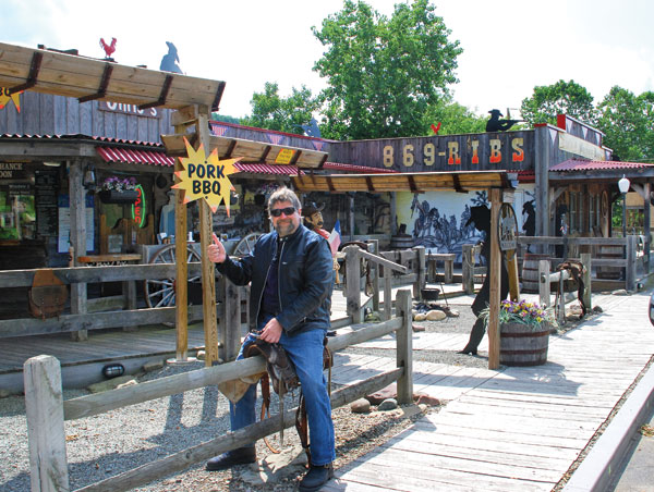
Obviously named for its German immigrants, Germania made a nice side trip. This thriving metropolis consists of a general store, a church, a few houses and a bar that look like something out of the old west. After a brief stop, I headed back to the Inn for dinner and to get a good night’s rest for my return trip.
Although Route 6 is one of Pennsylvania’s premiere motorcycling roads, snaking its way through small towns and farmland that feel more 19th century than 21st, it does suffer from congestion in places. So, for my return ride, I decided to bypass most of it and instead plunge deeper into the back country of rural Pennsylvania.

Firing up the Nomad, I headed east into the rising sun, slicing my way through the morning mist. At Wellsboro, I took Route 287 South to 414 East, traversing a section of motorcycling nirvana on virtually empty roads. At Canton, I turned onto Route 154 and then 87. Nearby is the World’s End State Park with its speculator view of Loyalsock Creek Gorge. By the time I reached Route 6 again, I was on sensory overload, having viewed so many villages and farms that I thought I had time- traveled to the 19th century. These roads made the two-lane Route 6 seem like a super highway.
Leaving Route 6 again, I rolled north on the forest-enveloped Route 92 to Smiley and connected with Route 2034, a challenging (parts are unpaved) but scenic road. Then I sailed along 374 to the spectacular 371 and Damascus. At its boat launch site, I grabbed a little shut eye on the banks of the pristine Delaware River before crossing the bridge into New York state. The river offers opportunities to swim, fish, kayak, canoe and raft. Route 97 parallels the river for over 80 miles and is one of the best motorcycling roads in the Northeast.
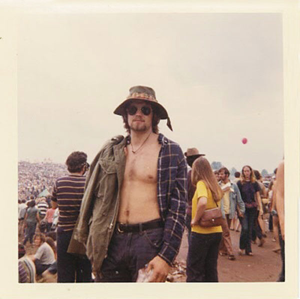
With several hours of daylight left, I decided to make a pilgrimage to the Woodstock Festival Site, which is now home to the Bethel Woods Center for the Arts. Bethel’s museum depicts the turbulent 1960s and a monument that honors the infamous 1969 “Three Days of Peace and Music” Woodstock Festival, where 400,000 young people gathered, creating an event like no other.
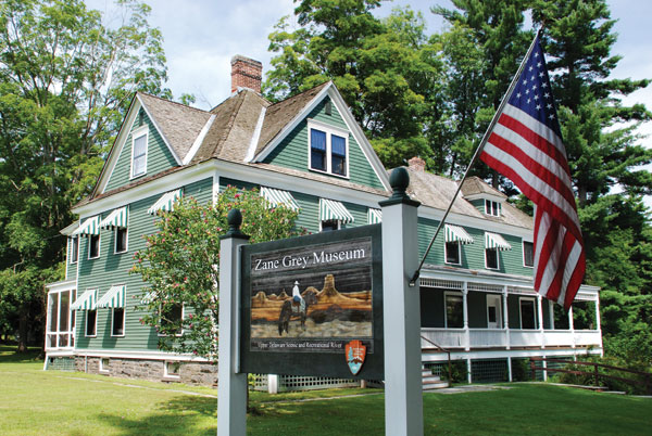
From Bethel, I took 17B to Route 55 South, cruising Sullivan County’s high country to Route 97. Nearby is the Zane Grey Museum where he wrote his famous western novel, Riders of the Purple Sage, among others. Just before Port Jervis, Route 97 cuts into the mountainside high above the river, giving you a “hawk’s nest” view of the river below. The Hawk’s Nest is a popular rider stop, and it’s not uncommon to spot hawks sailing across the horizon.
From Port Jervis it was smooth running through the lush Black Dirt farming region of New York’s Orange County and then into the highlands of New Jersey. I thundered by Wawayanda State Park with its bountiful blue lake and expansive sand beach, and then did a scenic circular around the mountain-ringed Greenwood Lake, which brought me to the end of my journey.
And what a journey it had been. I experienced mountains, farmlands, small towns, lakes, horses and a spectacular canyon. And, I did it all while rambling along rolling backroads on a tri-state odyssey.


