In late September, I joined my riding buddies Ray, Rafi, Ashish, and Jay for a northern Wyoming motorcycle ride through wild landscapes, including the Chief Joseph Scenic Byway, Beartooth Highway, and northern Yellowstone National Park. In motorcycle touring’s purest form, we set out to celebrate the harmony between rider and machine, the rugged beauty of the American West, and the camaraderie found among fellow riders out on the open road.
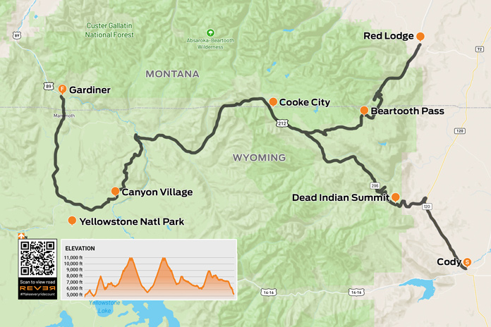
Scan QR code above or click here to view the route on REVER
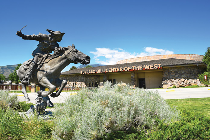
We began our journey in Cody, a northern Wyoming town founded by cowboy legend “Buffalo Bill” Cody. Born in 1846, Buffalo Bill was an American soldier, bison hunter, and showman, best known for his traveling Wild West shows. Today, the town still embraces its Wild West roots. While there you can tour the Buffalo Bill Center of the West, a superb display of life in the Old West. The center has five museums: the Buffalo Bill Museum, which is about his life and times; the Plains Indian Museum, which showcases art and heritage; the Draper Natural History Museum, highlighting the ecosystems of Yellowstone; the Whitney Western Art Museum; and the Cody Firearms Museum.
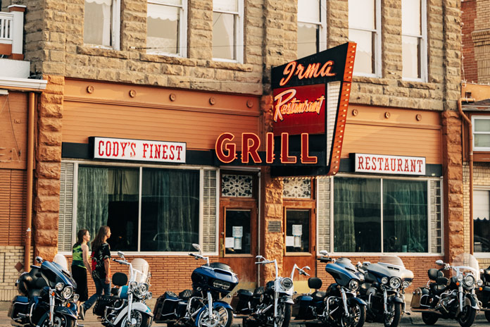
Along with the American West atmosphere, there are plenty of lodging and dining options. You can get a room at the cozy A Western Rose Motel on Sheridan Avenue, which is the main downtown street. From there you can walk down to the Irma Hotel for dinner. Buffalo Bill Cody built the Irma in 1902 and named it after his daughter. The hotel menu has an appetizer called Rocky Mountain Oysters – Buffalo Bill’s Original Sack Lunch.
Known as the Rodeo Capital of the World, Cody has a rodeo every night in June, July, and August. The town is a great place to kick back for a few days and experience its unique charm, activities, and amenities. Cody also serves as a great base camp for day rides. To the east, there’s the Medicine Wheel Passage Scenic Byway (U.S. Route 14A), Bighorn Scenic Highway (U.S. Route 14), and the Sweet 16 (U.S. Route 16) through the Bighorn Mountains.
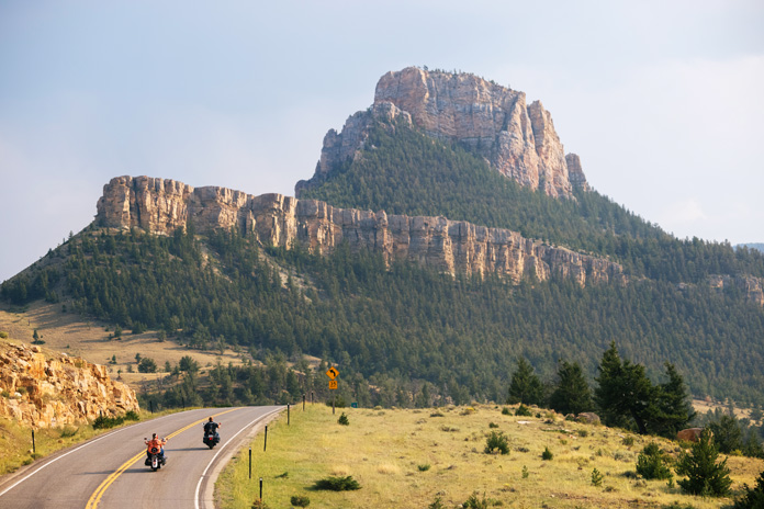
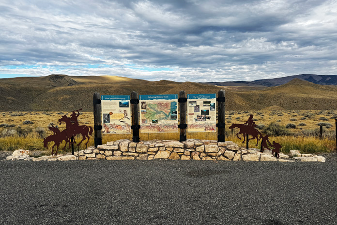
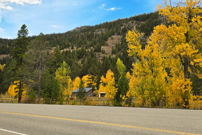
From Cody, we rode northwest on Belfry Highway (State Route 120) to reach Chief Joseph Scenic Byway (State Route 296), which loosely follows the 1877 escape route of Chief Joseph and the Nez Perce Tribe as they fled the U.S. Cavalry. The 47-mile-long byway delivers dramatic views of the Absaroka and Beartooth Mountains, Sunlight Basin, and the Clarks Fork Valley.
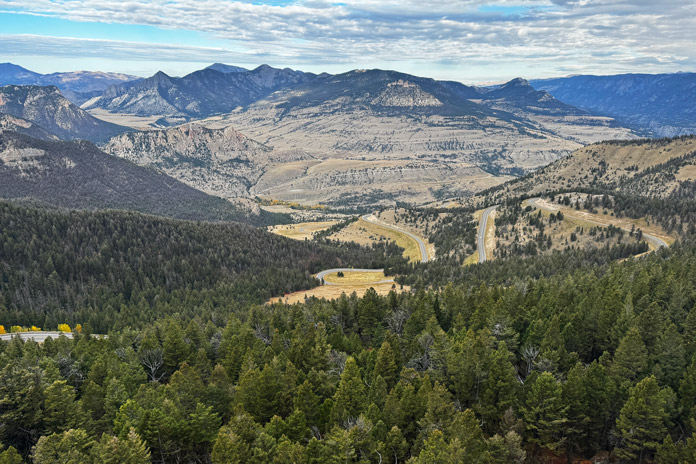
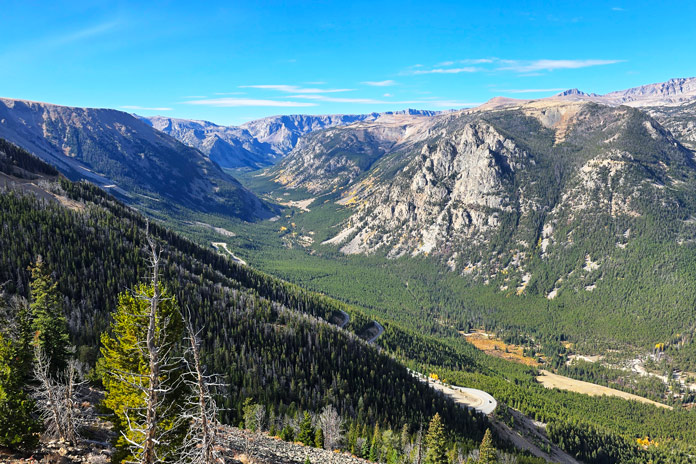
The road began gently, giving us ample time to soak in the scenery, but soon sharpened into steep climbs and gnarly switchbacks leading up to Dead Indian Summit. The overlook is a must-stop, providing expansive views of the Clarks Fork of the Yellowstone River, the surrounding wilderness, and the highway snaking below. The following descent featured more tight hairpins before easing into long, wide, flowing corners that carried us toward our next adventure.
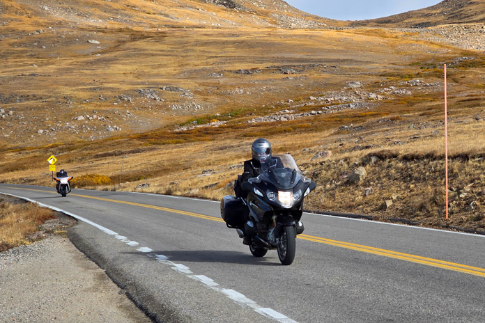
Renowned CBS broadcaster Charles Kuralt called the Beartooth Highway (U.S. Route 212) “the most beautiful drive in America.” It’s the highest-elevation highway in Wyoming and the Northern Rockies, winding through expansive wilderness filled with forested valleys, high alpine plateaus, and countless glacial lakes. A perfect mix of tight corners and wide sweepers exemplified the synergy between riders and their steel steeds as we climbed toward a summit that felt like the top of the world. Riding ahead of the season’s first snowfall meant the pavement was smooth and clean. Note: The Beartooth Highway can be closed due to heavy snow at almost any time of year and is typically shut down from mid-October through mid-May.
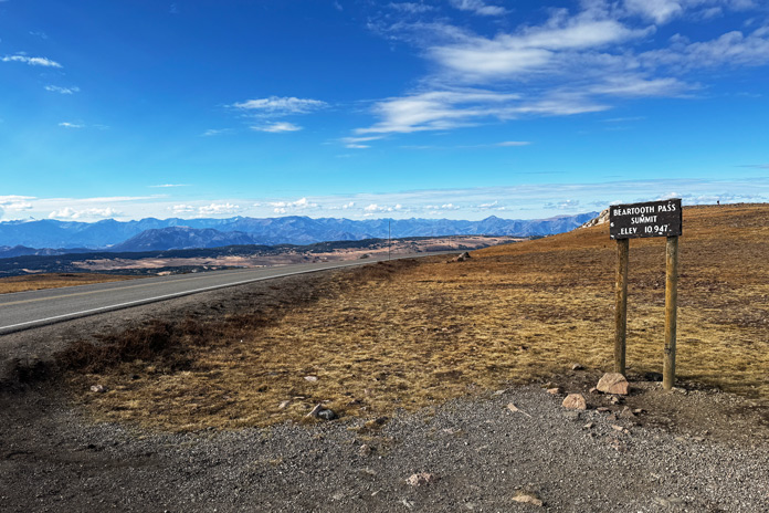
We passed the aptly named Top of the World Store, which had already closed for the season. A pity: I would’ve grabbed a T-shirt. Now above the tree line, we paused at Beartooth Pass (10,947 feet) to take in the breathtaking 360-degree view, then continued a few more miles to Rock Creek Vista Point, a must-see overlook with jaw-dropping views of Rock Creek Valley and the Hellroaring Plateau. Naturally, we crossed paths with other riders in the parking lot, all of us wearing the same ear-to-ear grins as we relived our day so far.
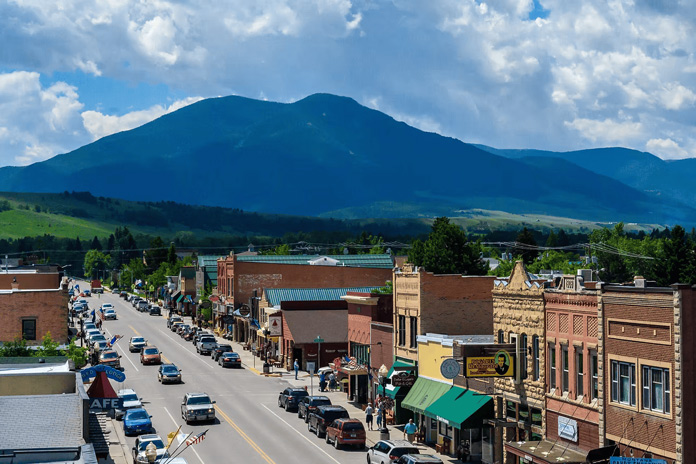
The journey along Beartooth Highway ends in the welcoming mountain town of Red Lodge, Montana, which offers small-town charm nestled within the breathtaking scenery of the Rockies. Sitting at nearly 5,600 feet in elevation, Red Lodge is the perfect landing spot after climbing to almost 11,000 feet over Beartooth Pass. It’s the kind of place where you can settle in for a hearty meal and a cold libation while replaying the dramatic views with friends. You will want to spend the night to truly catch your breath after an unforgettable ride through the clouds.
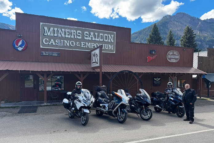
Yellowstone National Park was our next destination, so we returned to the summit and zoomed back down the mountain, retracing our route and enjoying Beartooth Highway all over again. From the junction with SR-296, we continued west on U.S. 212 to Cooke City, an isolated, forest-wrapped mountain town just outside Yellowstone’s northeast entrance, where we enjoyed a well-earned rest. Cooke City is a great little gateway community with options for lodging, dining, groceries, gas, and more.
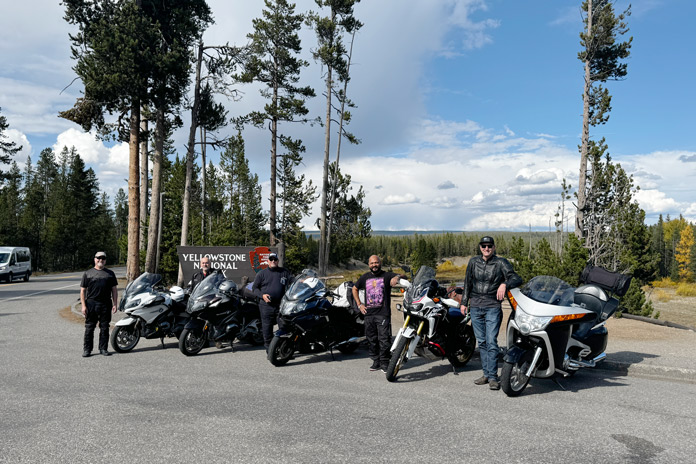
A few miles west of Cooke City, we paid our way into Yellowstone and crossed back into Wyoming on Northeast Entrance Road, which follows Soda Butte Creek and passes through Lamar Valley – one of the best areas for wildlife viewing.
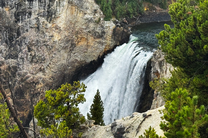
At Tower Junction, we turned south on Grand Loop Road and enjoyed a leisurely cruise through America’s (and the world’s) first national park, founded in 1872. We turned left onto North Rim Drive, which follows the Grand Canyon of the Yellowstone, a 20-mile-long ravine sculpted by the Yellowstone River. This area was much more crowded than our earlier stops, so parking our bikes required creativity. The short descent down the Brink of the Lower Falls Trail, motorcycle boots and all, was worth it for a close-up view of the 300-foot-tall Lower Falls thundering below.
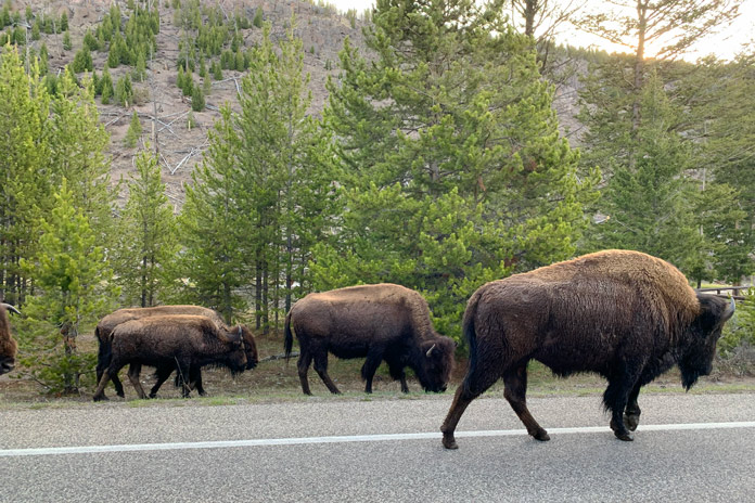
We grabbed ice cream at Canyon Village, where Ray ran into some old friends. Small world. Those wildlife warning signs proved all too real. Midway through a sweeping right turn, I came face to face with a massive bison standing on the edge line, exactly where I was riding. I slipped by with just inches to spare.
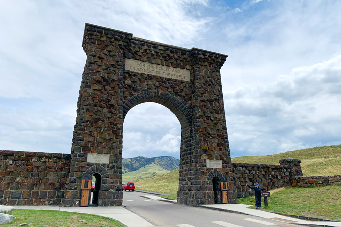
We continued west through the park along Norris Canyon Road, eventually reconnecting with Grand Loop Road, stopping at various turnouts to enjoy the views, fall colors, wildlife, and the sulfur-tinged aroma of geothermal vents scattered across the landscape. From there, we headed north through Mammoth Hot Springs and on to the Roosevelt Arch, whose cornerstone was laid down by President Theodore Roosevelt in 1903 at the park’s north entrance. Our adventure ended in Gardiner, Montana. Note: Several roads in this part of Yellowstone, including sections of Grand Loop Road and Norris Canyon Road, are closed during the winter.
This ride in northwestern Wyoming ranged in elevation from 5,300 feet to almost 11,000 feet. Along the way, we experienced vast mountain vistas, alpine tundra, glacial lakes, and forested valleys. We tackled steep climbs, wicked switchbacks, endless sweeping corners, and one enormous bison. It was the pinnacle of what a great motorcycle ride should be.
See all of Rider’s touring stories here.
Northern Wyoming Motorcycle Ride Resources
- Wyoming Tourism
- Cody, WY
- Montana Tourism
- Montana’s Yellowstone Country
- Red Lodge, MT
- Cooke City, MT
- Gardiner, MT
- Yellowstone National Park
Andrew Fodor is a software engineer who lives in Southern California. Motorcycling has been his favorite hobby for over 30 years, and he regularly explores California’s coast and mountains as well as longer tours to nearby states.


