The following is an excerpt from the article North Georgia Colors printed in the April 2007 issue.
Tear it out and take it with you, or print the pdf version you can find by clicking here.
To anyone who rides a motorcycle in the Southeastern United States, the roads of North Georgia into Southern Tennessee and North Carolina are well known and frequently ridden. Much of the three-state area is contained within national forests, protected and pristine, and any weekend day will find riders taking in the curves and scenery in three seasons.

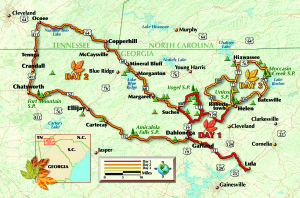
* Highway 19 north out of Dahlonega leads to State Route 60 toward Suches. Caution is necessary as it is a ribbon of tight S-curves and decreasing-radius turns over its entire length. With an alert and confident rider, however, this road can return some of the best riding experiences you are likely to have on a motorcycle. Scenic vistas sight to the horizon, with spectacular views of the Blue Ridge Mountains regardless of season. Approximately 5 miles up, a look to the left into the area known as Woody Gap will reveal a great expanse of multicolored forest, with Springer Mountain rising in the distance. Other stops feature information on local Civil War battles, Native American history, gold-mining sites and hiking trails.
* The “Georgia Triangle” is a well-known riding circuit in this area. The triangle consists of three roads—State Route 60 to State Route 180, then back to Highway 19, which heads south to the origin point for a 37-mile round trip.
* State Route 180 is the most challenging portion of the triangle. It is a mind-boggling road you don’t want to miss, but take it at a deliberately leisurely pace the first time through. The road begins as sedate two-lane blacktop leading to Lake Winfield Scott, a small scenic lake that acts as a reflecting pool for the foothills that surround it. State Route 180 then snakes through the Sosbee Cove Scenic Area with 10-mph speed limit signs on some curves and nary a straight-line section to be had. It is known for having more sharp curves and steeper grades than any other paved road in Georgia.

* Highway 19 south is the last leg of the triangle. Being a U.S. highway, it is wider with intermittent passing zones throughout, but like most of the roads in North Georgia, it is a continuous series of S-curves all the way down the mountain.
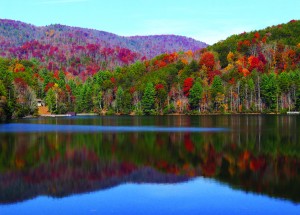
* State Route 52 is a lesser-known road in North Georgia, but is easily one of the most enjoyable, full of challenging twisties and scenic stopping points. A few miles past Ellijay, the road makes a right turn directly into the national forest. Here, as the road ascends, the sun shines through autumn foliage, bathing the entire 25-mile length of highway in a bright golden glow.
Note: Philip Buonpastore is the author of Shifting Gears at Fifty, A Motorcycling Guide for New and Returning Riders. The book ($24.95, BowTie Press) can help with choosing a size and style of motorcycle, and offers suggestions for acquiring experience on a bike and purchasing riding gear and accessories.
(This Great Roads article was published in the March 2013 issue of Rider magazine.)


That triangle is overused and no to my liking. The best part of 60 is from Blue Ridge to Suches. The road is a combination of valley roads set upon the hillsides, and crossing a beautiful piece of the Smoky Mountains. The ride from Suches to US 19 is ugly at best, and 180 is a cow path, best used by pick up trucks. US 19 to Dahlonega is very good however.
The Mountain Parkway begins near Marietta, and is a fast ride to Blue Ridge. GA 60 to US 19 and ride to state GA 52 which is one of the most picturesque roads through the park areas. After passing Amicoloa Falls entrance there is a major intersection with GA 183. Turn left for several block to GA 136 across Burnt Mountain to Jasper (on the Mountain Parkway). This the best day of riding I’ve ever had.
Burnt Mountain is not to be missed. I make it a point to ride across 136/52/183 every time I go to Georgia.