The name Las Vegas is generally associated with glitzy gambling in Nevada and Sin City, the fastest-growing city in the United States. But there is another Las Vegas that sits quietly in north central New Mexico along Interstate 24, east of Santa Fe.
Las Vegas (Spanish for “fertile valleys”), New Mexico, was founded in 1835 and is a diverse community with a population of just 14,565. On the edge of the Sangre de Cristo Mountains, it is a great hub for motorcycle touring. Accommodations range from the swanky Plaza Hotel built in 1882, to RV and tent sites at Storrie Lake State Park.
Like the state bird of New Mexico, the roadrunner, I would use the next few days to run the area’s roads, using this quieter Las Vegas as home base. It didn’t take long to learn that the food is as varied as the area’s cultures, and that most everything can be soaked in green chilis. Yummmm….

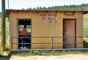
For Ride One, from Las Vegas I headed north on Highway 518 to La Cueva to see the Romero Ranch house built in 1851 and its gristmill. The area is now home to the Salman Ranch—a store, café, “U-Pick It” raspberry farm and nursery—that sit beside the old stone walls of the ranch. Highway 518 is not exactly a major thoroughfare, but when I turned north on Highway 442 at La Cueva, I moved even farther off the beaten path as I rolled through valleys and into the hamlet of Ojo Feliz (Spanish for “happy eye”). The size of its post office gives an idea that you’re not on the outskirts of that other Las Vegas.

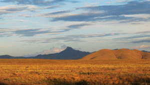
At Ocate, about 22 miles up Highway 442, I had to turn either east or west. Ocate is so small, it is listed simply as a “populated place.” Then I noticed a building across the road to the left with a sign that read “Mountain Wood Art Gallery,” so I rode over and went in. It’s not an art gallery. Tony lives behind the small store and keeps it open to visit with the folks who stop by for the few items he stocks (pop, candy, oil, toilet paper, ice cream—it’s 50-plus miles back to Las Vegas and the grocery store). He was eager to talk about current events. The conversation was enchanting and a little disorienting, but enjoying the unexpected is one bonus of getting out of the cage to see our country. I asked Tony about taking Highway 120 west to Black Lake but he shook his head. Seems Highway 120 west is a gravel/dirt road that turns into a rough rock/gravel/wash-out kind of road that slices through the mountains with no cell phone service. I’d not had to pick up my Suzuki V-Strom yet and didn’t want to, so I turned east on Highway 120 through golden plains and sunflowers nodding in the wind and was soon in Wagon Mound, at the intersection of Highway 120 and Interstate 25, a village with a population of 350.
The gypsy gods smiled, and I rode into Wagon Mound on Bean Day, their annual Labor Day festival. There was a parade, rodeo, free beans, local entertainment and small-town vendors.
After enjoying a bean burrito laced with green chilis, I headed south on I-25. But it was still early, so I turned west at Waltrous on Highway 161 and ended up back on Highway 518, about 25 miles north of Las Vegas. An easy 120-mile day through fertile valleys.
Ride Two

I was heading north to Cimarron to check out an old cowboy bar with bullet holes in the ceiling. From Las Vegas, I rode north on I-25, and after about 70 miles on the slab, turned west at Springer on Highway 21. I chose Highway 21 rather than the more-traveled Highway 58 a bit farther north because…well, Miami is on Highway 21, and I’m from Florida. Trust me, Miami, New Mexico, is not the same as the megalopolis sitting on the south end of Florida, and that’s a compliment.
On Highway 21 I stopped for a picture of pronghorns running and then watched a coyote watching me. While in this remote spot, two pickups stopped to see if I needed help. It’s good to be reminded of the kindness of strangers. Then I continued west through Philmont Scout Ranch, 214 square miles of rugged wilderness.
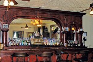
The St. James Hotel in Cimarron is the place “where outlaws ate, drank, and shot each other.” The tin tile ceiling in the bar still sports multiple bullet holes. Some of its famous patrons have included Wyatt Earp, Jesse James, Buffalo Bill Cody and Annie Oakley. With dead cowboys walking around at night, it’s also the best-known paranormal hotspot in the world. I was there too early for lunch, so I just wandered around and then rode away.
I turned west on Highway 64 and the road began to climb and twist its way into the Cimarron Range. The eastern run had not received much attention from road crews, so it required mine at slower speeds; west from Cimarron State Park the road is well paved, leaving more attention for the joy of riding. I stopped at the cliffs at Palisades Sill and ate my PB&J sandwich beside a mountain creek. At Angel Fire I was riding at 8,253 feet on good roads—and smiling.

The Vietnam Veterans Memorial State Park on the outskirts of Angel Fire was the first major Vietnam memorial in the United States, built by the parents of Marine First Lieutenant David Westphall after their son was killed in the War. The chapel overlooks the Moreno Valley in the Sangre de Cristo Mountains; in its quiet simplicity, it is a parents’ call for peace and brother- hood. Built in love with broken hearts, it was designed as a safe place for grown men to remember and cry. The memorial is one of the first stops of Run for the Wall riders, en route to Washington, D.C.
From Highway 64, I turned south on Highway 434 to pass through the ski resort of Angel Fire. At Black Lake you could take Highway 120, the offroad route that runs east to Ocate and Tony’s store, but I followed Highway 434 south as it ducked into forest—five miles on a narrow road with no center line, no shoulder, but plenty of pot holes and heaves with crumbly edges. The road is full of twisties but is not a ride to push hard; there is no cell phone service and little traffic. From Coyote Creek State Park south the road is well maintained as the world flattens and straightens into Mora Valley. At Victory Ranch, you can feed the alpaca and shop in the clothing/gift store. At the Tapetes de Lana, a cottage industry at the intersection of Highway 434 and 518 in Mora, local women weave wool from alpaca and sheep; their handiwork is available for purchase.
I headed back to Las Vegas—a 200-mile day of pronghorns, bullet-riddled ceiling tiles, tears for unnamed losses, roads not taken, and women in a remote area creating a new life.


