story and photography by Mike Benham
[Maine Motorcycle Rides:The Rangeley Lakes Region was originally published in the May 2010 issue of Rider]
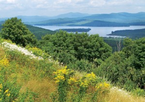
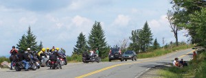
Within five miles of each other are two scenic overlook areas on Maine’s spectacular Route 17, a State and National Scenic Byway to the Rangeley Lakes region. On a northbound circuit, the first lookout is called the Height of Land, an elongated, widened area of the road’s western shoulder, at the location where the Appalachian Trail crosses the road after skirting around the northern flank of Brimstone Mountain. The views of the very wild-looking Mooselookmeguntic Lake, Cupsuptic Lake and Upper Richardson Lake are awe inspiring, with Maine’s western mountains as the lakes’ backdrop. Old Blue Mountain, Elephant Mountain and the long, undulating ridge of Bemis Mountain can be seen to the south and west across the steep drop to the very narrow Bemis Valley directly below.
The next lookout on our Maine Motorcycle Ride is Rangeley Scenic Overlook on the eastern side of ME 17. Rangeley Lake presents itself as if the center of a fine landscape painting, with the mountains to the north and east completing this canvas. Ephraim Ridge and Spotted Mountain are to the north, while Saddleback Mountain, The Horn and Potato Nubble are to the east.
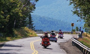
The views alone from these two scenic overlooks would make the ride north on ME 17 well worth it, yet this route is also a superb motorcycling road, one which it has been my pleasure to ride many times over the years. The road is never boring, with ample scenery and curves and mountain ascents and descents to keep you splendidly aware of what motorcycle travel is really about. One could easily think of ME 17 as a much rawer, rougher and wilder, isolated northern cousin of the Blue Ridge Parkway, which President Franklin Roosevelt had originally intended to run the full length of the Appalachians.
Getting to the area presents one with many options. A very quick way to access the region is to ride the Maine Turnpike, Interstate 95, to exit 63 at Gray, and then proceed north on ME 26. AAA maps mark most of ME 26 as scenic from Sabbathday Lake on up to Bethel, and then continuing on northwestward through Grafton Notch State Park to Upton. At Bryant Pond, leaving ME 26, I usually take ME 232 and some local roads to a crossing of the Androscoggin River, just west of Rumford. From Rumford and Mexico, off from U.S. 2, one proceeds north on ME 17.
Riding north from Rumford and Mexico, you chase up through narrowing farmland, climbing upstream along the Swift River valley. The mountains on either side of ME 17 start crowding the valley, and these mountains begin to rise from 2,000 footers to 4,000 footers at the Rangeley Lakes.
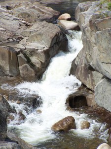
Swift River Falls is passed just north of the village of Frye. Coos Canyon comes next in the village of Byron. The metamorphic rocks in this canyon have been carved by the Swift River, and the swirls in the rock layers are an interesting sight. From what I have read, Coos Canyon rages with early spring runoff from mountain snowmelt. The roads up in this area can be pretty rough from frost heaves early in the spring, so I have not had the pleasure of seeing the Swift River at peak flow through Coos Canyon. About the earliest I make a ride to the area is mid- to-late-May, and anytime from mid-October on one can encounter sudden snow squalls.
After Coos Canyon ME 17 follows the now more gravelly Swift River for several miles before starting a very deliberate climb around Brimstone Mountain, with the pleasant Beaver Pond on its northern flank. This is followed by a curvaceous, continuing ride in the high country past the Height of Land and Rangeley Scenic Overlook. The road often swaps sides from the eastern or northern flank of one mountain, then swiftly drops into a saddle between peaks, then climbs on to the western or southern flank of the next peak, followed by a repeat—definitely good riding country and never boring.
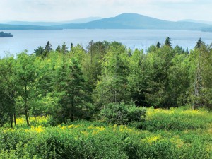
From the Rangeley Scenic Overlook there is a swift plunge to the eastern flank of Bald Mountain, which crowds the western shore of Rangeley Lake. Oquossoc is at the northwest corner of Rangeley Lake and can be a good pit stop for food and fuel. A side trip west on ME 4 to Haines Landing gives some nice views at lake level of Mooselookmeguntic Lake. Wikipedia says that Mooselookmeguntic is the Abenaki tribes’ name for “moose feeding place.” From Oquossoc the scenic ride continues east on ME 4 and 16 to the town of Rangeley. About two miles east of Oquossoc, I often divert onto the Mingo Loop Road which keeps you closer to the lake.
The town of Rangeley is my usual lunch stop, with a quick check on the progress of the Boston Red Sox or New England Patriots at Sarge’s Sports Pub & Grub while eating. There are several other restaurants in town, and don’t forget gas before you leave. Your greatest opportunities for lodging are in the town of Rangeley.
Route 4 continues the journey southeast along Rangeley Lake. There is a newly constructed overlook just south of town on ME 4 for some more magnificent views of Rangeley Lake and its mountainous accent. Also south of the town of Rangeley you may want to take Dallas Hill
Road east to the access road to the Saddleback Mountain Ski Area for some more views of Rangeley Lake and its splendid mountain surround. At the southeast corner of the lake, past Greenvale Cove, perhaps you might ride east for a ways on South Shore Drive to Rangeley Lake State Park where there is swimming, picnicking and camping for a limited season.
Past Rangeley Lake, ME 4 starts dropping quickly along Long Pond Stream, Long Pond, the Sandy River Ponds and Sandy River. There is a bank of flashing yellow warning lights, with a sign reminding you that you are riding through the realm of Bullwinkle Moose, and common sense should kick in to not ride this stretch of road at night. About two miles after crossing the Appalachian Trail again, you reach Small Falls. The river drops through four narrow falls cut through hard rock, worth a stop.
Next up on our ride of the return leg to Rumford and Mexico is ME 142, which is reached approximately 21 miles from the town of Rangeley. Having missed this turnoff to the south myself a few times, don’t be embarrassed if you need to double back from the town of Phillips. Route 142 is much narrower than ME 17 or 4, and that is not bad. Your sightlines are diminished in places, and remember that you are still making a general descent from the mountains of the Rangeley Lakes region—careful with that throttle.
From the turnoff from ME 4 to Dixfield along ME 142, you pass through the village of Weld, with Webb Lake directly to the west, and Mount Blue State Park to the east. This is a very pretty area. There is camping, picnicking and swimming in an offshoot of Mt. Blue State Park on the western side of Webb Lake, but with a limited season.
Too soon you ride down to Dixfield on ME 142, where you have a couple of options back west to Rumford and Mexico. You may ride on U.S. 2 west, or cross the Androscoggin River and ride ME 108 west. Both have heavier traffic than you have seen for several hours, but either closes this Rangeley Lakes region hundred-mile loop, with ME 108 a little more scenic.


