story and photography by Bruce and Sharon Hansen
[Oregon Motorcycle Roads: The Elkhorn and Blue Mountain Scenic Byways was originally published as a Favorite Ride in the December 2008 issue of Rider magazine]Why go? The story of a virgin landscape, raped by a hotel-sized dredge, a vast fire-ravaged forest, a paved road teetering at a whopping 7,392 feet and vibrant gold-hungry towns abandoned to fickle ghost-seeking tourists might keep you away.
This story is about a part of Oregon of which few natives have ever seen or heard. This piece of Oregon once throbbed with the fast-living people lured by the dream of a rich gold strike. Now the lonely roads seem to wait for something to happen again.
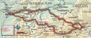
Sharon and I decided to ride two secluded Oregon Scenic Byways we had never explored: the Elkhorn and Blue Mountain. We wanted to pause in Sumpter near the historic dredge and do the evening creek-walk. We wanted to watch the swallows dip and wheel as they perform their evening feeding air-dance before settling in the eaves of the dredge.
We started out in early July toward Mount Hood, the stunning sentinel of Portland, Oregon. To us, and thousands of other ordinary suburbanites, this pleasant part of the trip meant an escape from the congestion of Portland and a dip of the toe into the lifeblood of rural Oregon.
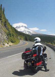
The sky a perfect blue, the roads clean and empty, our trip truly felt like it started when we turned off the much traveled Highway 26 to the rarely used State Highway 226 toward Maupin. The mountains near Maupin are so smooth and steeply rounded, most folks call them hills. Nice motorcycling country.
About this time we began to experience that childlike anticipation people feel when they are on the way to a top destination. Are we there yet? We love riding the serpentine asphalt that winds through the John Day River watershed. The views, light traffic and revealed apex turns makes this a world-class riding venue. The pullouts often highlight geological wonders and fossils digs, and are well worth the stop.
We spent our first night in Fossil. Here’s our advice: avoid the Shamrock. It was the worst food we’ve ever had while touring Oregon. Otherwise, the little town is friendly and nice for evening strolls. Walk up to the high school, pay a small fee, and leave with pockets stuffed with fossils.
From Fossil, we followed the continuing golden hills/steep basalt cliff/perfect pavement roads through Spray and Kimberly and had lunch in Dayville. We loved the food at the Dayville Café. Next stop: Sumpter for a two-day stay.
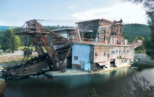
Understanding how a dredge works did not prepare us for the destruction this type of mining imposes on the land. Instead of a pristine wilderness, a visitor rides past thousands of acres of devastated valleys. The dredge pulls up the soil, extracts the gold, deposits the silt in the stream and then drops the cobbles out behind. From 1912 until 1934, various dredges were built to extract the gold from the Elkhorn Mountains. They ran until the mid 1950s. The last dredge, the Sumpter Dredge, offers visitors evening swallow-dance viewing.
Sumpter makes a great stop for riders because of the two restaurants, nice strolling, nearby hikes and the dredge. From Sumpter you can take the Elkhorn Byway to Granite, Anthony Lakes, Haines and Baker City.
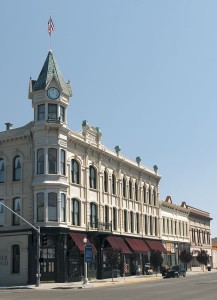
Granite embodies the character of an isolated settlement. A former mining boomtown, then a ghost town, it now has a population of 24 and its own mayor. It also has food, gas and lodging. What else do you want?
The road between Granite and Anthony Lakes takes you to the second highest paved Oregon road (Crater Lake holds the record). The roads in this area have good pavement with just occasional gravel near cliff faces. The forest becomes ever thicker as you gain altitude until you get to the burn near the top.
Most people hate burn views, but for me, it was relaxing. Earlier, I kept expecting a deer to leap out while leaning through the thickly forested areas. Having the ability to look through the naked forest for deer, turns and traffic made me smile.
Here’s some advice about Anthony Lakes: bring a picnic—there’s no other food nearby. The pretty alpine lake rests among grand peaks and begs for a stop. Water, picnic tables and pit toilets are placed just right to make the stop refreshing.
During the snowy season, this area attracts skiers to the winter-only resort. Perhaps as a result of all this winter traffic, the pavement east of Anthony Lakes resort looks like it has potholes and gravel patches imported from Iraq. Here’s some advice: go slow.
We arrived in Haines on July 4. Since the area around this flat, valley farmland is so well irrigated, it serves as nearly the only place in several counties where it’s safe to send up fireworks. Back in Dayville, we heard cowboys (real cowboys, not posers) talking about asking their girls to put on pretty dresses to go to the Haines fireworks and dance.
My pretty girl had on her Tourmaster motorcycle jacket and looked darn cute to me. We ate a barbecue pork lunch in the town park, right next to the tractor judging and the children’s rooster crowing contest. It’s hard to describe how strangers like us fit in just fine with the rural people who had traveled in their freshly polished pickups to the Haines barbecue. We just all belonged.
Not wanting to ride these roads in the evenings with all those roaming nocturnal deer, we decided to skip the fireworks and dance. We stopped in Baker to enjoy the 19th-century architecture and visit the Oregon Trail Interpretive Center—a must-visit place for the air conditioning, clean bathrooms and the moving display of life along the Oregon Trail.
In Sumpter, most riders stay at the Depot Inn (541-894-2522) and walk over to Borello’s for Italian food, or across the street for pub food at the Elkhorn Saloon. After dinner that night and free of motorcycle gear, we snuggled on a bench near the huge Sumpter Dredge and watched the birds dance and wheel.
We were planning on taking the Blue Mountain Oregon Scenic Byway (BMOSB) north toward home the next day. After all the fabulous riding we had done so far, we didn’t know that wonders awaited us. The next day the BMOSB would take us through a once-busy mining area, The Elkhorn Mountains, the Blue Mountains, and over a vast ancient lake basin which—according to Indian legend—was emptied by an enormous earthquake. At a rest stop, the ticking of the cooling bike engine would be the only barrier between us and the ghostly sighs of the standing skeletons where the forest had once lived. We would stop on desolate rural highways to let the cattle cross and rest in friendly green small-town parks on our way to Interstate 84.
Our last night on the trip, we put our phones and Blueant communication systems on charge in our I-84 motel and planned to take the trip again. The next time we would start with the BMOSB and reverse our route so we could enjoy the lost roads of Oregon all over again.


