story and photography by Kenneth W. Dahse
[Motorcycle Touring Northern New Jersey’s Skylands was originally published as a Favorite Ride in the July 2008 issue of Rider magazine]Unfortunately, many riders have an image of New Jersey inspired by Joe Piscopo’s famous lines from a Saturday Night Live bit: “I’m from Joisey, you from Joisey? What exit?” And The Sopranos didn’t help with its scenes of oil refineries, a truck-clogged turnpike and urban decay.
In reality, northern New Jersey’s Skylands has some of the best roads in the northeast, and is a rider’s dream with roads snaking through parkland forests, farmland and small towns.
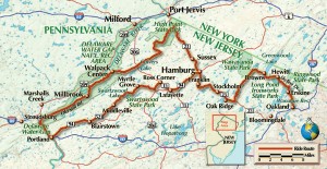
Beginning my Skylands tour in Oakland at the bottom of Skyline Drive, my Kawasaki Nomad climbed into the Ramapo Mountains with aplomb. At mile marker 2.4, right after the hidden driveway sign, there’s an Oakland Compost Facility parking lot on the right. A short hike on the hidden driveway leads to the Ramapo Fire Tower with its panoramic view west of the Skylands and east to the New York City skyline. Weaving down Skyline Drive also provides a bird’s-eye view of the mountains rolling endlessly westward like humongous ocean waves.
At the end of the drive I turned right onto Route 511, cruising along the shores of the Wanaque and Monksville Reservoirs which sparkled in the sun like diamond necklaces. The 560-acre Monksville Reservoir area has hiking trails, boat rentals and fishing opportunities. In West Milford, I traveled north on 513 to the Warwick Turnpike, my Nomad throbbing deeply as it climbed into Hewitt State Forest. Passing Upper Greenwood Lake, I turned left on Clinton Road. This wilderness route weaves through 35,000 acres of the Newark watershed, skirting the glittering reservoir.
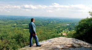
Be on guard here for deer and other critters. I once had to dodge a flock of wild turkeys thundering out of the brush like attacking fighter planes, and deer, bears and coyotes are abundant here and throughout the route. Clinton Road ends at Route 23. The ride north on 23 is decent but there are few congested areas.
At Hamburg, I turned left on Route 94 and then right onto Route 661 (Beaver Run Road). Route 661 serpentines swiftly over surging farmland, passing country estates on its rollicking way to Route 15 north. At the ‘50s-styled Chatterbox Restaurant, I turned left onto Route 206 until reaching Route 626, where I visited the 200-acre 4 Winds Horse Ranch. Here you can trade your iron steed for a flesh-and-blood one. Trail rides are $40 an hour; rides up to four hours are available. After leaving the ranch, I continued on 661 to Route 521 south, which snakes through the rolling green landscape.
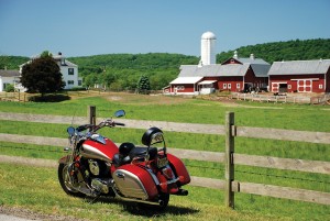
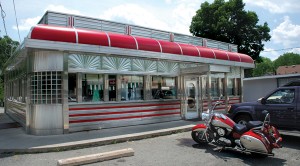
At White Lake Resource Area, there’s an 1812 farmstead and pond. From here Route 521 zigzags along the shores of Swartswood Lake. The northeast end hosts a state park with a beach, picnic area, boat rentals and a campground. On the west shore sits the Boathouse Restaurant with lakeside dining. I, however, had lunch at the Blairstown Diner–simple decor, delicious food and one of several locations in Blairstown used for the classic horror film Friday the 13th. Main Street features turn-of the-century architecture, and the impressive First Presbyterian Church.
From Blairstown, I roared south on Route 94 to Route 80 West, exiting at the Delaware Water Gap National Recreation Area. This 70,000-acre park has 200 miles of roads for riders to explore, although some are in poor condition. Old Mill Road, which parallels the river, was originally built in 1650 and is the main entrance into the park. Just north of the entrance is Worthington State Forest campground. Camping in the Gap or staying at a nearby motel also gives you the opportunity to canoe or kayak the river, an experience I highly recommend.
Millbrook Village, an interesting stop, is a recreated 19th-century rural community with the actual buildings from that era resettled at this location. At the Flat Brook intersection, I took Route 615 north, passing the Walpack Inn, a rustic restaurant with a huge stone fireplace, delicious food and a glass-enclosed dining area with views of deer feeding in an open field and mountains rising in the background. Just beyond is Walpack Center, a modern-day ghost town; its inhabitants were forced out of their homes by the U.S. government, which planned to dam the river and drown this unique area under a massive lake. Fortunately for riders and other outdoor enthusiasts, sustained citizen opposition killed the project, but not before most of the inhabitants had vacated their land. Today, abandoned homesteads can be seen throughout the park.
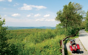
Cruising through the deserted village, I crossed the Flat Brook and headed into the primeval Stokes State Forest. My Nomad handled this challenging road with ease. Connecting with Route 209, I traveled south to the Sunrise Mountain Entrance. The road slowly climbs up the ridge of Kittatinny Mountains, offering views west into Pennsylvania and, at the Sunrise Mountain, east to the farms and mountains of the Skylands. At the overlook, I watched as hawks surfed through the blue heavens while riding waves of wind.
Stokes State Forest ends at Route 650. Cruising into High Point State Park, I followed the road signs to the monument proper, which unfortunately was still under repair. Nevertheless, the view from the base encompasses three states. On a clear day, you can see 60 miles away to the Catskill Mountains in New York and across all of New Jersey to Bear Mountain, New York.
I hated to leave this impressive site, but the day was growing late. As the sun slowly sank silently into the horizon, I reluctantly fired up the Nomad. Rumbling along enveloped in chilly darkness, I was comforted by thoughts of this beautiful ride, and I knew it wouldn’t be long before I once again rode the Skylands.
Additional Information:
4 Winds Horse Ranch, (973) 383-9144
The Boathouse Restaurant, (973) 300-0016
Blairstown Diner, (908) 362-6070
Delaware Water Gap National Recreation Area, (570) 828-2253
Worthington State Forest, (908) 841-9575
Walpack Inn, (973) 948-3890
Kittatinny Canoes, (800) FLOAT-KC


How long did this trip take?