Story and photography by David Owens
[South Carolina Motorcycle Rides: Touring Low Country was originally published as a Favorite Ride in the March 2007 issue of Rider magazine]
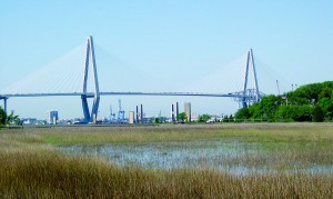
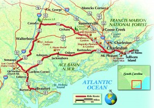
As the sun rises over the South Carolina coast, we are eager to hit the road. Our ride will take us past historic Low Country plantations, through rural old-growth forest, secluded marshes and small uniquely Southern towns. We take SC 703 from the Isle of Palms and soon cross Inlet Creek onto Sullivan’s Island, where our ride is framed by the Atlantic Ocean on our left and the tidal marsh on the right. As we cross the drawbridge into Mount Pleasant and make our way toward Charleston, we can already see the sweeping expanse of the Arthur Ravenel, Jr. Bridge, even though it is still several miles away.
With a main span of 1,546 feet the Ravenel—which opened in July 2005—is the longest cable-stayed bridge that carries a roadway in North America and it dominates the Charleston skyline. We are soon at the foot of the bridge, rolling on the throttle as we begin the steep ascent across the Cooper River. As we reach the high point, we experience the pure joy that is riding. The view of Charleston harbor on the left is spectacular; to the far left we see the permanently moored aircraft carrier USS Yorktown in all its glory. The harbor bustles as container ships move into position near the massive cranes that will unload them. Bright sunlight glints off the water and the white support cables that climb high to the bridge’s two towers. Crossing this bridge riding a motorcycle is an exhilarating experience, one that cannot be duplicated in a car.

We soon descend the bridge into Charleston, and could easily devote several days to seeing the sites in the city, but for now we are just passing through. We take U.S. 17 S through the city, cross the Ashley River, and head west on SC 61. After a few busy miles, we enter a portion of this two-lane road that has been declared a scenic highway. The Spanish moss-draped live oaks on either side of the road form a canopy that alternates shade and sun as we ride. This stretch is popular with both local motorcyclists and those visiting the area, and we encounter several other bikes. We pass many notable sites including Magnolia Plantation, Middleton Place and Drayton Hall, the oldest preserved plantation house in America open to the public.
We continue on SC 61 as the land becomes more open and we get a glimpse of agricultural life in South Carolina. About 25 miles out of Charleston, we turn right onto Givhans Ferry Road and enter Givhans Ferry State Park. The rutted, sandy dirt road that leads to the park requires a light touch on a cruiser, but the park gives us a chance to relax and enjoy great views of the Edisto River, the longest free-flowing blackwater river on this continent.

Back on the road we take SC 61 about 15 more miles and turn left onto U.S. 15 toward Walterboro. We are deep in country- side that is home to many types of wildlife. Where there is wildlife there is road kill, and in this area, where there is road kill there are turkey buzzards and large crows. They are bold and unafraid of vehicles, often unwilling to leave their meals in the road until the last minute and then flying away in unpredictable directions, so we give them a wide berth. We also encounter bugs, lots of bugs. By the end of this section of the ride, we are decorated with a healthy layer of multicolored bug guts. Some of these bugs are impressive in size, too. If you’re a T-shirt-and-flip-flops type of rider, you’ll likely feel as if you’ve been pelted with golf balls after this stretch of road.
About 11 miles later we ride into Walterboro, a picturesque town with many restored homes, and leisurely cruise through the small historic downtown area. Although there are many good places to eat here we are eager to continue the ride, so we stock up on junk food and caffeine when we stop to gas up the bikes.

We leave town on U.S. 17 Alternate and enter the ACE Basin, which is formed by the meeting of the Ashepoo, Combahee and Edisto rivers. The basin encompasses more than 350,000 acres and includes vast expanses of marshes, streams, rivers and sea islands. It is also loaded with rural two-lane roads where you can ride for miles without seeing another vehicle. The ACE Basin includes some of the most beautiful countryside in the state, and we ride through miles of it after leaving Walterboro.
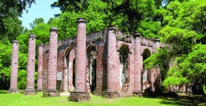
As we reach the small town of Yemassee, we turn left onto SC 68 and proceed a few miles until we turn left onto SC 21, Old Sheldon Church Road, where we are enveloped in thick woods. The cover overhead is so heavy that it feels like we have entered a cave, a feeling magnified by the sudden drop in temperature as the sun is obscured. Riding this secluded road is one of the highlights of our trip. The lack of vehicles, buildings and other signs of life make it easy to picture what this area looked like 200 years ago. After about 5 miles we reach Old Sheldon Church ruins. Originally built in 1755, the church was burned by the British during the Revolutionary War in 1779, rebuilt in 1826, and burned again during the Civil War in 1865.

After enjoying the solitude of the ruins, we mount up and continue down Old Sheldon Church Road until we reach U.S. 21 S/U.S. 17 N. The road soon splits and we remain on U.S. 21 S. We view great expanses of marshland on both sides of the road. The marshes are fragrant with the swampy smell of “pluff mud,” the sticky muck that lines them. After about 14 miles, we reach Beaufort (pronounced Bew-fort). This city is a true jewel, featuring an extensive historic district, plentiful waterfront views and many restored mansions. After we cruise down Bay Street and admire all the boats anchored on Beaufort Bay, we head out of town the same the same way we came in, going back up U.S. 21 N to U.S. 17 N.
We experience about 50 more miles of Low Country scenery on U.S. 17 N until we return to Charleston. As we enter the city, we have one last destination in mind. Since we skipped lunch, our stomachs are growling almost as loudly as the bikes and it’s time to eat. We take the Meeting Street exit and head into downtown Charleston to Jestine’s Kitchen for some authentic southern cuisine. After riding about 200 miles taking in the sites of the South Carolina Low Country, we’ll now explore the tastes—and we won’t forget to order extra collard greens and cornbread.


