story and photography by Sean Coker
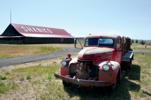
[Pacific Northwest Motorcycle Rides: Wasco County and beyond was originally published as a Favorite Ride in the April 2008 issue of Rider magazine]Don’t call it a ghost town. Shaniko, Oregon, has maintained a population of 30 people, but it’s a far cry from the turn-of-the-20th-century town that once billed itself as the “Wool capital of the World.” By 1911, a competing railroad line diverted much of the town’s wool traffic and Shaniko fell into disrepair. Then a flood in the mid-1960s destroyed most of the remaining town, but The Shaniko Hotel stands as an economic high-water mark, reminding passersby of a time when Shaniko rose out of sagebrush desert before returning to obscurity. Today our ride sets out to explore the obscurity of Wasco County and beyond.
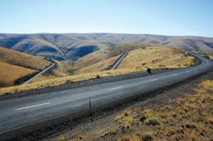
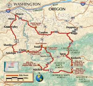
We leave Shaniko southbound on SR 218, passing a sunburned Chrysler peeling under an arid Oregon sun. The nine miles of road connecting Shaniko to Antelope were designed with motorcycling in mind. Riding downhill, we come across eight conjoined corners coiled like a fearless snake. A single, 90-degree radius turn would have sufficed, but the road’s engineers were obviously looking to challenge and tempt riders. We continue south until arriving in Antelope, where gas is available.

Continuing east on SR 218, we pass the Clarno Unit of the John Day Fossil Beds along quality road with little traffic. Few distractions allow riders to explore great lean angles and a landscape painted in the hues of wheat and juniper. SR 218 traces along the contours of a hillside, sweeping back and forth on the valley floor. After miles of mild turns have given us a false sense of confidence, we arrive at some corners worthy of the Nürburgring. Six neutral camber turns are placed along varying degrees of hills, in proximity to one another. Gravel is often found at the large, U-turn apex, as trucks run wide and kick rock onto the road.
Less than 10 miles later we arrive in Fossil, Oregon, and head south onto SR 19. The carcasses of mule deer are strewn alongside the road, serving as an omen to expect the unexpected. Passing over the John Day River, we junction south onto SR 207 toward Mitchell. SR 207 rises off the valley floor and we navigate chicanes mindful that only a tiny guardrail separates us from the cliff. Arriving onto U.S. 26 and we head west for five miles before heading north at Burnt Ranch Road, following signage toward the John Day Fossil Beds.

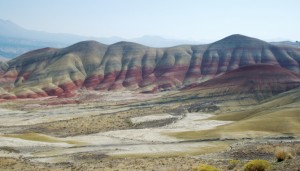
Six miles of road and one mile of traversable gravel later and we reach the Painted Hills National Monument. Surrounded by alkaline earth and sun-bleached plants, the paint of cranberry and pistachio colors in the hill seems odd. Signage explains the colors resulted from compressed volcanic soil that formed and eroded into this hill. Wildflowers bloom in late April-May, and there is no charge to visit the park. We ride back the way we came to U.S. 26 and east toward Mitchell.
In a town where hostel beds rent for $12 a night (including coffee and pastries) and the mayor waitresses at the Little Pine Café, one might not be too surprised to hear that the most famous resident in this 170-person town is a 300-pound black bear named Henry. Henry lives in a cage adjacent the gas pumps and is often found eating or sleeping. We continue east on U.S. 26 into the Ochoco Mountains before entering the John Day Fossil Beds-Sheep Rock Unit.
The canyon walls grow until they tower overhead, limiting light and visibility of the road ahead. At the junction with SR 19 we continue north, threading our way through the canyon along the banks of the John Day River. Reaching the junction with SR 207, we continue north onto SR 207 toward Ruggs.

Once in Ruggs, we carve westbound along SR 206 toward Condon. On the outskirts of Condon, golden grasses sway to soft breezes and it becomes easy to admire this sparse landscape. So open and inviting, nothing is hidden except for folds of earth. A hairpin turn allows riders to descend the hillside at speed and enjoy the sweepers resting at the foothills. We coast into Condon, where gas is available.
We leave Condon passing pastures and windmill farms on the western side of town. Outside of Condon, sweepers pave our way toward Wasco. Once in Wasco, we carve south onto U.S. 97 and back into Shaniko.

Eastern Oregon had a larger population 100 years ago than it does today. There used to be ranching, mills and mining industries, but today few options exist. Standing on Main Street, listening to tumbleweeds scratch across the road, it appears that not even ghosts haunt Shaniko anymore.


