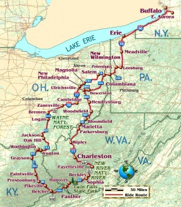
West Virginia’s the goal, and my college buddy Tim from southern Indiana calls to suggest we meet for the ride. It’s a great reason to include Ohio and Kentucky in the trip. On a sunny October afternoon, I leave East Aurora, New York, on Big Tree Road west toward Interstate 90. As I near Lake Erie, a strong wind blows behind a Canadian front that’s keeping all the temperate air in the southern states. I’m warm in my long underwear, electric vest and riding suit, but I’m glad to be heading south.
After l00 miles on I-90 west, I turn south on Interstate 79 at Erie, Pennsylvania. Sixty miles later, I exit the interstate for Pennsylvania Highway 208 through Leesburg and New Wilmington, Pennsylvania. A short jog over Route 158 to Pennsylvania 18 and four-lane Route 60 leads to Pennsylvania 108.
This is a pleasant, rolling two-lane highway that pops over a hill at the Ohio line. At Petersburg, Ohio 170 heads south to Ohio 14. It’s getting dark so I stop at the Dutch House Motel in Columbiana for the night. Many German, including Amish, pioneers moved here from Pennsylvania soon after the American War for Independence. There’s good, rolling farmland in east central Ohio and plenty of water.
The night-long rain has stopped after breakfast, and the road’s still wet as I head south on Ohio 164. The two-lane flows over open glacial hills and slides beneath fault-line cliffs where hardwoods hide narrow creeks. Occasional orange maples brighten the ride through farmland and hamlets. This Saturday morning I have the road mostly to myself.

Near Bowerston, I jog over Ohio 212 to Ohio 151 and U.S. 250 to Uhrichsville. Surrounded by healthy-looking farms, Uhrichsville has a railway museum and abandoned factories along Stillwater Creek. I backtrack through Dennison, a well-kept factory town to Highway 800. The ride south brings broken sky and warming temperatures. Crossing I-70, the road rises and turns through pretty farmland past hilltop cemeteries where Civil War veterans rest.
South of Woodsfield, Ohio 26 enters the Wayne National Forest (see Rider, November 1998). At Ohio 260, a sign warns the bridge is out at Rinard Mills, so I ride alone past narrow cornfields between close, round hills of the Wayne National Forest. Stopping at the bridge, the leaves are turning and it’s quiet. A rooster and four hens peck at the gravel as the engine cracks and pops its cooling-off noises.
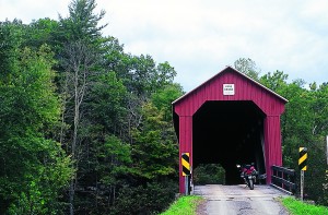
I climb the hilltops and S-curve down again to the Little Muskingum Valley at Bloomfield. A few miles south, a dirt road crosses a covered bridge. I ford a small creek to a national forest campsite where a four-wheeler enthusiast from Cleve-land is spending his annual trip with friends in the Wayne National Forest.
Leaving the national forest, Ohio 26 enters Marietta near the Interstate 77 bridge over the Ohio River. I meet my buddy Tim at Williamstown, West Virginia, and we make fast miles on I-77 south to Charleston, West Virginia. U.S. 60 east is four-lane for 12 miles, then wide two-lane for 32 more miles along the Kanawha River. Small villages and old factories squeeze between the river and mountain. After Gauley Bridge, U.S. 60 S-curves over Gauley Mountain to a low bridge across the Kanawha River. There, West Virginia 16 charges up the canyon as Laurel Creek tumbles down.
At Beckwith, we leave Laurel Creek and ride high to Fayetteville, where SUVs sport kayaks and mountain bikes. This is a center for exploring the New River Gorge, 900 feet down.

We spin back out of Fayetteville and cross the New River on U.S. 19. Completed in 1977, the New River Gorge Bridge is a National Monument and was the longest single arch bridge in the world until 2003. The Lupu bridge in Shanghai is now 105 feet longer. The National Park interpretation center on the east side of the gorge details bridge construction and local life before the span was completed. Sufficiently informed, we ride to the valley floor on the old road to the surface bridge and a view of the New River Bridge 876 feet above. Turning up the west side of the gorge, one may stand on the huge concrete bridge pier and examine its leg-size bolts.
Rejoining U.S. 19 above the gorge, we ride past Beckley, West Virginia, to Route 16 again toward Sophia. A few miles later, West Virginia 97 turns off. Highway 97’s fast sweepers and the afternoon sun remind us why the residents call this West “By-God” Virginia. At Hanover, U.S. 50 heads south, rising ever higher and more tightly squeezed between the stream and mountainside. Before Laeger, West Virginia, we mistake Panther Reservoir Road for West Virginia 80. A friendly resident directs us upstream along paved one-track over Panther Mountain Pass where we enter the Commonwealth of Virginia. We scoot and hoot through the tightest hollows, beneath blue sky, past small mines and coal conveyors.
Happening upon U.S. 460 north, we detour up narrow switchbacks to Breaks Interstate Park and pay a dollar to get in. Multiple pullouts overlook the Russell Fork River Gorge, 1,600 feet deep, and the high mountains of Kentucky. We zigzag off the mountain into the gorge where U.S. 460 takes us north to Pikeville, Kentucky, and a familiar chain motel as it gets dark.
Monday brings a clear morning as we head north toward Ohio on U.S. 23. After 40 miles, we turn onto Kentucky 201, called the Jenny Wiley Pioneer Byway. Kentucky 201 bops over small hills and cuts curves through quiet, gorgeous Kentucky farmland. The warm autumn air brings out the odors of the just-turning leaves and freshly cut corn and tobacco.
At Webbville, Kentucky 201 ends and Kentucky 1 continues north through more 18th-century settlements all the way to the Ohio River. At Worthington, we cross the river to Ironton, Ohio, into the southernmost part of the Wayne National Forest. Route 141 curves over wooded hills to Ohio 233 west where the forest gives way to open cornfields. At Oak Hill, we gas up the bikes, rehydrate and part ways, Tim returning to Indiana and I continuing north through Ohio.

Route 93 is a main highway in this part of Ohio, with the tractor trailers, busy towns and school buses to prove it. The farms and towns look well, but at Logan I detour to Ohio 664. Route 664 aims due north, but it rides the spine of a glacial esker and curves on its snake back, dipping now and again for 10 miles of great views. At Bremen, OH 664 is tabletop flat to U.S. 22. I ride fast northeast, enjoying the long views ahead with the sun behind me. At Zanesville, it’s mostly shade, but after 40 more miles on I-70 east and 40 miles north on I-77, it’s dark and almost freezing. I stop at New Philadelphia for the night.
Tuesday, I wake up to another bright blue morning eager for an early start. But it’s just 20 degrees so I dawdle over breakfast and dry the frost from my bike. By 9 a.m., it’s 32 degrees again so I ride north on Ohio 800 through dappled sun beside tall maples. Here, Route 800 follows one of Ohio’s many canals built in the early 1800s to move farm produce to market. At Ohio 183, I turn east, still following the Sandy & Beaver Canal, and enter Magnolia, Ohio, home of Magnolia Mill Extra Kiln-dried Cornmeal.
I leave peaceful OH 183 at U.S. 30 east and ride OH 9 north to Salem. Like dozens of small Ohio cities, Salem has a developed downtown of substantial commercial buildings, surrounded by small factories and tidy neighborhoods. Unfortunately, most of the factories appear closed. I retrace Ohio 14 east to Ohio 170 so I can roll again over PA 108. At PA 551, I head north on more rolling two-lane, ducking under the super highway at Pulaski to Mercer, Pennsylvania, and I-79 north to I-90 east.
At State Line, Pennsylvania, I’m drawn back to the two-lane along Lake Erie for the slow ride home. Not wanting the trip to end, I cruise through the sweet smell of concord vineyards, drinking in each view of the deep blue lake. I know it will be months before my next long ride. Near the closed, behemoth Bethlehem Steel plant south of Buffalo, I turn east onto Big Tree Road, put the setting sun over Lake Erie behind me, and I head for home.
(This Favorite Ride was published in the January 2005 issue of Rider magazine.)


