Motorcycling along the Continental Divide through Colorado and New Mexico.

For years I longed to ride the Continental Divide but had put it off because of the logistics of getting there and back. The Continental Divide runs from Canada to Mexico and divides the U.S. river drainage into east and west, and riding it is the dream of many an adventure motorcyclist.
The route was first blazed by mountain bikers and detailed in 2000 in “Cycling the Great Divide” by Michael McCoy. The book contains maps and a description of the route, mile by mile, from Canada to Mexico.
After reading Continental Divide Route (CDR) reports on the ADVRider.com forum, I decided I could easily ride the Colorado and New Mexico portions. I downloaded GPS files, entered them in my GPS, enlisted the company of my international riding buddy, Chuck Henderson, and set about finding the perfect motorcycle for the ride. I finally settled on the 2004 Suzuki DL650 V-Strom that was already in my garage, and Chuck rode his DR650, a single-cylinder, air-cooled Suzuki.

I met Chuck in Aurora, Colorado, and on the 20th of July, we set off on our CDR adventure. Our first night was at a Forest Service campground in Wyoming not far from the Colorado border and the CDR.
Putting away tents wet from a brief rain during the night, the next morning we rode Wyoming State Route 70 south to County Road 710 and then County Road 129 into Colorado, which took us along the Little Snake River to Elk River Road. Next stop, one of the foremost ski areas in Colorado, Steamboat Springs. This route was an easier alternative to the original route.

After lunch in Steamboat Springs we continued on dirt to Lynx Pass, then descended to the Colorado River at State Bridge, noted for being a favorite launch site for kayakers and river rafters. We crossed over and made our way into Kremmling to accept an offer from Paul, a fellow adventure rider, to stay at his mountain cabin and enjoy a cold adult beverage. He had ridden the CDR before and would be our guide on his BMW R 1200 GS. Though every day on this ride was special, I think day one was my favorite.

From Paul’s cabin we rode over Ute Pass to Breckenridge, where we picked up smooth gravel on Boreas Pass, crossing the Divide again on an 1800s railway grade of the Denver and South Park Pacific Railroad. A brief section of U.S. Route 285 and Colorado State Route 9 again found us on graded dirt from Hartsel to Salida, where we picked up food for our evening meal before heading south on U.S. 285 through Poncha Springs to the turnoff for Marshall Pass. Marshall Pass follows the route of the Denver Rio Grande Railroad, another 1800s line and competitor of the D&SPP railroad.
We camped near the summit of Marshall Pass, which is on the Continental Divide, sharing a meadow with some hikers who were traveling from Denver to Durango via the Colorado Trail. The next morning we rode down to Sargents on U.S. Route 50, seeking food and coffee at the café there. From Sargents we went west on U.S. 50 to the settlement of Doyleville and south on County Road 45 to Cochetopa Pass, a good graded dirt road.

We followed the route of an Otto Mears stage road, once again crossing the Divide, before turning south to Carnero Pass on County Road 41G. Otto Mears was well known for developing stage routes in the southwestern part of Colorado, including part of what would one day become the Million Dollar Highway (U.S. Route 550). From La Garita we went south again on County Road 38A into Del Norte, where we camped on the banks of the Rio Grande River at the Woods & River RV Park.
In the morning we rode south from Del Norte on County Road 14 after a great breakfast at Boogies Restaurant, crossing several passes and skirting the Summitville Mine Superfund Site before lunch in Platoro, an oasis in the mountains of Southern Colorado. There is gas and food available there, not much else.
After a good sandwich at the Gold Pan RV Park General Store, we headed for the campground at Hopewell Lake, New Mexico. We decided to forgo a rough section and took Colorado/New Mexico State Route 17 and U.S. Route 64 from Platoro to our campsite.
The next day was our Big Adventure: shortly after leaving Hopewell Lake, I misread my GPS and led us down a road that got progressively worse, finally turning into single track trail over some pretty rough ground.
We kept going because the GPS showed it to be Forest Road 45B that would eventually come out on Highway 111 at Vallecitos. Plus, we did not want to go back up what we had just come down!
But all’s well that ends well and we were finally off the mountain and on our way to Abiquiu via County Road 247 and State Route 554, a paved road we picked up at El Rito. Paul left us at Abiquiu after finding a hole in his swingarm boot. Chuck and I decided to slab it to Grants and a hotel for the night since we lost a lot of time on our “adventure.”

The next day we headed for Pie Town via State Route 117 and the last leg of our journey. We stopped off at El Malpais National Monument, then went on to Pie Town and the Pie-O-Neer for…pie, what else? Afterward we detoured by the Very Large Array, the largest radio telescope in the U.S., before we took State Route 59 to the Beaverhead Ranger Station where we camped and picked up the last of the dirt on our ride.

The final day of our CDR we made our way down Black Canyon on State Route 61 to the Mimbres Valley, riding into Silver City for a celebratory breakfast and to put another adventure notch on our bikes before heading for home. Two states down, three to go!
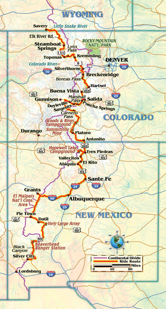



There is a error on the map: we didn’t take the US 60, I 25 and I 40 route from Abique to Grants but rather a series of secondary roads that let us avoid all but a couple miles of I 40 outside Grants.
Hi, not sure if anyone is monitoring this post but I am in Canada a looking at riding the cdr from Canada the the Mexican border. I’m looking for some gps maps of the route where to camp and gas stops along the way.
Check out GPSKevin Adventure Rides. I just ordered a set of maps from them and they look fantastic.