Adventures are good.
They don’t have to be big adventures, like crossing the Sahara Desert or Panama’s Darien Gap, but can be quite small and equally pleasurable. Like California’s Lost Coast.
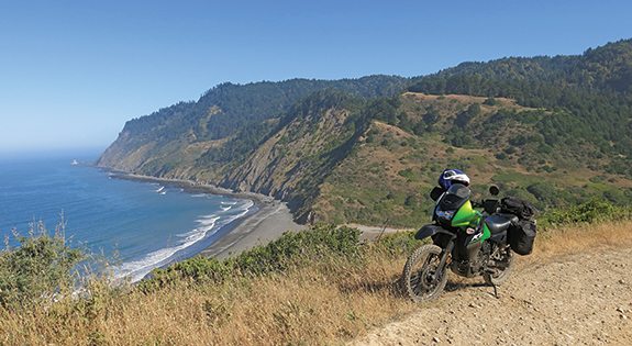
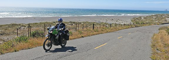
I am especially fond of Usal Road through the Sinkyone Wilderness, 25 miles of steep, twisty, bumpy, sandy, rocky and rain-rutted dirt road. First and second gear the whole way. A beautiful ride. At least for those who like such shenanigans, and I fully appreciate that we rough-roaders are in a small minority—although we do seem to be increasing in numbers.
This little trip was on the latest Kawasaki KLR650, called the New Edition, which is different from the old edition by virtue of stiffer suspension and a wider, more supportive seat—minor modifications I soon became totally in favor of. I rode the original back in 1985, when it was a mere 600cc and the first of the big dual-purpose singles to have an electric starter. It was an impressive machine then, and remains so today.
When we talk about dual-purpose, the duality is that they are fun on the pavement, and fun on a dirt road. For myself, I like the big singles when it comes to bad (i.e. entertaining to ride) roads. I find that some of the big ADV bikes weigh a bit much, like 600 pounds, when being wrestled around a steep, sandy hairpin turn at about three mph, slipping the clutch and keeping feet securely on the pegs. With six gallons in the big tank, the KLR pushes the scale to 432 pounds.
The KLR650 provides great sport on paved two- or one-lane backroads, good fun on the dirt roads, and is adequate on the highways. It will happily do 75 mph all day, which is about 5,000 rpm—only two-thirds of the rev limit. I do not like trucking a bike to where I want to ride, so I want an all-rounder. And the rated 37 horsepower is quite adequate for my dual-purpose purposes.
A little-known part of California is the infamous Lost Coast, which stretches some hundred miles between Fort Bragg and Eureka, to name the two large coastal towns that bracket it. The really lost part is the southern half, much of which has been declared a wilderness area. A hundred years ago, most of the transportation along this coast was via sailing ships, but also the occasional wagon, which needed a road. So the enterprising pioneers built such a road along the ridges above the mountainous coast.
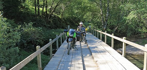
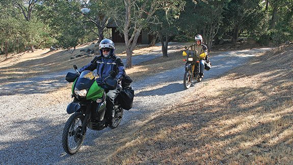
Since it is not really wise to go adventuring alone, I asked my friend Kurt to come along on his KLR650—1991 version. We rolled out early one morning, planning on getting near to the Lost Coast in one day, which meant 300 miles of major road. Highway cruising not being high on the entertainment level, we did exit every so often to find rustic parallel roads; all that takes is good map-reading skills. At Cloverdale, we angled northwest on State Route 128 into the heart of Mendocino County, which put us in Fort Bragg for the night.
Finding the southern end of Usal Road can be a challenge. Go north from Fort Bragg on California Highway 1, and after about 25 miles it leaves the coast, crosses a low range of hills, and comes into a narrow valley. There a bridge goes over the Cottoneva Creek, marked by a 90.6 mileage sign (CA 1 miles in Mendocino) stenciled on the side. About a quarter mile ahead is Usal Road (officially Mendocino County Road 431, though some souvenir hunter seems to have stolen the sign) with a very short bit of pavement going off to the left.
Several large warnings told us that this is a bad road, even worse six miles on, after the Usal Bay campground. We dropped tire pressures. I run low 30s on the pavement, low 20s on hard dirt roads; a bit less when it is soft sand. The KLR’s rear shock adjustment for preload is hidden behind the little black evaporative emissions canister, but that is easily moved aside—though you would have thought Kawasaki could have positioned it more discreetly.
A rocky dirt road took us up on a ridge and we could see the ocean again, and then through heavy woods until there was a long gray beach way, way down below. We got down to the beach, looked around, ate our snack bars and got ready for the next 19 miles.
To make the rough road even rougher to navigate, the coast-redwood forest was so thick that it blacked out about 85 percent of the road—it was so dark that I could see my headlight on a bright, sunny day. While the brilliant sunshine in the other 15 percent made it very difficult to see the rain-ruts, which could be a foot deep as they zigzagged across the road. A lot of us enjoy such challenges. Since this is now a wilderness area, maintenance seems to consist of clearing fallen trees, and that is it. I never got into third gear.
After those 19 delightfully arduous miles we arrived at a paved intersection, with Briceland Road coming in from the east and a relatively good dirt road running down the west slope to Needle Rock on the ocean. From there, the seriously hearty folk can hike the 22-mile Lost Coast Trail back to Usal Beach. No thanks.
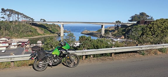
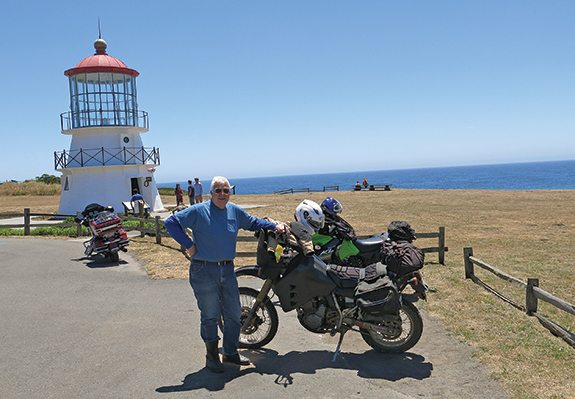
Returning to the intersection, Kurt and I headed north along Chemise Mountain Road, partly paved, partly gravel, to Shelter Cove, the original settlement in the 1850s—now with an airstrip and pricey houses all around. A paved road does run east 35 miles from Shelter Cove to meet up with U.S. Route 101 at Garberville. After a sandwich by the sea, we rode inland a couple of miles to pick up another dirt road going over the King Range—the Kings Peak Road. A lot of ups and downs and scrabbly hairpins, but this was not nearly as gnarly as the Usal Road.
We came out at Honeydew, the commercial center for the northern half of the Lost Coast, with a general store, post office and a two-pump gas station, diesel and low-test. There might be a whiff of cannabis smoke in the air, as the surrounding community of a few dozen houses is mainly in the business of agriculture. Now we were back on pavement, the Mattole Road. The Mattole River flows by here, wiggling west to Petrolia and Mattole Point, where there was once a major wharf.
Mattole Road got better and better, perfect for the KLR, essentially one lane climbing up to a ridge that overlooked the ocean, and six miles of shoreline riding without a building in sight. This is why the coast is called Lost. At Mendocino Point, the road went very steeply upward and inland, dropped down to Bear River, then sharply up again to Bear River Ridge. Stunning views! Though the wind might be blowing at 30 mph.
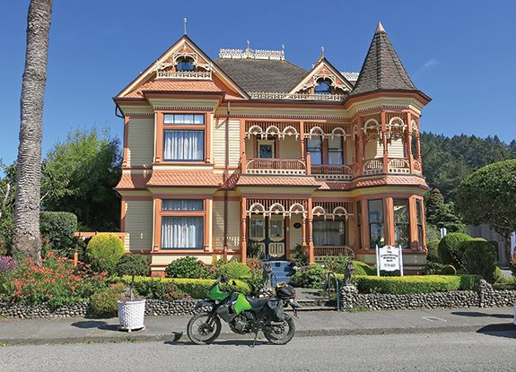
We descended to the Victorian town of Ferndale and headed into Eureka, seat of Humboldt County. Lots of motels and restaurants…and the famous Black Lightning Motorcycle Café on the corner of 5th Avenue (U.S. 101 north) and F Street. Kurt and I went there for breakfast, and half a dozen other traveling motorcyclists were already eating and drinking coffee. A dozen bikes are on display, helmets and jackets and other apparel is for sale, and there is great conversation.
After a satisfying Black Lightning egg and sausage sandwich, Kurt and I pointed the bikes east on State Route 299, into the Coast Range of mountains. Thirty miles along, we stopped at the Berry Summit vista area, a half-mile above the ocean. A hundred yards farther on, we turned south on narrow Titlow Hill Road, which soon became single-lane Forest Road 1 as it wound along for 50 miles through the Shasta-Trinity National Forest to meet up with State Route 36 at Mad River. This is all paved, and exactly the kind of road that the KLR is designed for—a bit on the rough side, lots of dirt off-shoots to explore, and in those 50 miles we saw one pickup and one car.
Our national forests are one of the great blessings of this great nation, with some 300,000 square miles of canopied splendor for us to play in. Some forest roads are closed to motorized traffic, which can irritate motorcyclists, but the forests have enough space to satisfy both riders and tree huggers. Most U.S. Forest Roads are dirt, but single-lane pavement is not uncommon.
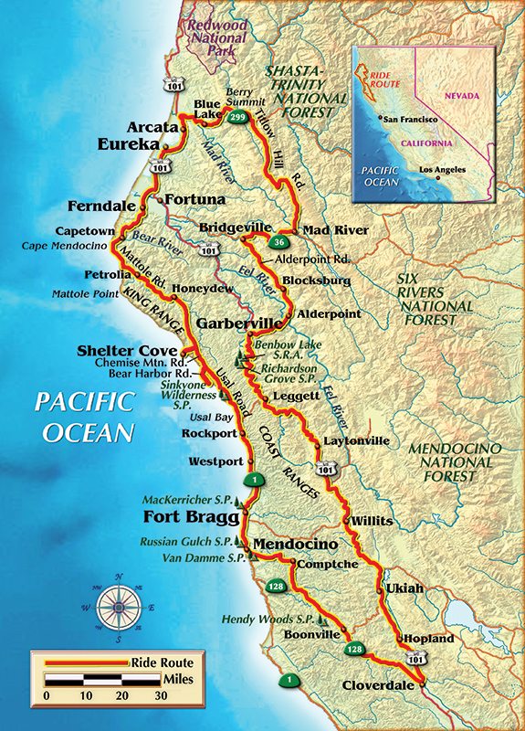
From Mad River we went west until we got to Alderpoint Road. This runs from Bridgeville on Route 36 over to Garberville on U.S. 101, and the town of Alderpoint actually was part of a railroad line a hundred years ago. Hard to believe that railroads were built in these mountainous areas, but that was how wood got down to San Francisco to rebuild the place after the quake of ’06—that is 1906, not 2006.
The road twists and turns, goes up and down, occasionally the thin asphalt has slipped away to leave a hard dirt surface. From Bridgeville (population 25) the road climbs 1,000 feet to Blocksburg (pop. 50), drops down to Alderpoint (pop. 200) on the Eel River, then climbs up to over 2,000 feet to cross Mail Ridge, and down again to Garberville (pop. 1,000) on the South Fork of the Eel River. Not many people live out this way, which means there is minimal traffic.
We could have spent another week roaming the back roads of the north woods, but with our cluttered lives ahead of us, Kurt and I had places to be, so we headed south and home.
My conclusion? The New Edition certainly provided a good ride for a great little adventure, and at $6,599 (2015) is quite affordable.
P.S.: While testing this 650 I have added another 2,500 miles to the odometer, for an average of 46.65 mpg. Giving me a 270-mile range, though I would recommend filling up at 250. I liked the Dunlop K750 semi-knobby tires, which did well on pavement and dirt, but had a pretty short life span…the ones on the test bike were pretty much done at 3,500 miles.
When I got home, I found a box with Kawasaki’s optional four-inch taller windshield, bolted it on, and found the bike was far more comfortable at freeway speeds. See your dealer.


 | Ep. 69 Rider Magazine Insider Podcast")


while reading your article on Dual-Sporting in Northern California on the Kawasaki KLR650 New Edition, much was said about the 19 miles of poor road conditions, a photo or two would have been nice to see what your riders consider “poor” road conditions.
How often did you need to add oil?
When you mentioned something about the price I wasn’t sure if you meant the new KLR was priced at $6995. Is this right?
Also, from my experience on the KLR, it’s a rather “top-heavy” bike, which means that when off-roading it’s tippy. And for the most part you need to keep it in first gear, which pushes it to overheating because it’s air-cooled. You can’t get the speeds up. But for logging roads and general touring it’s kick-ass.
Yes, the 2015 model base price is $6,599.
KLRMAN must nob much of a KLRMAN if he thinks the KLR is air cooled. Or I really messed up last year when I had to replace the seal in my KLR watter pump. I use my KLR to run errands in town, some of the stop lights here are so long they would make first gear dirt diding seem like a super highway, and my KLR stays cool in 100 degree days. The fan does cook my left thigh. Also with the suspention and torque of the KLR it is very seldom I am in first gear in the dirt.
Hi Clem
Just read your article again but with photos this time. Simply great!!
Say hello to our common friends……….Take care…Jewel