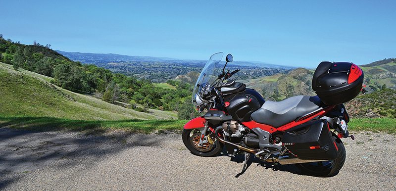
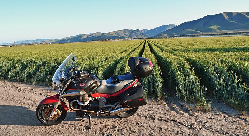
Today I’m riding the rural roads of Santa Barbara and San Luis Obispo, California, leaving mid-morning because I want to miss the deer-roaming hours on State Route 154 over San Marcos Pass, just north of Santa Barbara off U.S. Route 101.
Mid-week, Route 154 can be an enjoyable ride, with gentle curves near pleasant woods and pastoral scenery. After cresting San Marcos Pass, you’re treated to a wonderful view of Santa Ynez Valley. Once in the valley, 154 is straight and wide amidst pastures of idle horses. At the valley’s north end, Figueroa Mountain Road takes you up this 4,500-foot mountain. At the top there’s camping, picnicking or gazing. This road starts as a wide, paved two-lane weaving through cattle and horse ranches, then after about seven miles becomes narrow, poorly maintained and winding, demanding full attention. On the top beware of occasional high winds, but prepare for marvelous vistas of the surrounding valleys.
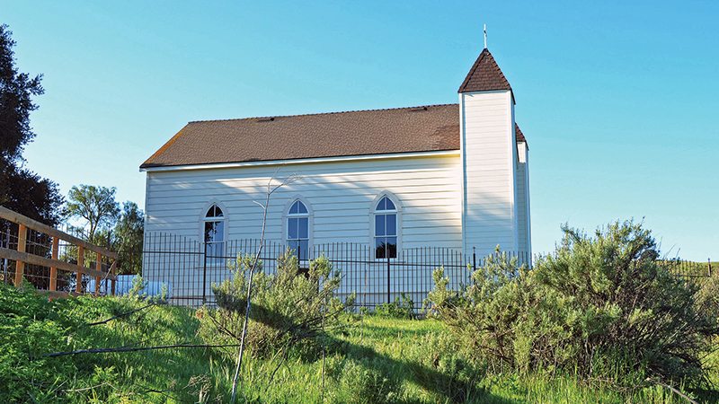
Descending back to Route 154 and heading north, I pick up Foxen Canyon Road, a gently winding two-lane road in a sedate area of farms, ranches and numerous wineries. Benjamin Foxen settled this area, receiving a Mexican government land grant in 1837. Since this is mid-spring, everything is green and there are numerous patches of lupines and bright poppies along the road. Close to Sisquoc, I come upon Santa Barbara County Historical Landmark No. 1, San Ramon Chapel, perched upon a bluff. In 1875, Frederick Wickenden bought redwood boards for the chapel, and Fred and Thomas Foxen built it with a local carpenter.
Farther along Foxen Canyon Road I turn onto Tepusquet Road, knowing I’m going to experience a motorcycle-riding gem. Jose Tomas Antonio settled this area, named after the Chumash Indian village Teqeqs, in 1837. I start out on great two-lane asphalt, weaving back and forth over the rolling grassy foothills of the San Rafael Mountains. After about 10 miles, in the shade of huge oaks, I reach the crest and head down on serious curves over great asphalt toward State Route 166 and dry Cuyama River. At Route 166, heading west takes me through more San Rafael Mountain foothills on a wide two-lane leaning through large sweeping curves. Approaching Nipomo, I’m passing endless grassy fields filled with red wing blackbirds—shades of Zen and the Art of Motorcycle Maintenance!
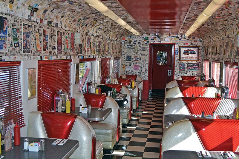
Just before reaching U.S. Route 101, a right turn puts me on Thompson Road toward the older part of Nipomo. Cruising northwest, the road changes into Los Berros Road. After U.S. 101, the gently curving road passes small farms, stands of trees and rural homes before reaching State Route 1 (Pacific Coast Highway). I’m taking a short northern detour on PCH to check out the monarch butterfly migration at the Monarch Butterfly Grove in Pismo Beach. These guys hang out here from November through February. Afterward, I wheel around and head south down PCH, away from the populated Pismo area through rural farming landscapes. At the Rock & Roll Diner in Oceano, housed in an old railroad dining car, I take a coffee break and enjoy this blast from the past.
Back on PCH, a little after passing Orcutt, it splits to the right, and I take State Route 135 east before turning north on Harris Grade Road, which provides some challenging and enjoyable curve carving. It passes over rugged foothill terrain of chaparral, oaks and scrub before depositing me back on PCH north of Lompoc.
Past Lompoc, still traveling PCH, I’m climbing the coastal Santa Ynez Mountains on a wide two-lane through beautiful green grassland dotted with oaks. About two miles from Lompoc, Jalama Road is 15 miles of curvy asphalt two-lane over lush green, rolling coastal foothills and through shady tree-lined canyons. The surface is occasionally rough and bumpy. Jalama dead-ends at the Pacific Ocean and Jalama Beach County Park. Chumash Indians once had a settlement here named Xalam. Now you can picnic, camp or stay in a cabin and enjoy a famous burger at Jalama Beach Grill.
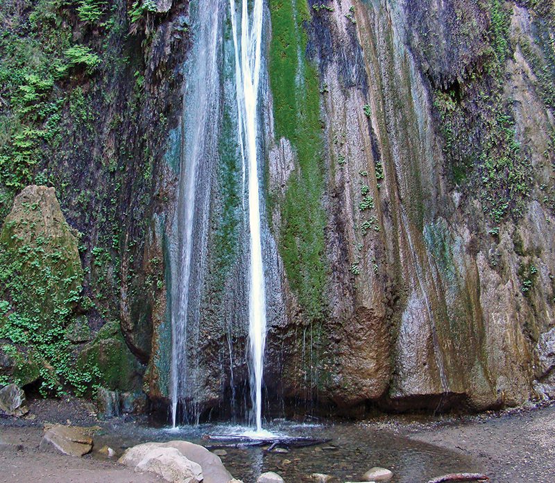
Backtracking to Route 1 and continuing south, at U.S. 101 I turn north, climbing Nojoqui Pass and looking for Alisal Road, which heads northeast and passes by lovely stands of large shady oaks. After a mile I reach Nojoqui Falls Park for a leisurely walk up the cool Nojoqui Creek to view the falls. After this, Alisal provides more gentle curves bordered by grand oaks before reaching Solvang.
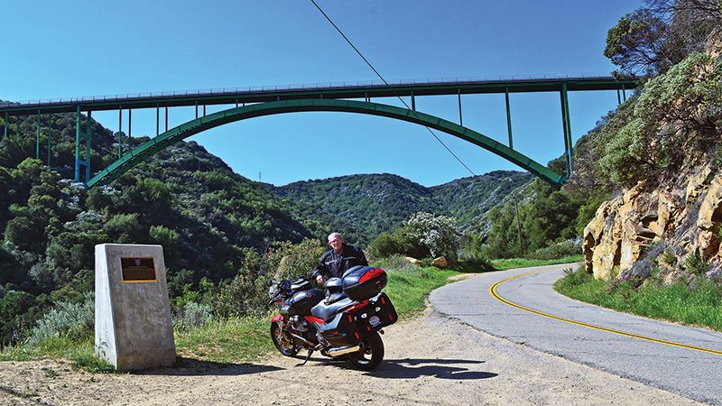
Here I catch State Route 246 east, then pick up State Route 154 south. This stretch is a replay but worth the treat at the end. About 14 miles south, it’s a left onto Paradise Road and a quick right onto Stagecoach Road to Cold Spring Canyon, just below the notable Cold Spring Canyon Arch Bridge. Motoring across it on Route 154 above, you can’t appreciate the graceful arch of this beautiful bridge. Completed in 1964, it was one of the longest steel arch bridges in the USA. It spans 700 feet across Cold Spring Canyon and is best viewed from Stagecoach Road 400 feet below.
After enjoying the spectacular span of this graceful arch, continuing on Stagecoach Road takes you to historic Cold Spring Tavern. This restaurant, built in the 1880s to serve travelers taking the newly completed San Marcos Pass toll road, still serves lunch and dinner.
This is the end of my relaxed ride through the rural side of Santa Barbara and San Luis Obispo counties. Besides enjoying a relaxing country pace, I savored several fantastic motorcycling roads well worth riding again.
(This article Green and Gold was published in the October 2014 issue of Rider magazine.)
 |
 |
 |


 | Ep. 69 Rider Magazine Insider Podcast")


I’ve got to add RT 58 between McKitrick, and San luis Obispo area….wow, living in Ohio, and having great roads close in WV, Va, NC, TN, and KY,the BRP, I would rate it right up there at the top !!!……
I did that road 2-weeks ago. Awesomeness. About 25 miles of fresh pavement between Taft and Lake Santa Mmargarita. We saw 3 cars all afternoon. did the Pozo loop in the early AM.
Loved the article. I live here on the Central Coast in Santa Maria. Just went north yesterday up Hwy. 1 to San Luis Obispo to burn up some gas so I could make a repair on my gas tank while it was empty. The route you took provides a great way to see so much of what is good about riding in this area. Thanks for the great ride.