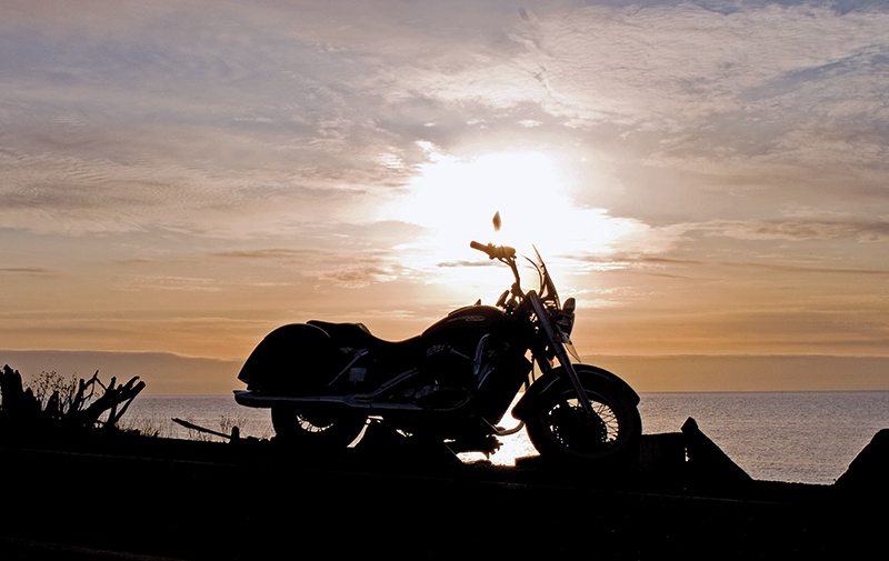
Riding a motorcycle in the Pacific Northwest is chock full of yin and yang. The sometimes long dreary winters feature predominantly gray skies and rain that lasts for weeks, but the summer months can be so crystal clear, with landscapes so spectacular, that it simply takes your breath away. At this time of the year, getting on the bike can be so intoxicating that you never want to get off, and in the long days of summer on this Cascade Loop near the Canadian border, you almost don’t have to.
The loop encompases Highways 2, 97 and 20, and offers the option of starting either on the coast or taking the mountain section first. I recommend the latter, as you will probably appreciate the more sedate coastline ride after a few days in the Cascade Mountain passes. From Seattle, taking Interstate 405 to Washington Route 522 northeast to Highway 2 at the town of Monroe gets you to the loop’s suggested starting point. Just south of Monroe, look for Ben Howard Road going east, a winding two-lane track that makes its way along the Snohomish River through Washington state farmland and ends at Mann Road. Make a left to the town of Sultan and Highway 2, but first stop at the bridge overlooking the river for a very fine view of the deep-blue winding river receding into a snowcapped Cascade Mountain perspective.
Highway 2 going east begins its gradual ascent at the aptly named town of Startup, gaining altitude as it runs into the mountains. For the 25 miles to Steven’s Pass, the highway continues along the Snohomish River through the Wenatchee National Forest, winding its way through the emerald green pine forest in sight of a river whose colors range from turquoise to cobalt blue, and with peaks of the slate-gray Cascade Mountains rising in the distance. Spectacular! Steven’s Pass, at 4,061 feet, is the highest point on Highway 2 and leads you through the heart of the Cascade Mountains. Once through the pass, the well-paved mountain highway offers mile after mile of excellent views, with surrounding mountains that peak at 6,000-7,000 feet. Mount Howard, at 7,063 feet, is the area’s highest.

The Cascade Mountains divide Washington into different topographical areas and weather regions. Seattle’s summer temperatures typically range from the high 70s to 80s, but as you ascend into the mountains, the temperature can drop as much as 30 degrees. Also, while summer in the Pacific Northwest brings weeks of dry weather, this area is known for rain, and the combination of the cool mountain elevations and wet weather can be a recipe for hypothermia. East of the mountains, the elevation drops to 800 feet above sea level and the area becomes high desert, where summertime temperatures can get quite hot. As such, you’ll want to pack both winter and summer riding gear, and have a rainsuit handy too.
The alpine-styled town of Leavenworth greets you as you ride out of the mountains, and then Cashmere, Peshastin and Sunnyslope follow until you reach U.S. Highway 97-Alternate and 97. Turning north, the two highways run parallel on either side of the Columbia River, where the yellows, browns and scrub greens of the desert topography contrast with the Columbia’s cool blue. The eastern side of the river also parallels a well-used railroad line, so you may get a friendly wave from a train conductor heading in the same direction. As you approach the Chelan and Okanogan area, the population increases, as does the availability of lodging. If your schedule permits, staying an extra day in the area allows time for some excellent local rides and outstanding sightseeing before taking up the ride again west on Highway 20.
State Route 153, which runs northwest beginning about 53 miles north of Chelan, “cuts the corner” and connects 97-Alternate to Highway 20, and can either be taken as a route option or a local ride. It’s an easy stretch of transitional desert-to-forest rural highway that runs through the Lake Chelan National Recreation Area. Another option for a spectacular day ride is State Route 155, also called Coulee Boulevard, north along Banks Lake to the Grand Coulee Dam. Taking Highway 2 east from the town of Orondo for 52 miles through some very sparsley populated area leads to State Route 155. On the way, make a short detour south on State Route 17 to see the visual treat of Dry Falls State Park, then return to ride north along Banks Lake to the town of Grand Coulee and the dam, one of the most ruggedly beautiful areas in north central Washington. Route 155 runs through yellow-brown desert surroundings with a contrasting cool blue lake (formed by the dam) on your left, along a craggy butte wall that later opens to Northrope Canyon on your right. The road passes through Steamboat Rock State Park, an outcropping of mountainous islands just south of the aptly named Electric City. Of course, a stop to see the Grand Coulee Dam is a must.
Beginning the return ride west, the best of the Cascade Loop is yet to come. Highway 20 runs through high desert to mountain forest through the Methow Valley along the river of the same name, and as the river goes, so does the road. East of Winthrop, the excellently paved highway shows off yellow-brown buttes and desert pine. At Mazama, the highway and river go their separate ways, and Highway 20 begins its ascent into the Cascades.
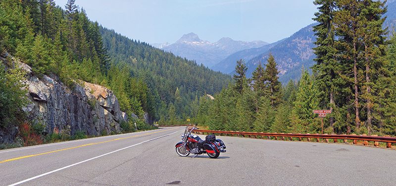
For the next 90 miles, settle in for mountain riding that has few equals in the continental U.S. Up in the rarified air near the tree line, the stunning jagged mountain peaks—some covered in snow well into the summer—are a staggering sight. The Washington DOT is also very accommodating of sightseers, and the highway has many roadside pullouts with some of the best mountain views. The stop to view Crater Peak is one of these.
Ross Lake Recreation Area is another one of the uncommonly beautiful places that seem to be commonplace in Washington’s Cascade Mountains. A stop here to view Diablo Lake reflecting the surrounding mountains is not to be missed. The deep green forested mountains shrouded in mist and reflected in the impossibly cyan blue lake is so amazing that the scene must be viewed for several minutes to fully appreciate that these colors truly exist in nature.
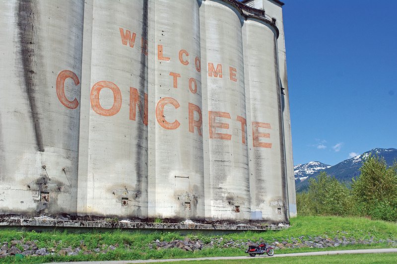
Farther west, the town of Concrete with its huge concrete silos prominently displaying the town’s name marks the western end of North Cascades National Park, but the ride is by no means over. For the next 30 miles, from Concrete to Interstate 5, Highway 20 becomes an unremarkable, commercialized highway, but of course, there is always a worthwhile detour. Just west of Concrete, making a left turn at Gordon Road and going a mile brings you to the bridge over the Skagit River, and a right turn immediately after the bridge brings you to the South Skagit Highway, which runs along the river and parallel to Highway 20. Settle in for a marvelous riverside ride, complete with overhanging trees and views of the winding river along its entire 24-mile length. The highway ends at State Route 9, and a right turn returns you to Highway 20 to begin the last leg of the Cascade Loop.
West of I-5, 12 miles of open farmland brings you to the start of Whidbey and Fidalgo Islands. In less than 200 miles, you have ridden from the high desert into primeval pine forest, past spectacular mountain peaks, alongside lakes and rivers and past rural farms before reaching Padilla Bay, which connects to Puget Sound and the Pacific Ocean.
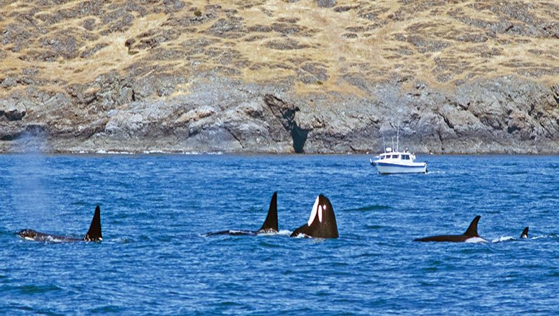
The seaside town of Anecortes occupies the northern end of Fidalgo Island, and after the 200-mile riding day, this is more than a good place to find a room for the night. A popular vacation spot, the town features chain and local hotels, as well as private condo rentals on the northern end of the island (make reservations in the summer!). Pedestrian friendly, you can park the bike and walk to the town’s many local restaurants, and Anecortes routinely sponsors classic car shows, concerts and other events to entertain summer visitors. Peaceful marinas circled by snowcapped mountains are filled with ocean-going vessels of all kinds, and whale-watching tour boats leave from Anecortes several times a day.
Highway 20 and State Route 525 are the main highways through the center of Fidalgo and Whidbey Islands, but again, taking the less-traveled route to explore the coastal areas and seaside towns of these islands will make the most out of a visit here. From Anecortes, a ride out to Washington Park on the northwest corner of Fidalgo Island, then going south on Marine Drive and Rosario Road, is the preferred route. Rosario Road rejoins Highway 20 just north of neighboring Whidbey Island, over a narrow waterway known as Deception Pass, and a stop to walk out on the 180-foot-high Deception Pass Bridge is another “must-do” on the Cascade Loop ride. Elevated above the winding narrow waterway, a crystal-clear summer’s day yields views of the forested islands inhabiting the green waters of Puget Sound, with the white peaks of the Cascade Mountains to the east and Olympic Mountains to the west. Once on Whidbey, take time to explore the West Beach Road/Joseph Whidbey State Park area, where the pristine coastline’s slate-gray sand and turquoise water are rimmed by the Olympic Mountains on the horizon. Then head across to the eastern side of the island for a ride on North Bluff and Saratoga Road with a stop at the town of Langley for a break. A short detour to the southern end of the island before taking the ferry back to the mainland completes a good day’s ride, and a fantastic tour.
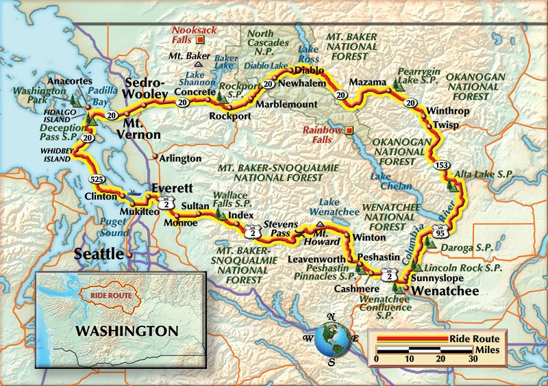
The 20-minute ferry ride from Clinton to Mulkiteo gives you a few minutes to relax, have a cup of coffee and reflect on the spectacular Cascade Loop. From Mulkiteo, it is a short ride back to the tour’s starting point at Monroe, or the city of Seattle. Virtually nowhere else in the continental U.S. does a 426-mile tour offer a rider the opportunity to experience four vastly different and stunningly beautiful topographies, as well as the opportunity to ride some of the best roads in the Pacific Northwest.
(This article The Cascade Loop was published in the January 2013 issue of Rider magazine.)


 | Ep. 69 Rider Magazine Insider Podcast")


Great article, but hardly a mention of the Bavarian village of Leavenworth or the western themed town of Winthrop. I have ridden the North Cascades Highway with my son it is truly a breathtaking area.
I think that the highway going north out of Wenatchee is US97,
not US95 as shown on this map.
The Index Art Festival will be held on Aug. 2, 2014. In the Cascade Loop publication it is listed as Aug. 3rd which is incorrect.
We hope all will join us but make sure it is on the 2nd. of Aug.
Judy, We’d love it if you added this event to our online Events Calendar. Please go here (http://ridermagazine.com/calendar/) and click on the red button in the upper right that says “Post Your Event.” Then you can type in the event details and we’ll get you added to our list. Thanks! Please let us know if you have any trouble.