The first music video ever played on MTV, at 12:01 a.m. on August 1, 1981, was for a song by the Buggles called “Video Killed the Radio Star.” Despite the dire prediction of an oddball British New Wave duo, radio stations and pop/country/rap/rock/etc. stars survived. Eight-track players went the way of the dodo bird, replaced by cassettes and then CDs, but radio has coexisted with music videos for three decades, and the reach of radio waves has expanded with the rise of the Internet (Pandora Internet Radio, which has 80 million users worldwide, was valued at $2.6 billion when it went public in 2010).
Similarly, the proliferation of portable GPS navigation systems hasn’t relegated maps to the dustbin of history. In fact, GPS (global positioning system) technology has allowed cartographers to create much more accurate and detailed maps. Having a GPS unit mounted on your motorcycle is undeniably convenient; as long as it has power and an unobstructed view of the sky, it can help you pinpoint where you are and how to get to your destination. But GPS units are expensive, and while they’re not prone to breaking, malfunctions can and do occur. And even if your GPS (or the mapping function on your smartphone) works fine, sometimes there’s just no substitute for an analog solution in this increasingly digital world.
As Clement Salvadori wrote in his June 2012 Road Tales column, “I’m in favor of the efficiency of GPS, but I don’t find it very useful when contemplating a trip. You need some imagination, which is helped along by any map. Or a small stack of maps, as the case may be.” You can’t spread out a GPS on your kitchen table and take in the entire region, absorbing the possibilities.

Not long ago, Butler Motorcycle Maps sent me a stack of maps, nestled securely in a Cordura pouch made by Wolfman. Included were all of the maps that Butler offered, covering most of the Western United States: Colorado, Idaho, Montana, Rocky Mountains, Southern California, Texas Hill Country, Utah and Wyoming, plus two Backcountry Discovery Route maps for Washington and Utah. Butler has since added a new map for the Ozarks in Arkansas. I’ve used the Southern California map extensively, and recently I used the Colorado and Utah state maps on a 1,300-mile trek from Las Vegas to Denver.

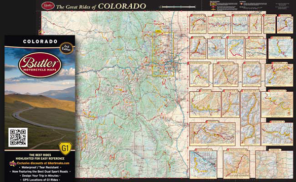
The Butler team consists of brothers Court and Fred Butler, plus Justin Bradshaw, Scott Calhoun and Bill Eakins, a group of motorcycle enthusiasts whose mission is to share the best roads with the riding community. They research and ride roads in each state or region, then put together detailed maps packed with useful information. Each Butler Motorcycle Map focuses on G1 roads, “gold standard” roads highlighted in yellow that are the best paved roads in the state or area. According to Butler, by “combining extremes such as rapid elevation change and proximity to cliffs and canyons, these thrilling rides possess an element of peril that demands attention. G1 road-rated routes are as dramatic and scenic as they come.” A single state highway can vary from G1 to somewhat less spectacular G2 or G3 ratings over several miles, drawing attention to its most impressive sections, and then as the highway straightens out or enters an urban area, it’s treated like any other road—passable, but nothing special from a motorcycling perspective.
On the main map, which illustrates terrain in full color, each G1 road is identified by a number and surrounded by a highlight box, indicating the area that is shown enlarged elsewhere on the map, with the addition of elevation contour lines. G1 roads are also identified by name and include detailed descriptions, elevation charts, GPS coordinates and informational symbols (e.g., seasonal closure, twisty road, river, caution wildlife and so on). On my most recent trip, I bagged 5 of the 21 G1 roads in Utah and 6 of the 24 G1 roads in Colorado, and all were amazing!

Each Butler Motorcycle Map also identifies and describes Paved Mountain Trails (“These narrow ribbons of asphalt have no center stripe, no shoulder, tight turns and steep grades. They are so unique you may wonder, why do these roads exist?”), Lost Highways (“Faded center lines, crumbling shoulders, and long lonely miles put these roads in a category of their own.”) and Recommended Dirt Roads, identified by name and grid location and chosen “for their unique beauty and ‘link-ability’ to our recommended paved roads.”
All Butler Motorcycle Maps are made of waterproof/tear-resistant material, fold to 4.25 x 9 inches and fit into most tankbags and map cases. They also include state/national park listings, a mileage chart and Mobile Tour Guides, which divide each state or area into regions and include QR codes that can be scanned by a smartphone to access videos, motorcycle gatherings, repair shops, road conditions, weather and places to eat, drink or sleep—or so it seems. When I scanned the QR codes I was either taken to the Butler website’s main page, or a useless Mobile Tour Guide page (e.g., when I scanned the QR code for Glenwood Springs, CO, I was taken to a map of Sydney, Australia!). Without a smartphone, you can access the Mobile Tour Guides on Butler’s website, but I found them to be of limited value. Though described as “Places You Don’t Want to Miss,” the recommended restaurants and hotels in my own backyard of Ventura, California, were nothing special, and no ratings or descriptions are provided, just names and locations. You’ll do better with Yelp or TripAdvisor.

As someone who enjoys poring over maps, letting my mind wander with the possibilities of open-ended, exploratory rides, the detailed, full-color Butler Motorcycle Maps are a goldmine. They provide much more detail and insight than traditional maps, though less than some motorcycle tour books or magazine articles. Using the maps together with narrative tour guides will provide the most well-rounded perspective on a particular area. Butler Motorcycle Maps are high-quality reference tools that I will keep in my tankbag as I explore new places and check off the list of G1 rides in California and beyond. They’ve turned me on to roads that I knew nothing about and delivered the goods.
Butler Motorcycle Maps are $14.95 each, and multiple map bundles are available at a discount.
FOR MORE INFORMATION:
Butler Maps, P.O. Box 4746, Eagle, Colorado 81631; (877) 379-6053; butlermaps.com


 | Ep. 69 Rider Magazine Insider Podcast")


When are they start looking at West Virginia? I’ve been riding here for 40 years, and still haven’t discovered all the great roads. Guess it’ll take them a while to get it done too.
Donald,
We have plans for east coast maps.
You assume everyone knows who “we”/you are. Maybe you should tell us that you work at Butler Maps?
We are working hard to completely revamp our Mobil Tour Guides.
How do Butler Maps differ significantly from Destination Maps from BC, Canada?
John,
Destination Highways (DH) maps are excellent maps. I’d use both.
They are also printed on tough plastic like Butler Maps.
I’m not sure of their material, but we spec the highest map-grade plastic available. National Geographic maps use the same grade.
We ride any and every single paved road in each state. It’s a very long process. We then break down each great road section with a patented 3 color-coded, 3 tier rating system. DH does rate roads with their TIRES system & Twisted-edge segments, which are a sole ratings for that section. We break it down farther and break those sections into 3 different color G ratings.
Our top road rating (best of the best) is G1 and we then go a step farther and provide an enlarged detail box of that section with GPS waypoints and all. We don’t want to just say, go down that road it’s good. We highlight where the best sections are within that road and differentiate the quality (G1, G2, G3). It’s very easy to read and see with the color coding system of where you should be riding.
We also label lost highway sections which are remote cruising style roads plus we label recommended dual-sport roads (easier to medium dirt) plus other key dirt roads that connected with our G roads. We have created a complete web of ADV routes to choose from. DH focuses solely on paved roads. We also have an ADV/dual-sport series of cross state Backcountry Discovery Route maps http://www.backcountrydiscoveryroutes.com/blog/
Our maps are designed for every and any type of motorcyclist….
…Our So Cal has an additional category of Paved Mountain Trails, which are often single lane paved & twisty unique roads to California. Nor Cal map will have these too.
Next we label commercial hot springs, parks, camping spots and other key motorcycle point of interests. We see our map as a complete tour guide not just a road locator.
Our Mobil Tour Guides are accessed by scanning a QR codes on your map with your smart phone and then your phone can guide you on the fly to lodging and food plus dealer lists, weather and more. DH does not use QR codes. You must bring along their book for these details. With online guides we can make up to date changes that a book could never offer. Our Mobil Tour Guides will also offer special deals that are available in that area and only available through us. We’ll be partnering with motorcycle-friendly business.
DH maps are $30 ea. Ours are $15. They are focused on their book primarily and their map secondarily….
…DH products are well researched and dynamite touring tools for sure.
We feel we have upped the bar and produce the best motorcycle-specific maps in the world. Please try a state and if you are not 100% satisfied, we’ll fully refund your purchase…we’ve never had one come back.
Thanks for asking John!
Bill Eakins
Any update on the east coast maps for Virginia West/Virginia/Maryland?