story and photography by Lance Oliver
[Midwest Motorcycle Rides: Ohio to West Virginia was published as a Favorite Ride in the September 2009 issue of Rider magazine]
Even when gasoline cost a fraction of today’s going rate, I always felt better about a ride to a destination than a ride for pure recreation. For the past seven years, I have lived in the small enclave of Bexley, Ohio, surrounded by the state’s capital, and my most common destination is 100 miles away, the hilltop parcel just across the Ohio River in West Virginia where I grew up scouting the woods, where I first twisted a motorcycle throttle (my parents’ old 50cc Honda step-through) and where my parents still live today.
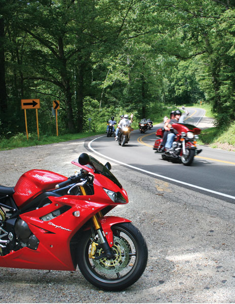
Of course, while I like having a destination, I enjoy a fun ride, too. My goal, then, over the past several years has been to find the best possible combination of county roads and state two-lanes to take me to my old West Virginia home and back. There’s a perfectly serviceable highway, U.S. 33, that I could join just two blocks from my house and follow nearly all the way to my destination. Substantial quantities of federal pork barrel funds have been applied to U.S. 33 in recent years to make it straighter and wider, and to route it around small towns. This is great for folks in cars, whose only goal is transportation, but where’s the motorcycling fun in that?

I do hop on U.S. 33 to escape the urban area, but just a few miles southeast I veer east on Pleasantville Road. Just past the stoplight-free town for which the road is named, I turn south on Ohio 664 and enter the westernmost folds of the Appalachian foothills. On summer Sundays it’s common to meet sport riders on 664 from as far off as Cleveland who have headed south for the day to seek curves. There’s a five-mile stretch of 664 between the little towns of Rushville and Bremen that gets me limbered up for the hills to come. First, it throws at me a few of the blind rises typical of eastern Ohio backroads (there’s a reason the Stayin’ Safe Motorcycle Training course uses this area to teach the concept of managing sight distance) before running me through a corkscrew passage of shady woods and past an orchard.
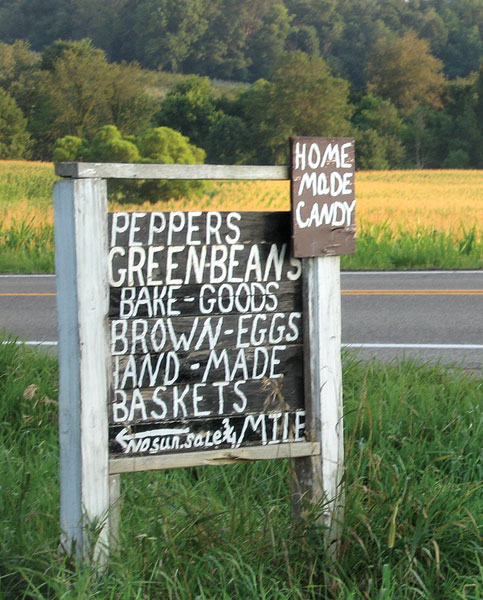
After slowing for the farming town of Bremen, I can turn right to stay on Ohio 664 or I can continue straight, which actually puts me on Ohio 312. Today, I choose 312 with the consolation of promising myself to return via 664 the next day. The farm surrounding this T-shaped intersection is owned by an Amish family, and if my timing is lucky, in the spring I get a view of the farmer driving his team of workhorses across the field, plowing the earth the old-fashioned way.
Ohio 312 offers sweepers through more farm country, but by itself it doesn’t get me where I need to go. That’s where years of experimentation pay off. I’ve pieced together a series of curvy sections that take me through part of the Wayne National Forest. Where Ohio 312 ends, I ride Ohio 93 a few miles to the little crossroads of Gore, where Gore-Greendale Road leads me to Ohio 595 south and then Ohio 278 south into Nelsonville through the back door. All these roads are lightly traveled, nicely coiled and heavily wooded.
For years, when I lived in other parts of the world, any trip home would often involve a stop in Nelsonville at the Rocky Boot Factory Outlet in the old brick factory building on the town’s main drag. When I first visited the outlet store years ago, it still shared space with a taxidermist’s operations and dusty boxes of boots were stacked semi-randomly on bare metal shelves. But when I happened to find my size, I walked out with an unbelievable deal on Gore-Tex boots.
Today, the taxidermist is long gone and the old factory building is a well-lit four-story store that sells not just shoes and boots, but also blankets, shirts, socks, pocketknives and the sort of cute little animal statues my wife likes to put on a shelf. There’s even a café. Incredible bargains are fewer, but dig deep into the remainders and they’re still there.
Leaving Nelsonville, I succumb momentarily to the convenience of U.S. 33. This wide-open four-lane with its maddeningly unnecessary 55-mph speed limit and heavy attention from the Ohio State Highway Patrol serves only to get me to Athens, where old trees tower alongside the brick dormitories of my alma mater, Ohio University.
Local knowledge again spares me from the newest section of U.S. 33 just beyond Athens, a straight two-lane recently plowed through the southeastern Ohio hills to replace a 12-mile stretch of tangled roadway through woods, farms and tiny communities of a dozen or so houses each. The old road is still out there, with its signature blind 90-degree turns, but now it’s called County Road 33A and nobody uses it except the locals. Always a good motorcycling road, now it’s a good and empty motorcycling road.
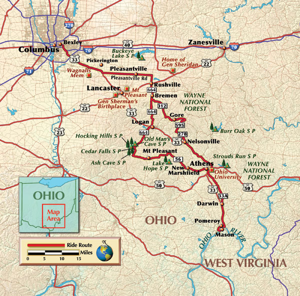
About all that’s left is to cross the bridge connecting Pomeroy, Ohio, with my hometown of Mason, West Virginia, and I’m home again.
For the return trip, I again take advantage of 33A to get to Athens, then pick up Ohio Route 56, which entertains with dozens of sweeping curves as it carries me west into the Hocking Hills State Forest, where I turn north onto Ohio 664. Routes 56 and 664 take me past Ash Cave and Old Man’s Cave, sandstone cliffs and recesses that are a short walk from the road and offer a scenic and cool escape on a hot summer day. Once on 664, especially north of the town of Logan, I enjoy some of the most relentless curves of the entire ride, the ones I skipped the day before only because I knew I’d hit them on the way back.
After enough trips, I’ve learned the danger spots, from the sightseeing traffic in the Hocking Hills on summer weekends to the slew of gravel always kicked across the unexpectedly sharp 90-degree turn in front of the Coonville Holiness Church. This particular route is just one of a dozen or more options to get to my destination, and there’s something to be said for all of them. But after years of experimentation, I can safely say this one is my favorite ride.


 | Ep. 69 Rider Magazine Insider Podcast")

