I’m barreling along a tiny Colorado highway on a sparkling sunny June afternoon with Asleep at the Wheel’s country music in my ears and a shiny new Moto Guzzi in full song. I turn north and there, over the corrugated peaks of the San Juan Mountains, is an apocalyptic plume of black smoke. Not again.
But this was par for the course on this five-day lap around Colorado. My target was Ouray, the southwest Colorado mining town nestled deep between craggy canyon walls. I had intended to escape Denver heading southwest straight into the mountains, but the gods had other plans and tossed a wildfire right along my proposed path. Luckily the traffic and tedium of Interstate 25 was a small price to pay for what was to come.

Reaching Colorado Springs I dove southwest, following State Route 115 alongside the massive Fort Carson military post. I feared the gleaming chrome tank of my new V7 Racer would attract unwanted attention from some watchful fire control system, but I cruised by undetected. My goal was State Route 165, all curvy switchbacks and elevation gains along the Wet Mountains. I stopped to examine the incomparably odd Bishop Castle, a 46-year labor of love and madness, a towering mass of stone, steel and concrete complete with a fire-breathing dragon. Really.
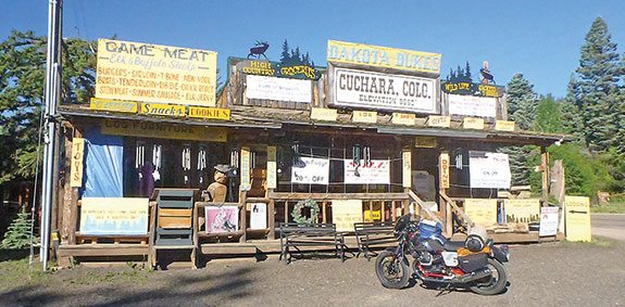
Day 1 ended in the lovely Cuchara Valley, just west of the Spanish Peaks, which were of course on fire. Colorado Route 12, the Highway of Legends, is all hide-and-seek curves, detouring around massive volcanic dikes and widely spaced valley ranches and cabins. The tiny town of Cuchara was my stopping point, with free lodgings courtesy of dear old Dad. You should try the Cuchara Inn, and do not miss pizza and beer at the Dog Bar & Grill.
Day 2 was planned as a straight run on U.S. Route 160 across the bottom of Colorado to Durango, taking in the Great Sand Dunes National Park and Preserve and the always-fun 10,856-foot Wolf Creek Pass, but the latter was closed because of a massive wildfire. Ahem. I detoured south from Alamosa on U.S. Route 285, turning west on State Route 17. Lower in elevation than Wolf Creek, it provided a delightful alternative with smooth asphalt, gentle climbs and curves, and peaceful aspen glades. I got to play hide and seek with the old trains of the Cumbres & Toltec Scenic Railroad, crossing the tracks half a dozen times before I got to Chama, New Mexico.
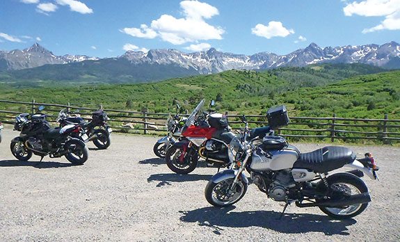
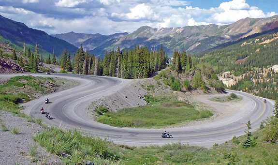
Ending my detour, I returned to U.S. 160 and headed west to Durango. Finally it was time for U.S. Route 550 to Silverton and the start of the Million Dollar Highway. A bucket list ride for any motorcyclist, it was named for the extravagant cost required to widen the old mining pack trails. Complete with terrifying sheer drop-offs, never-ending peg-scraping hairpins and all the near-stationary RVs you would ever like to pass, you will encounter traffic in the summer but will still enjoy it. I hit Ouray around 4 pm, spent but happy, and spied a lit vacancy sign for the 122-year-old Hotel Ouray. It was inexpensive, comfy and directly across from the rooftop dining at the Ouray Brewery.
Day 3 would be a loop, starting with a short run north to Whitewater. Riding west on State Route 141, the arrestingly named Unaweep-Tabeguache Scenic and Historic Byway, I found wide, sparse valleys and leafy river crossings, with no worries other than the occasional cattle guard. Hidden in this corner of nowhere is the Gateway Auto Museum, with 50 or so American classics and even a couple of two-wheelers, unbelievably shiny and very up-close and touchable (but please don’t). After a restorative bratwurst and tater tots on the museum patio, I followed the magnificent Dolores Canyon all the way back to Ouray, with utterly empty sweepers surrounded by massive Wingate Sandstone canyon walls. Budget some time here; several sections are worth repeating, maybe once at full steam to work on your go-fast technique, then again more leisurely to check out the hanging water flume left by the miners.
Day 4 was north again out of Ouray. I turned east on to U.S. Route 50 and wove alongside the stunning Black Canyon of the Gunnison, 35 miles of pleasant curves. Things got even better after I turned north onto State Route 92, tracking back along the north rim with even more hairpins, swoops and scenic overlooks. After a quick lunch in Hotchkiss, I went north on State Route 133, an easy ramble through the wine country around Paonia and then through the White River National Forest. Reaching Glenwood Springs I sought refuge in the Glenwood Hot Springs Pool, a relaxing oasis for mountain travelers since 1888.
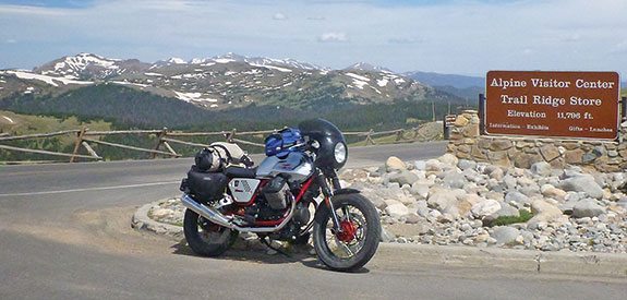
Day 5 was time to go home. West on I-70 provides the best our great nation has to offer in Interstate freeway travel, with 20 miles of elevated curviness. After that it gets boring, so I headed north on tiny Colorado River Road (County Road 301) at Dotsero. This forgotten shortcut of old tarmac and gravel is delightful, flowing past farms and ranches, and following the curves of the just-hatched Colorado River. From there it was nothing but two-lane up to Rocky Mountain National Park. Trail Ridge Road is the highest continuous paved road in America, always tourist-filled but stunning in small details and vast vistas. Descending from the peak of 12,183 feet, I pinballed around the elk-gawking tourists in Estes Park and then headed for home. I couldn’t help but notice—no smoke. Nice.
(This Favorite Ride was published in the June 2015 issue of Rider magazine.)
 |
 |
 |
 |
 |
 |


 | Ep. 69 Rider Magazine Insider Podcast")

