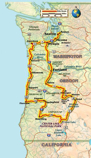
How far can you ride in three days? That was the question I asked myself while planning a loop tour from the city of Seattle into western Oregon. In early July, I had a three-day window and had been looking for the opportunity to ride U.S. Highway 101 along the Oregon coast. After that, depending on remaining time and progress, I’d go east to Crater Lake National Park—one of the few national parks I had never visited before—and then loop back to Seattle.
Summer in the Pacific Northwest can be a very unpredictable season. On a group ride in eastern Washington the previous week, I got caught in a day-long rain and the temperatures dropped into the upper 50s. It was the peak of summer, but even with a rainsuit, layered clothing and riding gear that should have been suitable for temperatures into the 50s, the unexpected combination of rain and cold resulted in one of the most miserably uncomfortable days I have ever spent on a motorcycle. I resolved not to be unprepared again, and for this three-day tour I packed summer riding gear, winter riding gear, rain gear and everything in between—and I used every bit of it.
From Seattle, getting to U.S. 101 on the Oregon coast by the fastest method requires riding south on Interstate 5 for 62 miles to Washington state’s capital city of Olympia, then taking exit 104 for U.S. 101 heading out toward the coast. Remaining on the 101 will lead northwest and take you the long way around the Olympic Peninsula before turning back to the coast for the ride south. At the six-mile mark, exiting the 101 and taking State Route 8 to State Route 12 for 42 miles leads due west to the town of Aberdeen, Washington. Here, Route 12 rejoins U.S. Highway 101 for the start of the route south.
From Seattle, by the time you reach Aberdeen, you have already traveled 100 miles on the Interstate and somewhat mundane rural highways to get there, and there’s still 25 miles to ride south before U.S. 101 begins a western turn along the Willapa River and out to Willapa Bay. Here, both the roads and the scenery become more interesting as the highway follows the river, then begins to wrap around the western edge of the Cascade Mountains out to the Pacific Ocean.
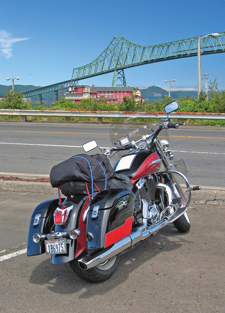
Farther south, Washington gives way to Oregon at the border town of Astoria. The port town lies at the mouth of the Columbia River, which forms the state border, and the beautiful Astoria-Megler Bridge over the river is just the beginning of many miles of great riding. Just south of town, the road turns toward the western edge of the continental U.S. and out to the Pacific Ocean where it begins to resemble California’s fabled Highway 1. Much like that well-known highway, as I rode along the coast, the weather conditions would often go from a cloudless blue sky with bright sunshine and temps in the 70s to foggy and 15 degrees cooler around consecutive curves—the first sunny and warm, the next cloudy and cool.
For a motorcyclist, the beauty of riding U.S. 101 is the opportunity to tackle curves that make the riding fun, while not being so extreme as to slow the pace or require “110 percent” concentration on tight switchbacks. You get a stellar combination of enjoyable countersteering and lean angles, with straightaways that let you look out to the coast and the ocean and absorb some simply outstanding scenery. Long stretches of beautiful highway are conveniently contrasted by seaside towns along the way, offering easy opportunities to fill up the bike and get a bite to eat.
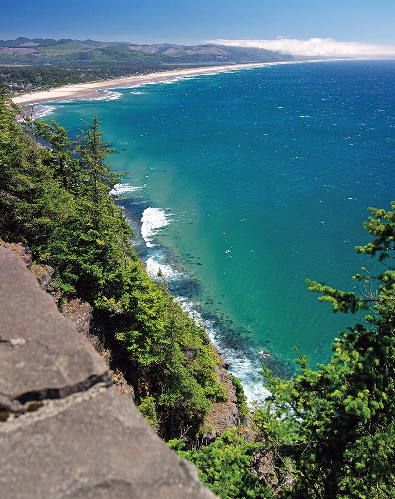
I made it as far south as Florence along this Pacific coastal highway, which is a sometimes elevated, sometimes sea-level ride, and then headed east on State Route 126 toward Eugene. Route 126, also known as the Florence-Eugene Highway, is a very fine two-lane highway that runs through the Siuslaw National Forest, along the Siuslaw River and on to Eugene. The late afternoon sunset bathed the entire area in a warm orange glow, matching the warmer inland temperatures away from the coast. At Springfield, just east of Eugene, I got a room for the night. That morning, I had left the house at 9 a.m., and when I checked into the Best Western in Springfield, it was 9 p.m. It had been a 12-hour riding day.
The next morning, I consulted the map for a route to Crater Lake National Park. I decided on Interstate 5 south to State Route 138 east, a marked “Scenic Byway” that leads to the park. Route 138 is really a great road, but the Oregon Department of Transportation was doing major road work at about 10 locations along the way to Crater Lake, stopping traffic for 5 or 10 minutes each time.
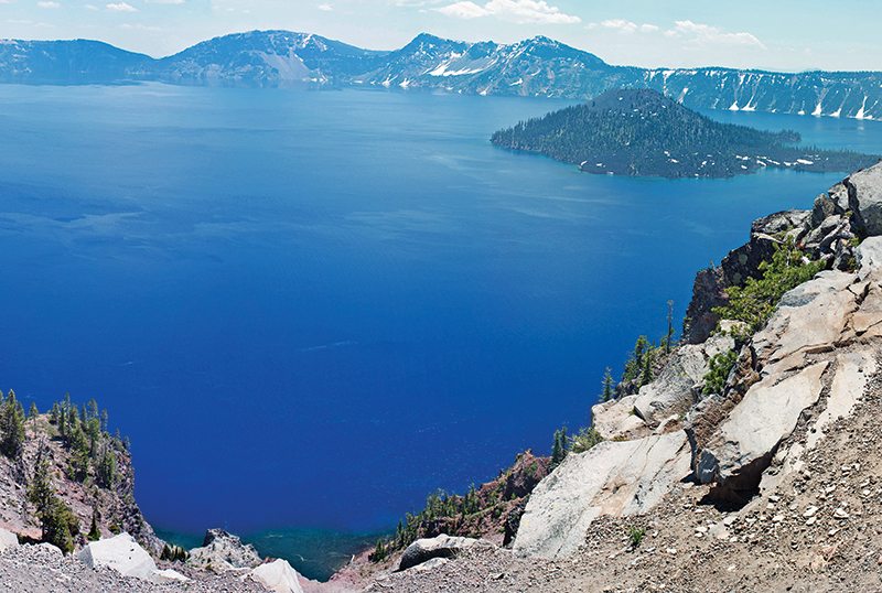
It was certainly worth putting up with the delays, as Crater Lake is an absolutely phenomenal national park, and an incredibly beautiful place! East Rim Drive, part of the loop that runs around the entire lake, was closed at about the 20-mile mark due to snow slides, but I rode as far as I could, snapped some great photos, and enjoyed a conversation with a tour bus driver at the park named Ernie, who offered to take my picture with the bike.
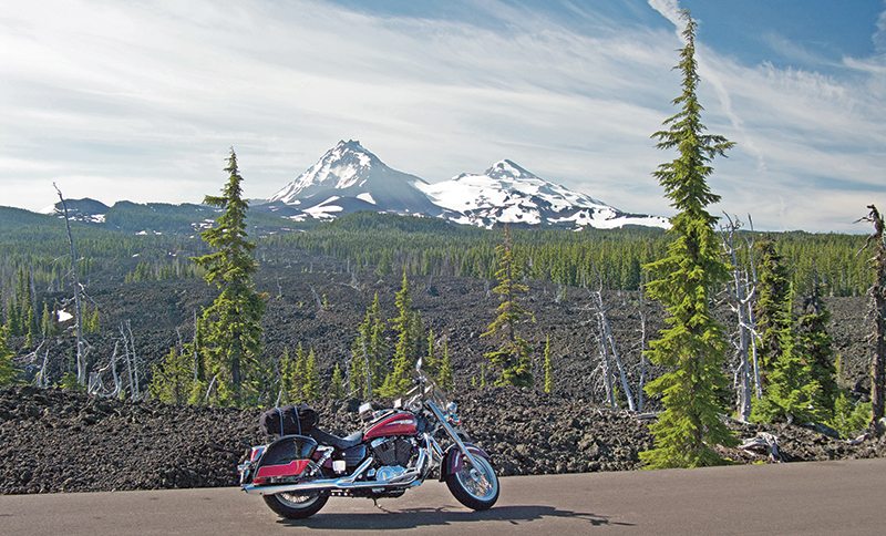
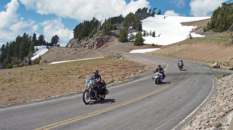
I left the park and rode north to Bend, where I got a room for the night. The next day, I had the opportunity to ride several highly recommended motorcycling roads north of the town, which included U.S. Route 20, State Route 242 (the high point of the day, literally and figuratively), State Route 126 and State Route 22. Route 242 gains about 3,000 feet in elevation as you ride west to the top of the McKenzie Pass and, as you crest the 5,325-foot summit, you see the Three Sisters volcanic peaks to the south and Mount Washington to the north. The mountain highway is beautiful and well paved, but it is very narrow with wildly twisting sections of asphalt that run right along the ridges of the mountain at its elevation, and the road has no guardrail on its outside edge. The steep dropoff would not be forgiving of even a minor error while riding. As Route 242 goes over the pass, it runs through an other-worldly section of deep rust-colored volcanic rock, a complete change from the old-growth pine forest farther down the mountain. It’s an amazing change of terrain and topography within several thousand feet of elevation and a distance of only 20 miles. Route 242 leads to Route 126, and then north to Route 22, and all are great riding roads. At U.S. 20, I headed west for Interstate 5 and home.
What can be said about the beauty of the state of Oregon and the Pacific Northwest that hasn’t been said before? U.S. Highway 101 on Oregon’s coast is a dream ride, and there are so many worthwhile scenic roads and highways in the state’s interior that it would take weeks to cover them all, but I got a good sampling in three days. Crater Lake is certainly one of the most beautiful national parks in the country, and there are so many great locations and so much beautiful scenery on this ride that I spent as much time off the bike as on it, stopping with camera in hand just to shoot away. Coupled with riding a little over 1,100 miles in three days, it truly was a whirlwind tour of Oregon!
(This article Coasting to Crater Lake was published in the July 2014 issue of Rider magazine.)
 |
 |


 | Ep. 69 Rider Magazine Insider Podcast")

