The following is an excerpt from the article Connecting the Dakotas: The Long Way Around North and South, originally printed in the August 2009 issue.
As a motorcyclist who enjoys vacant, isolated roads, I stared longingly at the Dakotas on my National Geographic wall map while planning my next excursion. Unlike August when the Sturgis madness is in full swing, the road ahead and behind me lay vacant, urging me into the sweepers.
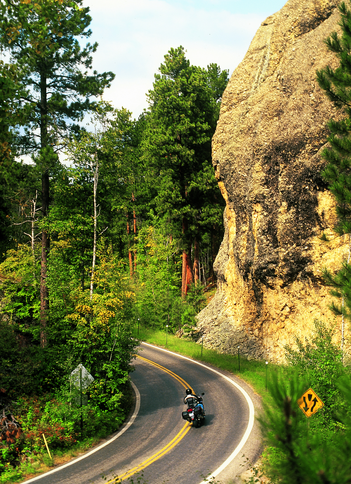
- The Beemer pirouetted the hairpins and whirled around pigtail bridges on Iron Mountain Road in South Dakota. I nodded toward Messrs. Washington, Jefferson, Lincoln and Roosevelt while passing by Mount Rushmore. After poking through tunnels and threading the granite needles of State Route 87, I encountered the Crazy Horse Memorial on U.S. 385. Sculptor Korczak Ziolkowski began blasting and chipping away his vision of Sioux warrior Crazy Horse in 1949 on Whiteface Mountain. Only the face is complete of an image that will include an outstretched arm and horse beneath.
- I left the Badlands along U.S. 18, entering grassland and woodland that delineate the Pine Ridge. The Black Hills were traditional hunting, worship and burial grounds for the Sioux until the discovery of gold, and treaties were then revoked. Today, the Pine Ridge Reservation serves as a reminder to their disenfranchisement. Just off 18 is Wounded Knee, a site where cavalry troops surrounded a band of Lakota Sioux and began disarming them in December 1890. A shot rang out and the slaughter began, with troops killing nearly 200 Sioux. This massacre effectively ended the Indian wars.
- U.S. 18 later carried me across flat, featureless terrain past indistinguishable towns until I jumped the Missouri River and a series of border routes hooked me up with State Route 50 following the Vermillion River. I entered larger cities now, places like Yankton, cow capital of South Dakota, and Vermillion, home to the University of South Dakota and the National Music Museum.
- North on I-29 brought me to Sioux Falls, which is nestled in a giant horseshoe bend of the Big Sioux River, where the namesake falls tumble and cascade through and over a broad quartzite quarry. Many of the buildings in the downtown historic district are constructed of stone harvested at this site. A bicycle trail follows a greenbelt that completely surrounds the river, with canoe access and fishing holes aplenty. Extensive parks make South Dakota’s largest city of nearly 200,000 more habitable and thusly named one of America’s most livable cities.
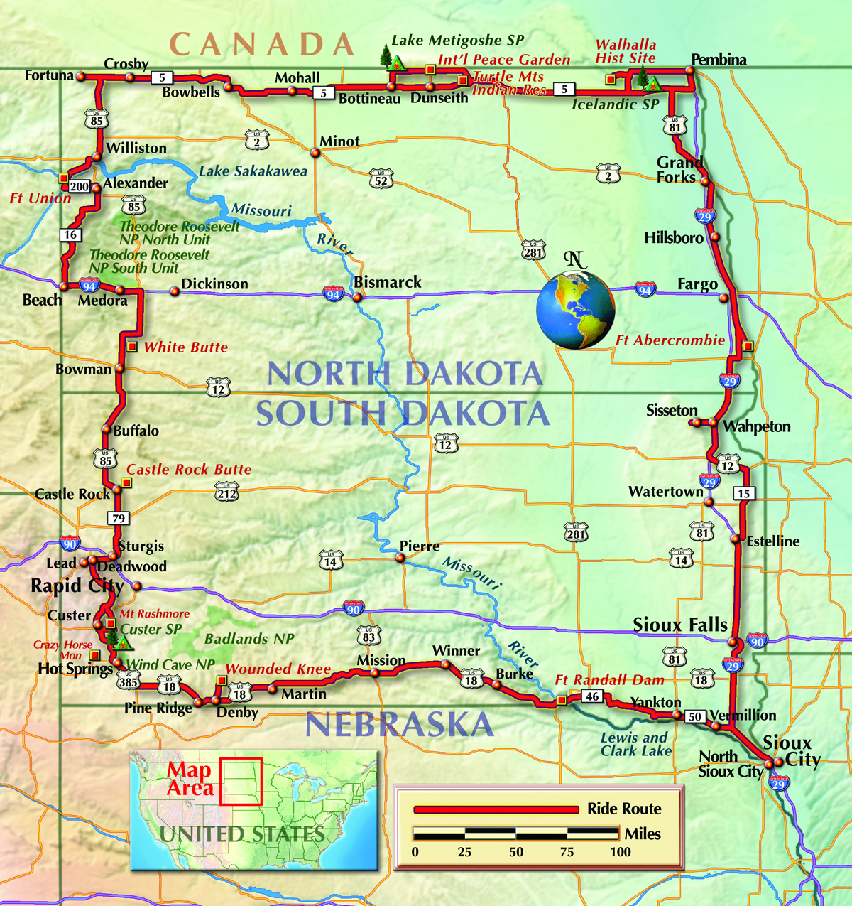
- For the 100 miles from Sioux Falls to Watertown, I’m riding a ridge along I-29 that offers occasional sweeping views into neighboring Minnesota. At the Sisseton exit, I followed State Route 10 west for 10 miles to check out a lookout tower I saw from the distance. This observation post sits atop a continental divide overlooking the watershed where liquid runoff shoves the Red River northward, one of the few North American rivers that do flow upward, so to speak.
Other Great Roads
- The Rapid City South Dakota Convention and Visitor’s Bureau also notes that U.S. Highway 16A, a.k.a. Iron Mountain Road, is a popular route for motorcyclists. The 17-mile road twists and turns from the northeast corner of Custer State Park to the city of Keystone. This road includes most of the tunnels in the state’s highway system. The only four-lane tunnel in the state is located just north of Keystone.
- Iron Mountain Road is just east of the scenic Needles Highway, which is a 14-mile stretch of State Highway 87. Needles Highway includes sharp turns, low tunnels and granite spires. The road lies within in the 73,000-acre Custer State Park, just 30 miles south of Rapid City.
To download a printable PDF of this document, CLICK HERE.
(This Great Roads article was published in the May 2013 issue of Rider magazine.)
To read the full version of the original story, which was published in the August 2009 issue of Rider magazine, CLICK HERE.


 | Ep. 69 Rider Magazine Insider Podcast")

