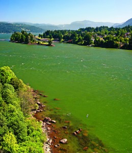
When it comes to unspoiled natural beauty, the Columbia River Gorge ranks as one of the most stunning places on earth. While that may sound like an overly hyped statement in an overly hyped world, in this case it happens to be true. Few places combine as many elements of beautiful geography and topography—mountains, rivers, lakes and temperate zones ranging from lush green forests to arid desert—to create an exquisite feast for the eyes, and a balm for the soul.
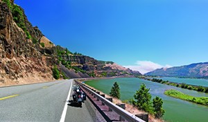
For motorcyclists, it is also a big plus that the stunning geographical features have inspired thoughtful planning and construction of some of the better roads and highways in the Pacific Northwest. Roads follow along rivers or wind through mountain valleys and national forests, allowing you to enjoy some truly stellar motorcycling in this geographically amazing place.
The Columbia River Gorge National Scenic Area is within “day ride” distance for those who live in the Portland, Oregon, area, and is a fairly easy reach for riders as far north as Seattle, northeast to Yakima and Spokane and south to Eugene. Other factors that make it a great ride are the local towns that give the area its Pacific Northwest personality, along with lodging for those wanting to stay and explore the area for several days.
Interstate 84, a beautiful highway in itself, runs along the southern side of the Columbia River, on Oregon’s border with Washington, and overlooks the Columbia. It draws auto and commercial truck traffic away from rural highways and state roads. As a result, local traffic is generally light and towns are less crowded, making motorcycle riding in the area a lower-stress situation. It is an easy matter to find places to have lunch and get fuel, as well as make stops for some “best in the scrapbook” photographs.
Centering your base of operations at Stevenson, Washington, or Cascade Locks, Oregon, puts you in the middle of some of the area’s better riding roads and loops. The easiest commute to the area would be I-5 north or south to I-84 east, but the fun begins by taking the lesser-traveled roads and highways.
![web-Mt. Rainier at Sunset[1] The colors of sunset on Mount Rainier create a visual tour de force.](/wp-content/uploads/2012/12/web-Mt.-Rainier-at-Sunset1-300x186.jpg)
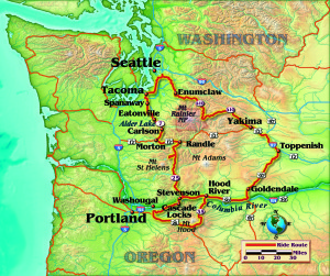
As a resident of the Seattle area, my preferred route is to take I-5 south to Tacoma, which gets you out of the metropolitan area as quickly as possible. Taking Exit 127 onto Highway 512 then State Route 7 south is the general idea, but look for the routes that bypass the town of Spanaway, which include Route 507 and Route 704 (Hart’s Lake Loop Road). While the distance may be slightly longer, it is a better route on the bike, as it avoids most of Spanaway’s time-consuming stop-and-go traffic. Once back on Route 7 south, you’re home free and into excellent riding.
Route 7 parallels the western side of Mount Rainier National Park to the east, and on clear days the road reveals stunning views of the stark and beautiful mountain, often completely covered with snow until well into the summer months. It is the first smile of many on the way to the Columbia River Gorge. Route 7 has mild to moderate twisties that make this an excellent ride, frequented by both cruiser riders enjoying the scenery and sportbike riders enjoying the road. Route 7 also runs by Alder Lake, with a roadside pullout just north of Alder Dam that offers a view of a bald eagle’s nest where the birds return every year to nest. Given the popularity of the road, watch out for traffic at the roadside stops and scenic locations. I have ridden it many times, both on my own Honda Shadow Aero 1100 as well as a 2012 Victory Cross Country Tour, and the road has a good mixture of smooth and scenic straightaways, as well as sections that test your countersteering capabilities.
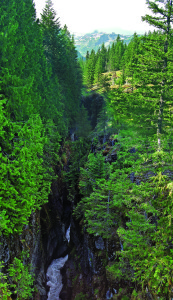
Less than an hour’s ride (36 miles) on Route 7 brings you to U.S. Highway 12 at the small town of Morton. At the meeting of the two roads is a truck stop that has fuel and food. Since many of the roads and areas south to the Columbia Gorge area run through sparsely populated national forest and park lands, I would recommend taking the opportunity to fill your tank.
Taking Highway 12 east for 17 miles leads to the blink-and-you-miss-it town of Randle, and a turn south on Highway 131, also named National Forest Road 25, returns to the route south. NF 25 is one of those storied lesser-known riding roads of Pacific Northwest fame. While the distance from its start at U.S. 12 to the town of Stevenson, Washington, and the Columbia River Gorge is only about 85 miles, it winds its way almost entirely through the Gifford Pinchot National Forest and active geological area, so allow plenty of time for the sometimes extreme serpentine nature and uneven pavement on the road, as well as the scenic stops along the way…and to simply enjoy one great ride. Like many roads in the Pacific Northwest, NF 25 is open only in the warmer months, and opening dates vary every year. You can check the Washington State Department of Transportation website (wsdot.wa.gov) to get current information.
Along the way, look for NF 99, a magnificent 10-mile sidewinder of a road that will get you to some simply fantastic views of Mount St. Helens, as seen from its northeast side. Seeing this still-active volcano does not require you to ride the road’s entire 10-mile length, so it can be a short detour from the route south. The road does not connect to other roads on the western side of the park, so you will have to return to NF 25 to continue on to the gorge area.
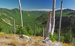
Back on NF 25, another 25 miles brings you to NF 90, also known as Curly Creek Drive. This shorter run of about 9 miles connects NF 25 to NF 30, which leads to the Columbia River Gorge area, and is another gem not to be missed. Look for the McClellan Viewpoint, a state-operated roadside park that is located immediately after an uphill, 180-degree decreasing-radius turn 7 miles from the road’s start, which has more mind-boggling views of Mount St. Helens. Again, the entrance to the viewing area is a popular stop for both motorcyclists and auto traffic. Visibility is limited when both arriving and leaving the park, so be cautious when approaching the area.
NF 90 ends at NF 30, also called Meadow Creek Road/Wind River Road, and the turn south starts the last 27 miles to Stevenson. The three-road route that makes up the 85-mile ride from U.S. 12 is an exceptional ride in itself, and if you travel from the Seattle area by this “scenic route,” you have ridden 191 miles on rural roads and highways. With stops, it is a full-day’s ride. Lucky for you, there’s a good selection of hotels in Stevenson and Cascade Locks, Oregon, just over “The Bridge of the Gods” nearby. The ride to a hotel will give you the first look at the spectacular gorge area. My suggestion would be to get a room with a view (make reservations in summer months!), a good meal at a local restaurant and call it a day.
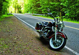
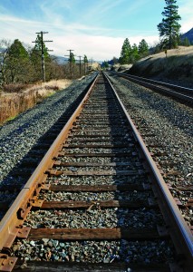
If you’re staying in the Stevenson or Cascade Locks area, taking State Route 14 (also known as the Lewis and Clark Highway) east gives you an opportunity to get in a good long ride along the beautiful Columbia River. Route 14 hugs the northern bank of the Columbia for 165 miles from a starting point at Washougal to its end at I-82, and it is spectacular going for most of this entire stretch. The road itself is excellent—well paved with wide lanes and ample road shoulders that have smooth curves, with small changes in elevation that follow the topography. The road’s less challenging nature gives you the opportunity to enjoy the elevated view of the river and surroundings: the sunlit specular highlights reflecting off the cool green-blue water, as well as the sailboats, windsurfers, personal watercraft riders and water skiers. The view of the mountains across the river into Oregon reveals the ant-sized auto traffic on I-84, as well as the long freight trains that run along the railroad tracks that parallel the river’s southern bank.
From Route 14, there are several options for rides to consider. Twenty-one miles east of Stevenson, a right turn on State Route 35 at the Hood River Bridge begins another excellent 100-mile loop around Mount Hood and through the national forest of the same name. Route 35 connects to State Route 26 and circles the mountain, providing excellent views of Mount Hood from changing angles. Route 26 takes you back toward Troutdale and State Route 30, the Historic Columbia River Highway. It is one of the first highways in the U.S. to have been built on a mountain ridge, and is the oldest scenic highway in the country. It’s a beautiful two-lane, winding road engineered to highlight great views of the gorge and spectacular waterfalls and bridges, and is made for motorcycling. Riding east for the highway’s 22-mile length will take you to I-84 and back to Cascade Locks or Stevenson.
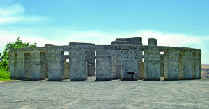
If you want to save the Mount Hood loop ride for another day, continuing east on State Route 14 along the magnificent Columbia River brings you to the Maryhill area and Stonehenge Drive. A right turn there leads to a full-sized concrete replica of the ancient structure built by Samuel Hill as a memorial to World War I veterans. Besides a stop to see and study the amazing replica, you are treated to more great views of the gorge, the Samuel Hill Memorial Bridge (he was a popular guy!) and Mount Hood to the west. Maryhill Loops Road, a private road owned by the local Maryhill Art Museum, can be rented for car, motorcycle, bicycle or skateboarding events.
At the end of your visit, the ride home offers still more options. For those living in the Seattle area, Highway 97 northeast leads through the high desert to Yakima, and taking Highway 12 west to State Route 410 and riding through Mount Rainier National Park on the truly spectacular Chinook Pass (also closed in winter) leads to the town of Enumclaw and back to the Seattle metropolitan area. This is a long 270-mile ride, but it gives you the rare opportunity to ride through three unique topographies in one day: the river and valley areas, the desert-dry Highway 97, and the snow-covered mountain peaks of Mount Rainier National Park.
The beauty of the Columbia River Gorge area makes it an outstanding riding destination, whether you take the scenic routes or the Interstate to get there. Plan to take your time to explore, unwind and fully experience one of the most naturally beautiful and awe-inspiring locations in the Pacific Northwest.
(This article Gorgeous Columbia: Seattle to the Columbia River Gorge and Back was published in the December 2012 issue of Rider magazine.)

