story and photography by Alan Paulsen

Some states just don’t lend themselves to the type of perimeter runs I accomplished on previous tours of Kansas (Rider, November 2007) and the conjoined Dakotas (Rider, August 2009). Yet I still viewed Virginia as a candidate for another of my deranged tour scenarios involving geometric progression. I would follow a primary road across the state’s southern tier, then kind of angle up in an acute fashion following the Allegheny ridgelines paralleling West Virginia’s border. Sort of a tangent, if you will.
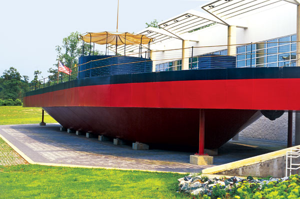
I commenced in Newport News, mainly because a brother-in-law lives there. Christopher works at the prominent shipyard as a reactor plant test engineer, directing the testing and safe operation of nuclear propulsion on aircraft carriers. The latest platform he worked on is the recently commissioned USS George H.W. Bush (CVN-77), a massive contrast to the shipyard’s first vessel delivered in 1891, a rather modest tug on display in town.
Chris took me to the Mariners’ Museum, where the salvaged remains of the Civil War ironclad USS Monitor are preserved. The Monitor’s battle against the South’s ironclad, the CSS Virginia (formerly the USS Merrimack), took place off the shores of Newport News in 1862. Also on display here is a full-scale mockup of the USS Monitor.
A whirlwind tour followed to the Virginia Air and Space Center; NASA’s giant wind tunnel facility near Langley Air Force Base, where the nation’s first astronauts were trained; aircraft displays at Air Power Park; Victory Arch, a French Arc de Triomphe facsimile commemorating troops returning victorious from World War I; Fort Monroe, the largest stone fortification ever built in the United States; and Yorktown, where the British surrendered to Washington. Phew! Jamestown and neighboring colonial Williamsburg will just have to wait for another visit.

I rode over the gently arching span of the James River lift bridge to pick up State Route 10, so-named Colonial Trail beginning at historic St. Luke’s Church, a tiny Gothic brick structure dating circa 1632. Along this route I passed a Colonial-era tavern and homes, cruised through Victorian-themed Smithfield, and caught sight of Bacon’s Castle, a Jacobean architectural gem built in 1665. Outside of Surry I wandered into Smith’s Fort Plantation, erected here 150 years after Captain John Smith established his fort nearby and wooed Pocahontas.
Out of Spring Grove I intended to follow State Route 40 pretty much across the state. In the town of Waverly I encountered the Miles B. Carpenter Museum of Folk Art and the claimed first peanut museum in the USA. Turns out the deceased Miles was an artist noted for his “…elegant American folk carvings that projected a droll, playful sense of humor.” This museum used to be his shop, and peanuts being the primary regional crop, someone decided to incorporate that theme as well.
As it is, State Route 40 passes by the aforementioned peanut crops in addition to corn fields and through pockets of woods. It’s a pleasant cruising two-lane with minimal traffic. But as I crested a rise, a turkey vulture or hawk had just arisen from some road kill at my approach and whacked the left side of the BMW and my arm, pulling off the Beemer’s mirror in the process. I had to troll the roadside verge back and forth until I located the mirror and popped it back on, which it is designed to do. There was no sign of the bird, but some feathers are embedded as a keepsake.

Startling signs through Fort Pickett warn of tank crossings, as if we motorcyclists don’t have enough concerns about the regular hazards. The nearby town of Blackstone represents itself well as a row of neat storefront facades with ornate cornice eyebrows framing awning noses jutting over welcoming walkways. Another inviting town was Charlotte Court House, where Robert E. Lee and Patrick Henry (“Give me Liberty, or give me Death!”) held sway. Indeed, not too far down the road from here is Red Hill, the final plantation home of Patrick Henry, and I wandered the placid grounds, paying respect at the patriot’s gravesite.
After a night of camping at Smith Mountain Lake State Park, I trundled on over to Booker T. Washington National Monument located on farmland where he was raised a slave. When set free after the Civil War he sought an education and eventually founded the now prestigious Tuskegee Institute, a vocational school for African-Americans in Alabama.
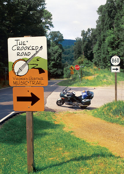
State Route 40 out of Rocky Mount begins Virginia’s Heritage Music Trail, also known as The Crooked Road as it sways through the mountains of the state’s southwest corner. The sounds emanating from this region are mountain music, bluegrass, gospel and traditional country. The road itself west of town indeed became lyrical, curving back and forth on itself like a treble clef. State Route 40 feeds into a slice of State Route 8, where the Heritage Music Trail picks up and in turn empties onto U.S. 58 westbound. There the road bounds over Lover’s Leap and vaults the Blue Ridge Parkway past the oft-photographed Mabry Mill. At Galax, bluegrass bands play continually at the Rex Theater, where an old fiddler’s convention is held each year.
U.S. 58 struck notes of harmony west of Independence as it climbed a do re mi scale. The road gained in tempo as it rose into the Grayson Highlands and Spur 362 brought into view Mount Rogers, Virginia’s tallest peak. More enticing roads wrapped musically around the Highlands skirting Mount Rogers on a gradual descent into Marion. Looking for a place to camp I headed out of town to Hungry Mother State Park, built by the Civilian Conservation Corps in 1936 and listed on the National Register of Historic Places. The park office is a veritable nature museum full of dioramas, taxidermy and other exhibits. I rode the mountain-knob rimmed lake to my campsite, erecting my Eureka Timberline on a raised wooden platform sheltered by a dense tree canopy. Although it rained overnight, the tent stayed dry.
A sign on State Route 16 heading north from Hungry Mother warns truckers that it was their last chance to turn around. That indicated to this motorcyclist unobstructed fun ahead as the switchbacks jogged around additional warnings cautioning 15 mph. And they meant it! Picking up State Route 42 north, I followed alongside the Appalachian Trail for 50 miles to Poplar Hill. Three miles later I diverted to Route 730. On this Virginia trip I learned that the state’s triple-digit route signs indicated secondary roads that were usually winding without a center stripe. This one was a beauty for a dozen miles to Eggleston past farmland vistas with mountain backdrops and ridges ascending from the roadway.
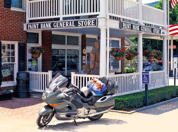
Back on State Route 42 out of Newport I continued to skirt between ridgelines, edging along the Great Eastern Divide at 2,704 feet. At New Castle a swing onto State Route 311 took me over yet another ridgeline on beautifully engineered sweepers. I paused at the motorcycle friendly general store in Paint Blank with its inviting porch. Inside is the Swinging Bridge Restaurant. State Route 311 nips a piece of West Virginia and I soon skewed onto State Route 159 into Covington.
U.S. 220 twists out of Covington past Falling Spring Falls and a vista of the Allegheny Highlands. Between Hot Springs and Warm Springs is The Homestead, an opulent resort originally built in 1766, which has hosted presidents from Jefferson to Franklin Roosevelt, who partook of the “healing waters.” We humble patrons may also indulge at the clothing optional Jefferson Bath House, where waters soothe at a constant 92 degrees.

Monterey is a valley crossroads town that draws motorcyclists for tours into the surrounding Western Highlands extending into West Virginia. As it was, I encountered an annual gathering here of the Christian Motorcyclists Association. In the spirit of brotherhood they invited me to their morning breakfast. When I asked if this was contingent on my attending services I was told, “Heck, no. After breakfast we ride!” The National Landmark Highland Inn offers gracious accommodations and upscale dining. Across the street, High’s Café serves up home cooking and fresh baked desserts.
I headed east on U.S. 250 across the gaps of the Shenandoah Mountains, and when I arrived in Churchville 40 miles later a grinding sound soon became a destructive noise that rocked the Beemer to and fro. I also discovered that oil had coated the right side of the rear tire. Conclusion: A destroyed rear main drive bearing, not uncommon on the K 1200 LT, especially with 84,000 miles on mine.
Prevailing upon the accommodating receptionist in a dentist’s office, I contacted the regional BMW dealer named Morton’s located 120 miles away in Fredericksburg. The bike and I were transported. In the capable hands of mechanic Karl Verden, I was ready to go in less than four hours the next morning.

My, this was quite some tangent I told myself as I headed back to Churchville to resume my journey up State Route 42. Having been there, I reacquainted myself with Natural Chimneys, several limestone towers jutting up 120 feet. A Jousting Hall of Fame is located here, and tournaments are held on the grounds twice a year. Now, knights don’t knock themselves off horses during these tournaments, but riders do pinpoint lances into a small ring at a gallop. In addition, the Shenandoah 500 Motor Event is held the first weekend in October, which draws the dual-sport crowd.
I entered the Shenandoah Valley and motored along U.S. 11 to Endless Caverns, located on the slope of a mountain ridge that offered views back across the valley I had just traversed. Spectacular as they are, the caverns still can’t compare to Luray up the road on U.S. 211. The Luray Singing Tower is located across the road from the cavern entrance. The freestanding tower, called a campanile, contains 47 copper bells that peal when struck by clappers connected to an organlike keyboard. Recitals last 45 minutes, but the schedule varies, so inquire at Luray Caverns.
My final route up Virginia would be U.S. 340, the Stonewall Jackson Highway passing below Skyline Drive to the east. Front Royal is a royal pain to get through, as the junctions zigzag through a congested sprawl. But U.S. 340 stretches into countryside once again on its way to my terminus at Harpers Ferry where Virginia, West Virginia and Maryland converge at the confluence of the Potomac and Shenandoah rivers.

Harpers Ferry is noted for the armory that abolitionist John Brown seized in hopes to arm freed slaves for a rebellion. Brown’s small band of liberators was decimated, and he was hanged for his effort. Many other prominent men of history passed this way, a veritable cavalcade of presidents, explorers, military heroes and black statesmen orating for the cause of freedom. While visiting, I noted that Harpers Ferry is midpoint on the Appalachian Trail between Maine and Georgia.
That sort of describes my dilemma as a touring motorcyclist: I continually find myself at a midpoint between one destination and another. And I often wonder if that’s so bad.


 | Ep. 69 Rider Magazine Insider Podcast")

