story and photography by Sean Coker
[Southern Washington Motorcycle Touring: The Cascade Mountain Range was originally published as a Favorite Ride in the May 2009 issue of Rider magazine]Klickitat Indian folklore has it that the Cascade Mountain Range was punishment for two brothers who could not share. Supreme god Tyhee Sahale (“great chief up above”) had two sons, Klickitat and Wy’east, who fought endlessly. So Sahale banished both—Klickitat he sent north of the Columbia River and Wy’east south. Sahale then built The Bridge of the Gods to allow his family to meet occasionally, and he put an old woman named Loowit in charge of the bridge and gave her youth and beauty as payment.
Both brothers fell in love with Loowit and the ensuing war destroyed villages, forests and collapsed the bridge, killing Loowit. Angered, Sahale transformed Klickitat into Mount Adams, Wy’east into Mount Hood and Loowit into the youngest mountain in the Cascade Range: Mount St. Helens.
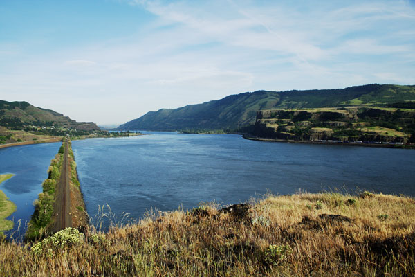
We recently rode through the same land Klickitat and Wy’east fought over, passing picturesque views of their eternal resting places. The Columbia Gorge and wilderness of the Mount St. Helens National Monument brought the old cave explorer’s motto to mind: “Take nothing but pictures, leave nothing but footprints, and kill nothing but time.” Anything is possible in this mysterious land, home to warring Gods, Sasquatch and clues to the 1971 plane hijacking by D.B. Cooper, which are still being removed from the silt floor.
Starting at the Washington end of the modern, cantilevered Bridge of the Gods (those arriving from Oregon must pay a 50-cent toll when crossing the bridge from Interstate 84), we rode east along SR 14. Against a headwind, we came to the town of Stevenson three miles later, where food and gas is available. Continuing east for four miles along the banks of the Columbia River, we carved north onto Wind River Road/Nf 30, following signage to Carson. Stompin’ Groundz (21 Hot Springs Avenue) is located off Wind River Road and serves espresso-style coffee and pastries.
Continuing north, we paralleled the ice-blue Wind River where, in late summer, the river recedes and exposes natural hot springs along its shore. The landscape is colored with Douglas firs and alders that litter the road with needles and catkins, while Indian paintbrushes pixilated the roadside in swatches of red and purple. Slower 30-45-mph chicanes lead deeper into the wilderness, and hazards such as chip sealant, narrow corners and snow banks limiting visibility are present. After 15 miles we turned northeast onto Meadow Creek Road.
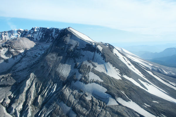
The air got cooler as we neared the 3,050-foot Old Man Pass and, after 13 miles, spun northwest onto Curly Creek Road. Reaching McClellan Overlook, we found a postcard view of Mount St. Helens’ southern face. Continuing west on Curly Creek Road and later Nf 90, thick fog and birch trees crowded Nf 90, giving the road a dreamlike haze as we negotiated 25-45-mph turns with inconsistent traction. A forest of spindly trees created an optical illusion of narrowness.
A sign points to the Ape Caves where, in the summer of 1924, miners were attacked by a group of Bigfoot. Miner Fred Beck claims to have killed one of the large apes and, later that night, the apes retaliated by thrashing the miners’ campsite. Today, Skamania County has an ordinance against shooting Bigfoot. Visitors can follow signage to the Ape Caves, where a 2.5-mile trail snakes below the ground to form the longest continuous lava tube in the United States.
Crossing into Clark County, the road becomes SR 503 Spur. The Swift Reservoir’s sea-foam-green water rests below corners without guardrails. Rocks scatter across the discolored pavement, creating a visually distracting stretch of road. On this sunny day, the transition between sun and shade was abrupt and distracting as we rode 15 miles toward Cougar, where gas is available.
Herons plucked fish from Yale Lake as we passed a hydroelectric dam, although most residents have no access to electricity. Passing the charred foundation of Jack’s Store, we carved south onto SR 503 toward Amboy, where a parachute was recently uncovered that is thought to have been used by Cooper after his successful hijacking. SR 503 runs east and then south before we turned west onto SR 500. Riding south onto Interstate 205 and east onto SR 14, we entered Camas.
Named for the edible flowers that grew here long before subdivisions were the norm, today Camas smells more like a paper mill than an aromatic flower. Entering the Columbia Gorge Scenic Area, 35-45-mph turns ensure riders reach their corner quota, although the State Police patrol the area to fill their quotas, too. Riders can continue east for 27 miles back to the Bridge of the Gods, but for those still seeking corners, head north onto Washougal River Road in Washougal.
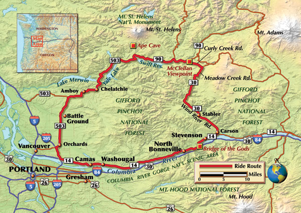
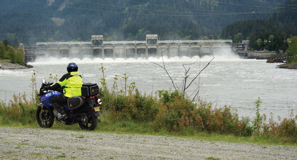
Washougal River Road tacks between outcroppings of rock, guardrails and hillsides like a sailboat in low wind. Blue lupines color the roadside, as the road becomes Canyon Creek Road and we continued east until reaching Salmon Falls Road where we headed south. Slow 10-25-mph turns wind near a small airport, and after five miles of banked bliss we were back at SR 14 and continued east. Passing the Bonneville Dam and snippets of Mount Hood, we parked at the base of the Bridge of the Gods.
Traveling 150 miles through southern Washington, we rejoiced knowing that lean angles and uninhabited wilderness were explored, we left only a carbon footprint and killed four hours in a land so beautiful that even the gods couldn’t share it.


 | Ep. 69 Rider Magazine Insider Podcast")

