
I like Astoria, I really do. Softie and I are riding up Coxcomb Hill, the muted exhaust note drifting off into the clean air. I find it a charming town, full of old houses and beautiful views with hundreds of miles of good riding roads north and south and east. Yes, there is a little bit of road heading out west to Fort Stevens State Park and Tillamook Head, but beyond that is ocean. If you put your bike in a boat and kept going along the 46th parallel, across the Pacific Ocean, you would eventually end up at the southern tip of Russia’s Sakhalin Island. However, I understand the riding over there is pretty poor.
What we have mostly east of us is about 250 or so miles of brilliant riding, spectacular scenery, magnificent views, and a few other superlatives. Nigh on perfect roads for a Harley. We’ve got history and museums, we’ve got brilliant road-building and bridge technology and green (minimal pollutants) hydro-electric dams, and we’ve got a couple of big volcanoes (dormant, we hope) that often pop up in the camera’s viewfinder.

We’ll begin at the end, at the Columbia River’s wide mouth, and work our way upriver. Fortunately we don’t have to deal with the current, as we will be staying on the roads that border the river on both the Oregon and Washington sides—the river is the state line. The roads are a lot safer than the river; out there at the entrance to the river is a big sandbar, and over 2,000 ships have foundered on it in the last 200 years. Nowadays a pilot from Astoria guides the ships in and out, and sinkings have become very rare indeed.
I could see moving to Astoria, as today is a sunny summer day, except locals tell me that the town averages 5 to 6 feet of rain every year, which is a bit more than I care to cope with. We’re at the top of Coxcomb Hill, about 600 feet above the river, on which sits the Astoria Column; the healthy-minded can climb to the top and get another 100 feet of altitude. But even from the base of the tower I get a great view of the 4-mile Astoria/Megler Bridge, which crosses the mouth of the Columbia. That bridge, opened in 1966, was the last link in the completion of US 101, running 1,500 miles from Los Angeles to Olympia, Washington; the whole stretch is a pretty good ride.
I have just come from the Lewis and Clark National Historic Park and Fort Clatsop. A brief bit of local history: this area was home to a small tribe of Indians that called the main village, in their Tillamook language, “a place of dried salmon.” Either Meriwether Lewis or William Clark, whose well-known expedition arrived here in 1805, anglicized the word to clatsop, and called the tribe Clatsop Indians. Near Astoria is a reconstruction of the little Fort Clatsop that the 30 members of that glorious small band of explorers built for the winter of 1805-1806; remember, lots of rain. I see the place while the sun is shining. After Lewis and Clark returned to tell Washington what they had found in this continental crossing, the first permanent American settlement was a fur-trading business set up in 1810 by one John Jacob Astor, a New York businessman—hence, need I say, the name.
Now I’m looking at this big, long, long bridge, and figure that it is definitely worth crossing over; not many 4-mile bridges around. My map shows that 40 miles upriver there is a ferry that crosses over the river back to the Oregon side. I love being nautical, so off we go. On the Washington-state side the road runs through heavy woods before breaking out near the little fishing and tugboat town of Cathlamet. A spur road runs over a short bridge to Puget Island and down to the ferry landing, where for two bucks I get a pleasant crossing back to Oregon. There I ride off the ramp at Westport and find myself on US 30, which runs from Astoria along the south side of the Columbia River for 300 miles, and eventually along Atlantic City on the New Jersey coast if you want to follow it all the way.

At Longview we find the second bridge over the Columbia, a very tall one that allows ships of all sizes to go underneath. We have glimpses of snow-capped mountaintops in the distance, and when we get to the town of St. Helens I make the deduction that that mountain about 40 miles to the northeast is 8,366-foot Mt. St. Helens, which used to be 9,677-foot Mt. St. Helens, until it blew its top in 1980. Southeast I can see 11,239-foot Mount Hood. From here we have to get through the Big City of Portland, and US 30 eventually merges with Interstate 84; but that only lasts a short time as we get off at the Corbett exit, number 22.
We’re headed into the gorge, about a 60-mile stretch where the river cuts right through the Cascade Range of mountains, leaving nothing but steep walls. The pioneers on the Oregon Trail hacked a narrow path alongside the river in the 1850s to allow their Conestoga wagons to get through. Thirty years later the railroad engineers blasted a path wide enough to lay tracks down alongside the river. To do this they compromised the wagon trail, and then to get your wagon through the gorge you had to pay to put it on the railroad. Or you could go around the south side of Mount Hood, a major detour. No fun. Huge amounts of explosives were used in the 1950s to create room for a freeway (later I-84) as well as the railroad.

By 1910 personal transportation was becoming the rage, but there was no real motorcycle or automobile road along the river. Around 1913 a local entrepreneur named Sam Hill decided that he would build the Columbia River Highway, which would become old US 30, and that this would be a scenic destination for all those people riding Harleys and Indians, or driving Ford Model Ts or Chevy Baby Grands. He’d make money off the tourists; this was really America’s first scenic highway. It took almost 10 years to build the entire road, which originally covered about 70 miles, and about half, now known as the Historic Columbia River Highway, remains open to traffic; it makes for a great trip. Sam, appreciating the power output of the engines back then, decreed that no grade would be steeper than 5 degrees. Considerate fellow.
Right away the road climbs to Crown Point, with a marvelous view 700 feet above the river; this first stretch took only a couple of years to build and was opened in 1915. It is spectacular, but you want to stop to admire the views, as that is a long drop off the edge; the Crown Point Vista House provides the opportunity. Then the road drops down closer to the river, and I use those excellent Harley brakes on quite a few occasions. Down low a series of waterfalls from streams coming out of Mount Hood are in view, some hundreds of feet in height. Lovely! The Multnomah Falls are especially dramatic; even Softie was impressed.

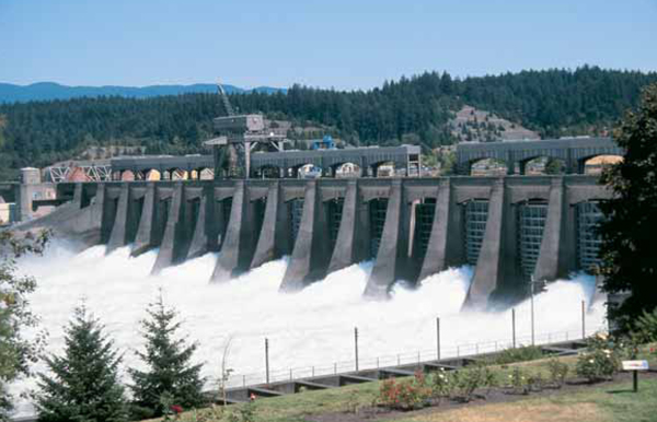
We intersect with I-84 a couple of miles from the Bonneville Dam, which was constructed in the 1930s partially as a WPA project; the US Army Corps of Engineers oversaw the work, but it hired a lot of civilians. Before even the railroad arrived the river was used as a highway to transport goods from the fertile land to the east, and steamboats were using the river back in the 1850s. The big problem was the rapids, as the boats had to be off-loaded and the cargo portaged around the rapids to the next boat. Over the years a series of locks were built, allowing boats to paddle up the river well over 300 miles. A number of tourist boats still run on the river, and anyone interested in parking the Harley for a few hours or a few days can become a passenger.
After a look-see at the Bonneville (named for the same 1815 West Point graduate and explorer, Benjamin B., as were the Bonneville Salt Flats in Utah) we cross over the Bridge of the Gods to get to the Washington side. If you are wondering where the name came from, a long, long time ago a natural bridge spanned the river here, and the locals referred to it as a gift of the gods. It collapsed hundreds of years ago, creating what is now called the Cascade Rapids.
The northern shore is more wooded, with an old two-lane road (Route 14) having a pleasant lot of twists and turns, good for exercising Softie’s gearbox. Slow riding is pleasant, as there is little traffic and the views across the river are great. Forty miles on we recross the river on a mile-long bridge, originally built in 1924, to get to the town of Hood River.

This is a relatively small town, known in the 1850s as the start of the Mount Hood detour. Now, with a population of about 6,000, it has all the amenities that a tourist like myself would need. The community was founded where the Hood River flows into the Columbia and got its post office, a sign of government recognition, back in 1858. I would have liked to stay at the Columbia Gorge Hotel, built in 1921, and I definitely would have had The Wife been along, but no point to spending all that money on a solo stay. Next time. This time I find cheaper accommodations.
Following a beautiful dawn I have breakfast and check the essentials on Softie; all he needs is a tankful of gasoline. We head east on the interstate for 5 brief miles and get off at Mosier in order to connect with the eastern section of the Historic Columbia River Highway and immediately we are headed up to Rowena Crest. With Sam’s 5-degree dictate the road is a gentle series of curves and loops, with the pleasant rumble of Softie’s stock pipes giving a cadence to the climb. We pause at the top and then gently sweep back and forth as we descend to The Dalles.
French voyageurs called this place where the water began its rough-and-tumble approach to the gorge The Narrows (dalles in French). The town was founded in 1851, but the Dalles Dam was not built until 1957, and now the narrows are a calm lake. Just west of town is the Columbia Gorge Discovery Center, covering over 50 acres and telling the visitor everything he or she wants to know about the river; I recommend the visit. There are probably 15 or 20 museums along the river between Astoria and Maryhill, and each one has its own scope.

Softie and I head over the bridge to the Washington side, continuing east on Route 14, where the woods have ended and we are on a wide, open shelf above the river, passing through the village of Wishram, with the Columbia Hills to the north. Then a large neo-classical Georgian building comes into view, very dramatic, standing in its own wooded park. This is the Maryhill Museum of Art, originally intended as a residence for Sam Hill’s wife and later turned into a museum that opened in 1940, featuring the works of leading American and European artists. This is out in the middle of roughly nowhere, and well worth a visit. It is a fine sight, and a finer visit; I should point out that Maryhill is not much more than a post office town, with no tourist amenities other than the museum.
A few miles farther on is the Stonehenge Memorial, a cement replica of Britain’s Stonehenge that Sam Hill built as a tribute to the soldiers who had fought and died in World War I. Sam himself is buried nearby. Softie and I pay our respects.
Then it is time to cross the bridge over to Biggs and find a place to sleep. In the morning we’ll head south on US 97. Places to go. Places to see.


 | Ep. 69 Rider Magazine Insider Podcast")

